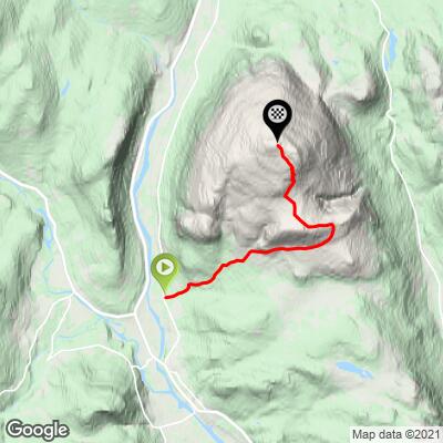
Tron Bike Climb - PJAMM Cycling

12.4
FIETS
6.9 mi
DISTANCE
3,767 ft
GAINED
10.3 %
AVG. GRADE

FULL CLIMB STATS

Page Contributor(s): Ard Oostra (BIG 108), Switzerland

INTRO

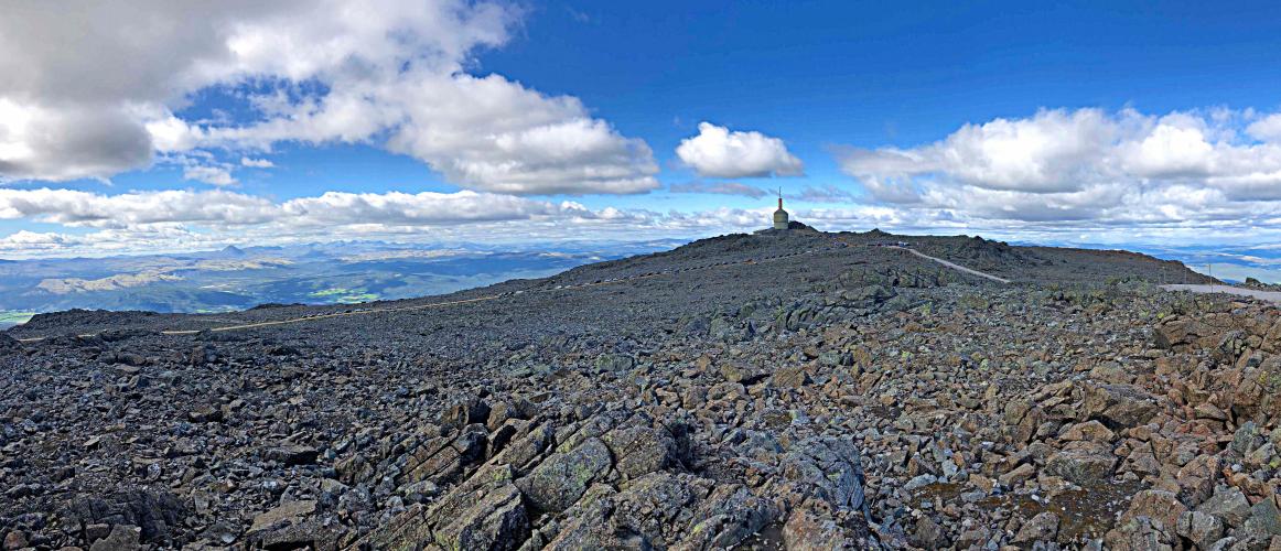
This is a fabulous bike climb in eastern central Norway. Tronfjellet, or just Tron, is a prominent mountain at 1666m altitude close to Alvdal, Hedmark, Norway.  There is a toll road to the summit open in the summer that was built for the purpose of installing a broadcasting antenna in the 1960’s - no doubt because of the climb’s altitude.  Tron is Norway's second highest road. 
This is a brute - 10.4% average grade. 46% of the climb is at grade 10-1% and 11% is at 15-20%.  The steepest 500 meters is 17.4% and steepest kilometer is 16.1%.

See more details and tools regarding this climb's grade via the “Profile Tool” button.
Roadway:  The road is dirt, but it was improved in 2018 to accommodate tourist traffic and can easily be ridden on a road bike in good weather.

Traffic:  Minimal

Toll:  None for cyclists in 2018.

Parking:  There is a parking area at the start of the climb (MapStreet View). 
Provisions:  There are no provisions on the climb but plenty of choices in Alvdal 2.7 kilometers south of the climb start (Map). 
Before heading out on any cycling adventure check out our Things to Bring on a Cycling Trip and use our interactive check list to ensure you don't forget anything.
This ride ends at the radio tower at the top of Tronfjellet Mountain where you will have excellent 360 degree views (Google Map + Reviews). 

ROUTE MAP

MEMBER RATING

Not Yet Rated
-
Road
-
Traffic
-
Scenery

CURRENT WEATHER

PJAMM TRIPS ADVENTURE STARTER BUNDLES

Check out PJAMM Adventure's prepackaged (self-guided) cycling trips. They will help you plan, document and conquer your next adventure.
ALL TRIPS
Browse all of our prepackaged trips and find your next adventure!

NEARBY CLIMBS (0) RADIAL PROXIMITY

FROM
No Climbs Found

MEMBER REVIEWS & COMMENTS

Let us know what you thought of this climb. Signup for our FREE membership to write a review or post a comment.
Already have an account?
ROUTE MAP
PROFILE TOOL
Route Data
S.G. (%)
hide
Segment Data
hide

Climb Profile Not Found
CLIMB SUMMARY

Ride 11.2 kilometers gaining 1,156 meters to 1,644 meters elevation at 10.4% average grade.

Tron (BIG no. 12)

Thank you to our friend Ard Oostra (BIG 108, Switzerland) for this write up and photographs.


Tronfjellet or just Tron[1] is a prominent mountain at 1666m altitude close to Alvdal, Hedmark, Norway.

There is a toll road to the summit open in the summer that was built for the purpose of installing a broadcasting antenna in the 1960’s - no doubt because of the climb’s altitude - Tron is Norway's second highest road. This road is toll free for cyclists.  👍


Climbing Tronfjellet - Tron by bike top, radio tower, dirt road, hikers 

If you build a road, cyclists will come . . .

Apart from the first kilometers of the ascent, this unpaved road had a surface of coarse gravel and had the reputation to be (almost) impossible to climb up on a road bike.

However, in the summer of 2018 to promote tourism the middle and upper section of the road have been widened and the surface being smoothened, thus making this climb completely manageable on a road bike equipped with 23 mm tires. Apart from 200 or so meters the road is still not asphalted.  However, the steep gradient remains, especially in the upper section, making it a tough climb.

Climbing Tronfjellet - Tron by bike - dirt road 

No problem for a road bike.

Norwegian mountain weather being rarely mild and without winds, added with the amazing scenery makes Tron one of Norway’s most memorable climbs.

Climbing Tronfjellet - Tron by bike - cement tower and plains below clouds 

Exceptional and unobstructed views from the top.


The climb starts about 2 kilometers north of Alvdal after leaving road no. 3 towards the northeast (approx. 500m altitude). The first 7 kilometers the road goes through forest and along some houses and passes the automatic tollgate. It has an average steepness of about 10%, followed by 1 km of almost flat section.

Bicycle ride of Tronfjellet - Tron - road sign, trees and bike

Forest at the lower portion of the climb.

At about 1300m the road passes above tree line affording panoramic views over the surrounding hills and valleys.


We are above tree line by km 3.

After leaving the forest, we can see the road snaking above and towards the summit, its light brown surface clearly contrasted from the darker mountains surrounding it. Gradients reach 17% (17.8% 250m segment begins around km 9).  There are several hairpins that provide a serious challenge as the grade of the road increases through them.

Bicyclig Tronfjellet - Tron - hairpins on mountain

Serpentine hairpins leading to the summit.

Those hairpins are STEE   EEEP!

The last couple of hundred meters to the summit are a gentle climb which gives us time to appreciate the gorgeous and unique finish to this exceptional bike climb.

Scenery along the second half of the climb.

The bonus for this climb is that you have TWO summits 400 meters apart, each topped with a communications tower and accessible by bike.  The smaller concrete structure symbolizing Tron is located on the southwest side just behind the tower on the highest of the two summits.


When asking the locals at the top what “Tron” stands for, they were not sure and thought maybe from the movie  Tron.  My research indicates that Tron may derive from the Norwegian word for hog which may make since because often mountains are named after the shape of animals


Ardworks2020

Thank you Ard Oostra, Montreux, CH and Heiko Linnert, Amberg, DE


[1] The official name on most maps is Tronden