2.2
FIETS
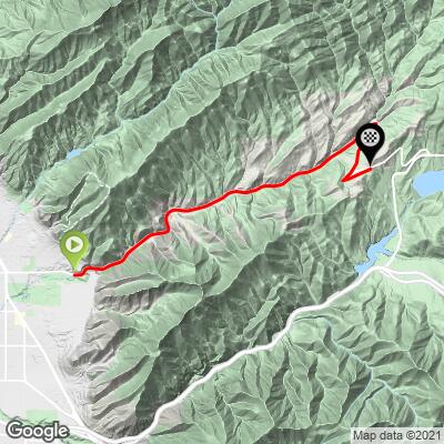
7.6 mi
DISTANCE
1,297 ft
GAINED
3.2 %
AVG. GRADE
FULL CLIMB STATS
Page Contributor(s): Bruce Hamilton, La Quinta, CA, USA; Stacy Topping, CA, USA;
INTRO
This climb is located at the eastern edge of Salt Lake City and climbs into the Wasatch Mountain range of the Rocky Mountains, skirting and finally entering Wasatch National Forest just at the finish of the climb. Continue past this summit for the full Big Mountain Summit West climb.
Average grade is 3.2%. The climb has a consistent gradient - 90% is in the 0-5% range, 9% is at 5-10%, and only 1% being descent. The steepest quarter-mile is a quite manageable 5.6%.
See more details and tools regarding this climb's grade via the “Profile Tool” button.
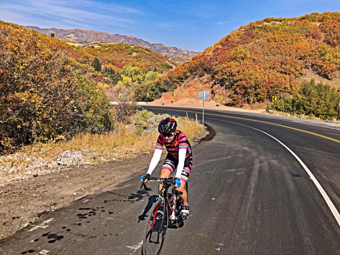
Roadway: Two lanes in fair to good condition with double yellow center stripe and good shoulder most of the climb.
Traffic: Mild, but this one has a little more traffic than some of the other canyons in the area because there are some houses up there so commuter hours might not be ideal. There also tend to be more bikes on this climb because SLC riders can just pop up there easily.
Parking: At the Rotary Glen Bog Park on the right at the start of the climb (Map; Street View).
Provisions: None on the climb but plenty in Salt Lake City just to our west. The closest food and water is at the Hogle Zoo just before the start of the climb.
Before heading out on any cycling adventure check out our Things to Bring on a Cycling Trip and use our interactive check list to ensure you don't forget anything.
This is one of the four paved roads from Salt Lake City into the Wasatch Mountains - others into these great mountains are: City Creek Canyon, and the two big dogs - Big Cottonwood Canyon and Little Cottonwood Canyon. Also see our Park City, UT climb area page for more information on climbs in this area.
You could park at the Hogle Zoo and then tour that great attraction after your climb (Google Map + Reviews).
Use the “Routes in Area” button on the menu bar to see other bike climbs in this area.
ROUTE MAP
MEMBER RATING
CURRENT WEATHER
PJAMM TRIPS ADVENTURE STARTER BUNDLES
Check out PJAMM Adventure's prepackaged (self-guided) cycling trips. They will help you plan, document and conquer your next adventure.
NEARBY CLIMBS (0) RADIAL PROXIMITY
FROM No Climbs Found
MEMBER REVIEWS & COMMENTS
Let us know what you thought of this climb. Signup for our FREE membership to write a review or post a comment.
Already have an account?
LOG IN HERE
akbean
Easy ride and probably the most popular canyon for cyclists in the valley. Can easily get in and out under an hour. Road was repaved in 2020, so it's nice and smooth. Some sections toward the top (before the switchbacks) have tight or no shoulder, but the canyon is so heavily trafficked by cyclicsts the cars should be used to you. Scenery is dull for 90% of the ride, with the only good view coming on the ascent up Little Mountain.
HakenBaconator
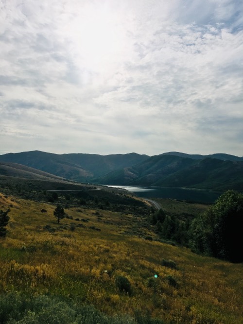


Pretty good climb for a little challenge while taking it easy. The views from Little Mountain Summit are pretty great, and the newly redone road is fantastic. The shoulder on the final switchback is the same width as both lanes of traffic put together. Great place to ride!
manatee44
By far the most popular canyon with cyclists in the SL valley. While there is a fair amount of traffic, drivers are generally aware of cyclists due to the large number of them in the canyon. They recently redid the road so the pavement quality is decent and the bike lanes are well marked and wide with the exception of a small residential section before the switchbacks. This is a great canyon to start with if you are a newer rider.


