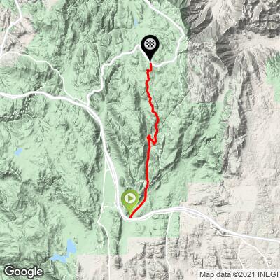
4.1
FIETS
11.5 mi
DISTANCE
2,685 ft
GAINED
4.1 %
AVG. GRADE
FULL CLIMB STATS
Page Contributor(s): Howard Aughinbaugh, Ohio Valley, IN, USA.
INTRO
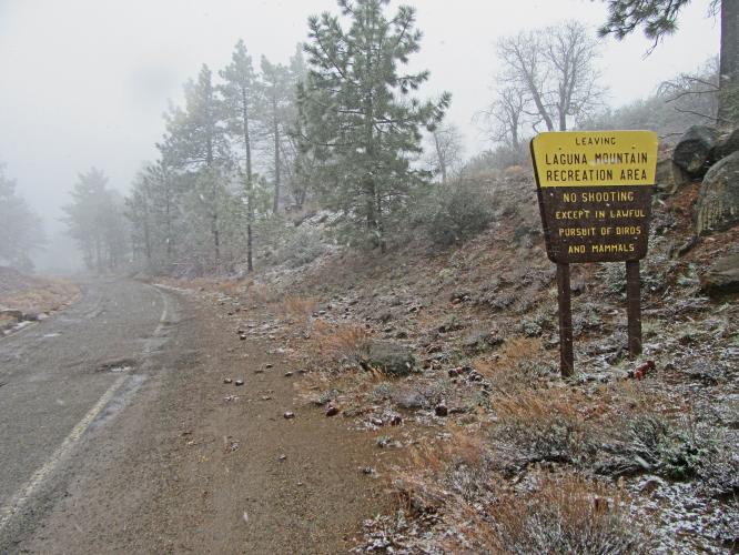
Kitchen Creek Road on Mt. Laguna is a San Diego County outlier (56 miles east of San Diego in the Cleveland National Forest). There are no houses and no provisions along this 11.3 mile ride, so come prepared. It can be tortuously hot with desert-like conditions during the summer.
The average grade of 4.1% increases to 4.9% by eliminating descent from the gradient equation. 37% (4.4 miles) of the climb is at 0-5%, and 52% (5.9 miles) 5-10%. The grade never exceeds 10%. The steepest quarter-mile is 8.1% and steepest continuous mile is 7.5%.
Consult the PJAMM "Full Forecast" feature for the time you expect to arrive at the finish to assess what clothing to bring on your ride.
Roadway: The first 5.25 miles on Kitchen Creek Road are in very good condition. The last six miles after the gate are a little rougher but still very good.
Traffic: Minimal for the first 5.25 miles to the gate. Zero traffic after the gate.
Parking: At the start of the climb - Map; Street View.
Provisions: This is a remote climb and there is no place for food or water along the route. There are food and beverages available at the Laguna Mountain Lodge and Store 15 miles up the mountain from the start of the climb - Map; Street View.
Weather: It gets hot out here so be sure to consult the PJAMM "Full Forecast" feature for assess what clothing and provisions to bring for the climb.
Before heading out on any cycling adventure check out our Things to Bring on a Cycling Trip and use our interactive check list to ensure you don't forget anything.
This is a remote climb 56 miles east of San Diego. The closest option for lodging is the Sycuan Casino Resort which is just west of the national forest.
ROUTE MAP
MEMBER RATING
CURRENT WEATHER
PJAMM TRIPS ADVENTURE STARTER BUNDLES
Check out PJAMM Adventure's prepackaged (self-guided) cycling trips. They will help you plan, document and conquer your next adventure.
NEARBY CLIMBS (0) RADIAL PROXIMITY
FROM No Climbs Found
MEMBER REVIEWS & COMMENTS
Let us know what you thought of this climb. Signup for our FREE membership to write a review or post a comment.
Already have an account?
LOG IN HERE
cyclingamy


It's a good climb! Yes indeed a good number of the last miles are un-maintained pavement with quite a few potholes but unless you're a pro cyclist going 20mph uphill it's not too hard to avoid any issues with the surface. I will say it's quite a bit colder at the top than the start, especially in late December (yes, duh!) and I was unprepared with proper clothing for the decent down the backside of Sunrise Highway. But of course that was my fault and apparently I will truly never learn LOL.
AugieRider50
The first 5+ miles up to the 1st gate was a typical southern CA weathered road with lots of expansion cracks due to heat. Past the 1st gate and up to the 2nd gate, road narrows to single lane, and adds fallen rock and brush growing through the road surface. Zero traffic on this section. Past the 2nd gate up to Sunrise Highway Gate, road surface was abysmal with large potholes, lot's of alligatoring, broken pieces of pavement, rocks, and pine cones all over the road. Not surprising since the county has this section marked as a non-maintained road. I met a fireman / park ranger working on the 3rd gate just off of Sunrise Highway at the top of the climb. He said the county would open the 3rd gate to traffic for the summer soon I think was speaking about the area immediately past the gate. There appeared to be a large parking area just past the gate. The PJAAM summary for this climb only mentions one gate. I was surprised by the other two.
GAJ21
I can confirm that the 3rd gate is usually open. I don't typically head up in the winters but ride it in Fall and Spring a fair amount. Haven't ever encountered the third gate being closed.


