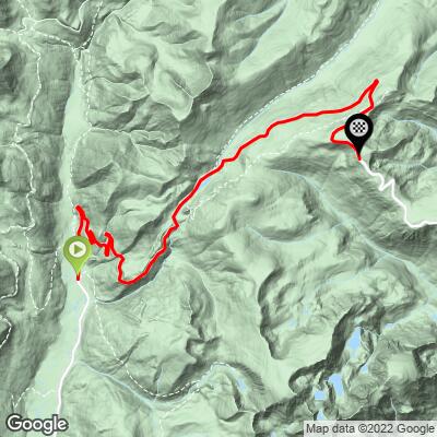
Trail Ridge (Grand Lake) Bike Climb - PJAMM Cycling

7.4
FIETS
12.3 mi
DISTANCE
3,178 ft
GAINED
4.9 %
AVG. GRADE

FULL CLIMB STATS

INTRO

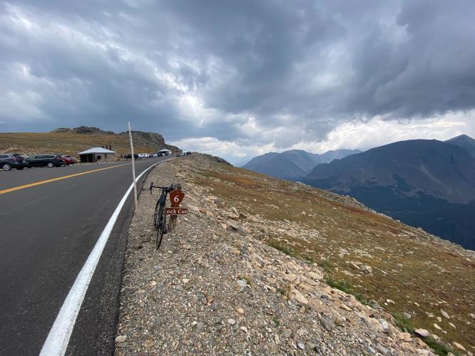
This 12.3 mile bike climb is located in CO, USA. The average gradient is 4.9% and there is a total elevation gain of 3,178 ft, finishing at 12,187 ft.

Use the profile tool, route map, and weather forecast to conquer this cycling climb.

See more details and tools regarding this climb's grade via our interactive Profile Tool.
Roadway & Traffic:
The roadway is in excellent condition throughout the climb. Traffic is mild and not a concern. Road is snowed in and closed to all traffic usually from sometime in early November into late May. Be sure to check the NPS website for road closure information if planning on riding in spring or fall.

Parking: 
There's plenty of parking in either the town of Grand Lake or within the national park along the route at trailheads, scenic overlooks, etc.
There are scenic overlooks with restrooms but otherwise the climb is unsupported.
Before heading out on any cycling adventure check out our Things to Bring on a Cycling Trip and use our interactive check list to ensure you don't forget anything.
Grand Lake is an awesome rocky mountain town to stay in, but our favorite place to stay is in Estes Park due to its proximity to Boulder, Denver, and the other climbs in the Front Range. 

ROUTE MAP

MEMBER RATING

Not Yet Rated
-
Road
-
Traffic
-
Scenery

CURRENT WEATHER

PJAMM TRIPS ADVENTURE STARTER BUNDLES

Check out PJAMM Adventure's prepackaged (self-guided) cycling trips. They will help you plan, document and conquer your next adventure.
ALL TRIPS
Browse all of our prepackaged trips and find your next adventure!
Colorado: Front Range
United States (CO)
20 ROUTES
46 POIs
ROUTE STATS (TOTAL)
563.5
mi
DISTANCE
73,545
ft
ELEV. GAIN
RMNP: Trail Ridge Road
United States (CO)
13 ROUTES
33 POIs
ROUTE STATS (TOTAL)
258.2
mi
DISTANCE
25,530
ft
ELEV. GAIN

NEARBY CLIMBS (0) RADIAL PROXIMITY

FROM
No Climbs Found

MEMBER REVIEWS & COMMENTS

Let us know what you thought of this climb. Signup for our FREE membership to write a review or post a comment.
Already have an account?
ROUTE MAP
PROFILE TOOL
Route Data
S.G. (%)
hide
Segment Data
hide

Climb Profile Not Found
CLIMB SUMMARY

Cycling Trail Ridge Road from Grand Lake (west)

Ride 21.7 miles gaining 3,720’ at 3% average grade.

Although this climb is a robust 21 miles, it is less than one-half the length of Trail Ridge East which at 44 miles is the second longest bike climb in the US and sixth longest in the world.   

Because there are 2 ½ miles of flat/rollers past the finish of Trail Ridge West and the finish of Trail Ridge East, the finish for each are in different locations.

Before heading out to ride Trail Ridge West, be sure to rely on our list of Things to Bring on a Cycling Trip, and use our interactive checklist to ensure you don't forget anything.

When to Climb Trail Ridge by Bike:  This bike climb tops out above 12,000’ so it is best to do it between June and September.  Trail Ridge Road does close during the winter:

“It is open to vehicle traffic roughly from Memorial Day weekend in May through Columbus Day in October. Temporary closings may occur in early June or late fall because of snow. Occasionally it opens earlier in May. Average close date is October 23 (latest close date Dec. 2, 1933) when the Park Service gives up fighting the snow and turns the road back to Mother Nature for the winter. During winter  it is closed between Many Parks Curve and the Colorado River Trailhead.  Call  (970) 586-1222 anytime for the latest Park recording of the status of the road”  (Rocky Mountain National Park).  

Though we’d say that the best months to ride Trail Ridge are June to September, there are never any “guarantees” . . .

Cycling Trail Ridge Road, Estes Park, Colorado - PJAMM Cycling logo in corner, cyclist standing and riding on wet road with extremely tall snow walls on either side

Left photo:  Marloes Dekkers near Rainbow Curve Overlook ~10,875’ -- May 29, 2019

Right photo: Tiemen van Boxtel near Forest Canyon Overlook, ~11,716’ -- May 29, 2019

Both photos are from the eastern approach to the summit.


Bruce Hamilton hiking to high point of Trail Ridge

Bruce on his way up Mushroom Rocks to the summit . . .

2 ½ miles past the finish of Trail Ridge West.

Cyclist holding bike over head at high point of Trail Ridge bike ridge Rocky Mountain National Park Colorado

Mission accomplished at 12,300’.

The road passes the Continental Divide at Milner Pass (mile 15.8 elevation 10,758’).


Continental Divide sign on Trail Ridge   

  Cycling Trail Ridge Road, Estes Park, Colorado - Continental Divide sign 

Continental Divide Top 100 US Bike Climbs:

Cycling Trail Ridge Road, Estes Park, Colorado - Continental Divide signs at Independence Pass, Cottonwood Pass, and Wolf Creek Pass

Wolf Creek Pass (top photo) -- southwest Colorado (Pagosa Springs);

Independence Pass -- central Colorado (Aspen);
Cottonwood Pass -- central Colorado (Buena Vista).