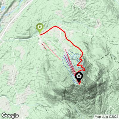
Burke Mountain Bike Climb - PJAMM Cycling

7.7
FIETS
3.3 mi
DISTANCE
2,093 ft
GAINED
12.2 %
AVG. GRADE

FULL CLIMB STATS

Page Contributor(s): Stacy Topping and Bruce Hamilton, Midway, UT

INTRO

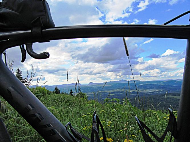
The Burke Mountain bike climb is an extremely steep and challenging climb to the top of Burke Mountain Ski Resort in Darling State Park.   How do you get to #92 on the US climb list with only 3.3 miles of pavement?  By having the steepest 2.5 mile section in the US to climb by bike.  We also have several fantastic views of Vermont's famous Willoughby Gap to our north. 
12.3% average grade for 3.3 miles with 0 descent!  49% (1.6 miles) is at grades 10-15%, 20% (0.7 miles) is at 15-20%, and 5% (0.2 miles) is at ≥ 20%.

Use the “Routes in Area” button in the menu to see other bike climbs are in the area. 
Roadway:  Excellent condition from start to finish.  The road splits to the toll road at mile 1.2 and the final two miles are on a private toll road that is one lane with no center stripe and in very good condition. 

Traffic:  Minimal.

Fee:  As of 2020, no fee to enter the toll road for pedestrians or bicycles.

Parking:  I parked at the lower Burke Mountain Ski Resort parking lot to the right just before the start of the climb - Map; Street View (take a right off Mountain Road onto Sherburne Lodge Road and go 30 yards - huge parking area to the right).
Provisions:  None on the route.

Gear:  This climb is steeper than most you will ever encounter in the US, so bring a bike with proper gearing.  I used a compact chainring and 30t at age 60 in good shape - as a benchmark for you.  
Before heading out on any cycling adventure check out our Things to Bring on a Cycling Trip and use our interactive check list to ensure you don't forget anything.
We stayed in Lyndon which is only six miles from the start of the climb where there are several hotel options - we got in late so I was pushing the clock and thus drove to the start of the climb.  We had dinner at Miss Lyndonville Diner and breakfast at Everybuddy's Causal Dining - both were great and have good reviews.  If you are thinking about staying in the area for a longer period of time you could rent a house or cabin.  

ROUTE MAP

MEMBER RATING

Difficulty: Extreme
4
Road
5
Traffic
4
Scenery

CURRENT WEATHER

PJAMM TRIPS ADVENTURE STARTER BUNDLES

Check out PJAMM Adventure's prepackaged (self-guided) cycling trips. They will help you plan, document and conquer your next adventure.
ALL TRIPS
Browse all of our prepackaged trips and find your next adventure!
Northeast Fall Colors
United States (MA,ME,NH,NY,VT)
24 ROUTES
37 POIs
ROUTE STATS (TOTAL)
98
mi
DISTANCE
35,116
ft
ELEV. GAIN

NEARBY CLIMBS (0) RADIAL PROXIMITY

FROM
No Climbs Found

MEMBER REVIEWS & COMMENTS

Let us know what you thought of this climb. Signup for our FREE membership to write a review or post a comment.
Already have an account?

Jul 25, 2023
difficulty: Extreme
scenery: 4
traffic: 5
road: 5
Jul 25, 2023
scenery: 4
traffic: 5
road: 5
Steepest ride I’ve ever done!! Found myself doing zig zags at times to combat the steepness…the 20% section is killer! After that, it seems at like every turn there’s another tough pitch up! Beautiful views along the way up and at the top! Toll road is in great condition!! Descending can be a little scary and tiring on your arms, I stopped a few times to take in the views and give myself a break…it’s twisty turny and the 20% section is a steep downhill! There is some shade but I had no choice but to do this climb in July at 1pm so the sun was hot! Barely any cars on this one…great challenge!
Aug 17, 2021
difficulty: Extreme
scenery: 4
traffic: 5
road: 3
Aug 17, 2021
scenery: 4
traffic: 5
road: 3
The average grade of 12.7% for 3.3 miles makes this the steepest top 100 climb in the USA. BUT, those stats do not represent the true torture of this climb!! After turning onto the toll road for the last 2.5 miles it averages OVER 14% [I had 14.27%] to the top . That includes a “wall” about .12 miles long at 22% followed by 16%”recovery” slopes. Burke is hands down the toughest pure climb that I’ve ever done. Having climbed Mt Washington and Ascutney(the previous day)several times, along with Equinox, Lincoln Gap East, Mt Evans Colorado, Galibier and Mt Ventoux France, and several other top 100 climbs, that should give u some context/credibility to my statement. Bring your A+ game for this climb. My gearing, 34x34.
ROUTE MAP
PROFILE TOOL
Route Data
S.G. (%)
hide
Segment Data
hide

Climb Profile Not Found
CLIMB SUMMARY

Cycling Burke Mountain - Welcome to Vermont sign

Cycling Burke Mountain, an extremely challenging bike climb in Vermont.

Ride only 3.3 miles but gain 2,096’ to elevation 3,214 at 12.2% average grade.

photo collage shows Burke Mountain Ski Resort, wildflowers, distant mountain views

WOW!  Rarely do we see elevation grids of this continuous color (violet and purple denote 10-18% grades).  There are seven Top 100 U.S. Climbs that average 10%+.  At 12.7%, Burke Mountain outdistances its nearest competitor, #3 Mt. Washington by 0.8%.  In other words, this is The Steepest Top 100 U.S. Climb!  

Garmin device reads 22% 

Garmin does not lie . . . 😳

Here is an (as always) exceptional summary of the climb from the preeminent climb source for the northeast, Doug Jansen, from  Northeastcycling.com: 

Burke Mountain is one of the premier climbs in northern Vermont. This climb is tough, I suspect many find it more difficult than Mt Ascutney. The average grade is about the same, but there are sustained sections that are much steeper than any comparable sustained section on Mt Ascutney. For this reason, it is hard to find a rhythm on this climb. Around the 1.7 mile mark, there is a section that approaches 20% grade for at least a few tenths of a mile. I find it  difficult to keep front wheel on the ground. This grade is comparable only to the east side of Lincoln Gap in the Green Mountains. The race starts on Mountain Road at the ski area entrance. The grade is gentle here, and you'll think you're racing in a road race pack. Once the fork to the Toll Road is taken, the grade immediately kicks up to 14% and stays there until the 20% grade section. The rest of the climb hovers in the 12-15% range. Ski runs are crossed several times on the way up, offering fantastic views and giving you a psychological boost in showing how dramatically you have gained vertical despite crawling at just a few miles per hour. At the summit, a two minute hike from parking area, there is a fire tower that can be climbed for a 360 degree panoramic view. On a clear day, you can see mountains in several states. One of the best things about this climb is the road condition. It has been recently repaved, so the surface is buttery smooth. However, great care must be taken on the descent. Due to extreme steepness and frequent sharp switchbacks, heavy continuous braking is required. Even my MTB disk brakes faded on me one time coming down. This has never happened before riding off-road. Most riders would do well to reduce tire pressure about 10-15% before beginning the descent and stop half way down to let rims cool.   (Northeastcycling's Burke Mountain Page).

PJAMM Cyclists ride the Burke Mountain, Vermont Climb; stand with bikes in front of sign for Burke Mountain Hotel, ski lift behind

Bruce and Stacy chasing PJAMM Top 100 Climbs.

Summary from our August 2015 northeastern climb trip - Mt. Burke:

  • The first mile is shallow at 12%, while the last 2.3 miles (beginning at the toll gate) chomp their teeth in and shake you for the entire remainder of the climb at a lung-popping, quad-burning 14%!
  • We enter Burke Mountain Ski area at mile two and pass over ski runs several times to the top, and under ski lifts a couple times.  Appropriately, the climb ends at the top of the ski mountain at a lift known as Fox’s Folly and a run named “The Shoot” – in ski lingo, that means steep and deep!  

Bike climb up Burke Mountain - under Mid Burke Express - Willoughby Gap

Mid Burke Express lift - Willoughby Gap in background.

  • This is a bit of a “remote” Top 100, but well worth the effort if you are in or near the area (it is only about an hour and a half from Mount Washington and is a good “warm up” for the Mt. Washington Auto Road Bicycle Hill Climb race.
  • Most of the climb is in Vermont Darling State Park.  The Toll road begins at the one mile point (2.3 miles after the gate to the top) and as of August 2015, there was no charge for cyclists (who are free to use the road during the same hours as automobiles).

Climbing Burke Mountain by bike - toll gate and visitor center

  • There are exceptional views of Willoughby Gap, 11 miles on a string to the northwest from Miles 2-3.

Cycling Burke Mountain - view of Willoughby Gap

Willoughby Gap to the north as seen from Burke Mountain.

The gap continues into Lake Willoughby, which is 320’ deep and is surrounded

on one side by Mt. Hor and Mt. Pisgah on the other.

We highly recommend the Miss Lyndonville Diner (686 Broad Street, Lyndonville, Vermont) for breakfast and ambiance.  If you are from out of area (as we were) and are interested in unfiltered Vermont culture, get a seat in the front at 6 a.m. and stay for an hour or two – the locals sit in the front and chat about local events, their lives, and family – it is a great experience (similar to Crescent City, CA where we hail from – if you want to learn about the place, get to the diner early and spend time respectfully listening to the old-timers and fishermen recount their days, tales and lives).  

Other Top 100 climbs within a 100 mile radius in the northeastern part of the United States (#3 Mt Washington, NH, #21 Mt. Equinox, VT., #43 Whiteface Mt, NY, and #57 Mt Auscutney, VT).

.