7.5
FIETS
4.5 mi
DISTANCE
2,190 ft
GAINED
9.1 %
AVG. GRADE
FULL CLIMB STATS
Page Contributor(s): Christopher Jacobs - Boulder, CO
INTRO
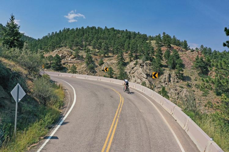
"Magnolia Road near Boulder is one of the steepest climbs in Colorado. Be ready early on as the road is severe immediately and through tight turns. The first mile is the steepest of the route and through several continuous switchbacks that will test the legs. Good views of Boulder Canyon appear in spots if you can lift your head. A short descent appears but soon the grade increases. There are two more big switchbacks to negotiate with grade in their inner corners at 25%. The several small descents you encounter let you catch your breath but also knock down the average grade of this monster. Near the top the slope eases for good and the climb ends just before the road turns to dirt in a pleasant setting..." (This quote is presented with the approval of John Summerson, from The Complete Guide to Climbing (by Bike) in Colorado, pg. 84.)
The average grade for the climb is 9.1% (9.7% without descent). 33% (1.5 miles) of the climb is at grade 5-10%, 37% (1.7 miles) is at 10-15%, and 10% (0.4 miles) is in the 15-20% gradient range. The steepest quarter-mile is 15.8% and steepest continuous half-mile 14.2%.
Roadway: Good condition.
Traffic: Minimal.
Parking: At climb start - Map; Street View.
Gear: I used a compact chain ring and 28t cassette my first time up this beast (at age 57) and compact 42t my second time up at age 63 (in my defense, I only used the 38t cog on the cassette 😊).
Before heading out on any cycling adventure check out our Things to Bring on a Cycling Trip and use our interactive check list to ensure you don't forget anything.
As noted in the introduction, this climb is in the center of the bike universe - the unbelievably bike friendly Boulder, Colorado (see PJAMM's Boulder, CO climb area page). Just across Boulder Canyon Drive is the Sugarloaf Road climb and you can ride to the Magnolia Road climb using the Boulder Canyon, although there is a lot of moderately traveling motor vehicle traffic on that ride.
To plan your ride in the Boulder area, see the Routes in Area tool to see what other climbs are in the area, or check out some of the Ride Suggestions in the Full summary for some full routes.
To plan your ride in the Boulder area, see the Routes in Area tool to see what other climbs are in the area, or check out some of the Ride Suggestions in the Full summary for some full routes.
There are many great places to stay in Boulder including several condo and house rentals in the area.
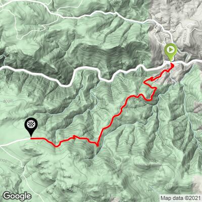
ROUTE MAP
MEMBER RATING
CURRENT WEATHER
PJAMM TRIPS ADVENTURE STARTER BUNDLES
Check out PJAMM Adventure's prepackaged (self-guided) cycling trips. They will help you plan, document and conquer your next adventure.
NEARBY CLIMBS (0) RADIAL PROXIMITY
FROM No Climbs Found
MEMBER REVIEWS & COMMENTS
Let us know what you thought of this climb. Signup for our FREE membership to write a review or post a comment.
Already have an account?
LOG IN HERE


