Mt. Baldy from Hwy 39 (GMR) Bike Climb - PJAMM Cycling

6.5
FIETS
22.5 mi
DISTANCE
5,597 ft
GAINED
3.9 %
AVG. GRADE

FULL CLIMB STATS

INTRO

One of the less popular routes to Mt. Baldy, this ride will give you the best of the Mt. Baldy and Glendora Mountain Road climbs, along with an intimate cycling experience in the San Gabriel Mountains. 

See more details and tools regarding this climb's grade via our interactive Profile Tool.
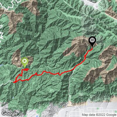
There's a free parking lot at the start of the climb at the View Point.

The road surface is good, as much of the climb overlaps with the Glendora Mountain Road and Mt. Baldy routes
The Mt. Baldy Lodge is a great place to refill waters, grab snacks, and a good meal on the way down. The last time we rode here, the lodge had a cooler full of ice for cyclists and hikers, next to a water fountain on the outside of the building. 
Before heading out on any cycling adventure check out our Things to Bring on a Cycling Trip and use our interactive check list to ensure you don't forget anything.
If you're going to do this climb, don't miss out on the chance to spend the entire day in the Mt. Baldy area! Here are some of our favorite post-ride hangout spots:

Local Brews (☕️+🍻): Top of the Notch Restaurant. Bring gravel tires or ride the ski lifts up to this amazing lunch spot featured in Mt. Baldy (to the Notch)

ROUTE MAP

MEMBER RATING

Not Yet Rated
-
Road
-
Traffic
-
Scenery

CURRENT WEATHER

PJAMM TRIPS ADVENTURE STARTER BUNDLES

Check out PJAMM Adventure's prepackaged (self-guided) cycling trips. They will help you plan, document and conquer your next adventure.
ALL TRIPS
Browse all of our prepackaged trips and find your next adventure!
San Gabriel Mountains
United States (CA)
38 ROUTES
43 POIs
ROUTE STATS (TOTAL)
677.5
mi
DISTANCE
80,483
ft
ELEV. GAIN

NEARBY CLIMBS (0) RADIAL PROXIMITY

FROM
No Climbs Found

MEMBER REVIEWS & COMMENTS

Let us know what you thought of this climb. Signup for our FREE membership to write a review or post a comment.
Already have an account?
ROUTE MAP
PROFILE TOOL
Route Data
S.G. (%)
hide
Segment Data
hide

Climb Profile Not Found
CLIMB SUMMARY

Cycling Mt. Baldy from Highway 39 - two cyclists stand with bikes on roadside, blue sky, road ascends beyond them

Highway 39/San Gabriel Reservoir to Mt. Baldy

Ride 27 miles gaining 6,214 (1,240’ descent) at 3.5% average grade.

The true average grade after eliminating descents is 5.7%

This is one of three routes to the top of Mt. Baldy:

  • Mt. Baldy Road (traditional route): 13.1 miles at 6.7%
  • GMR to Mt. Baldy (the climb summarized on this page): 27 miles at 3.8% (7.4% w/o descents)
  • Highway 39 to Mt. Baldy: 27.3 miles at 3.5% (5.7% w/o descents)

This climb is broken into three segments: (a) Start to Glendora Ridge Road (GRR), (b) GRR to the descent into Mt. Baldy Village, and (c) Baldy Village to Mt. Baldy Village.

START TO GLENDORA RIDGE ROAD

Cycling Mt. Baldy from Highway 39 - photo collage, Glendora Ridge Road, cyclist rides on two-lane roadway, intersection of East Fork Road and San Gabriel Canyon Road

It is 10 miles with 2,090’ gained at 3.5% average gain from the start to our turn onto Glendora Ridge Road.

Cycling Mt. Baldy from Highway 39 - photo collage, stretches of two-lane mountain highway roadway, bridge, cyclist rides on roadway, bike parked on hillside looking down over mountain range

We have some interesting points of interest along this segment of the climb which begins on East Fork Road.  East Fork Road becomes Glendora Mountain Road at the big right hairpin at mile 5.2.

Cycling Mt. Baldy from Highway 39 - Julius Klein conservation Camp

We pass the Julius Klein Conservation Camp #19 at mile 2.5:

“The Julius Klein Conservation Camp opened on March 1, 1986. The camp consists of 10 CDCR personnel and 13 LACO personnel, which oversee six (6) inmate hand crews and additional in-camp support inmates. The camp is located in the Angeles National Forest near the San Gabriel River.”  California Department of Corrections

Cycling Mt. Baldy from Highway 39 - tunnel in hillside, Camp Williams

Tunnel visible on the left (if you look hard) just as we pass through Camp Williams.

Cycling Mt. Baldy from Highway 39 - cafe at Camp Williams

We pass through Camp Williams at mile 4.

We ate at the cafe in 2012, but it was closed due to COVID on our December 2020 ride.

“Campground, Mobile Home Park, Café & General Store Directly on the East Fork of the beautiful San Gabriel River.”  Camp Williams Home Page.

Cycling Mt. Baldy from Highway 39 - San Gabriel River informational board

East Fork of the San Gabriel River information board at mile 4.7 just past Camp Williams.

Cycling Mt. Baldy from Highway 39 - turn onto Glendora Mountain Road from East Fork Road

Turn onto Glendora Mountain Road from East Fork Road at mile 5.2.

Cycling Mt. Baldy from Highway 39 - road closed

If you have SAG, be sure to check if the road is open.  LA Road Closures.

Cycling Mt. Baldy from Highway 39 - PJAMM Cyclists stand at entrance of small cave on roadside

This cave is on the left just after the gate and goes back a significant distance.

GLENDORA RIDGE ROAD TO DESCENT BEFORE BALDY VILLAGE

Cycling Mt. Baldy from Highway 39 - beautiful panoramic views of sun streaming down over green mountain ridgelines

We ride on GRR for 11 miles and average only 2.1% because of roughly six descents along the way.  The roughest stretch on this segment is a 3.4 mile climb at 6% beginning at mile 14.7.

Cycling Mt. Baldy from Highway 39 -views of the San Gabriel Mountains on segment of ride along Glendora Ridge Road

There are some amazing views of the San Gabriel Mountains along segment.

At mile 21.2 we begin a descent for 0.9 miles at -7% into Baldy Village.

MT. BALDY VILLAGE TO MT. BALDY RESORT

Cycling Mt. Baldy from Highway 39 - Mt Baldy Lodge

We highly recommend you have a meal at Mt. Baldy Lodge.

They are definitely bike friendly.

We ride 5.2 miles through Mt. Baldy Village and up to the ticket booth at Mt. Baldy Resort gaining 2,217’ at 8.1% average grade.  

Cycling Mt. Baldy from Highway 39 - Mt. Baldy Post office

There is a water fountain at the Mt. Baldy Post office at mile 22.2.

Cycling Mt. Baldy from Highway 39 - bike parked next to road sign, sign for curves in road

Left turn at mile 23.8 and take on eight hairpins over the steepest segment of the climb.

There is a quarter mile at 14% and a full mile that averages 12% along this segment.

Cycling Mt. Baldy from Highway 39 - views of hairpin turn at mile 24.7 of climb

Hairpin at mile 24.7.

Cycling Mt. Baldy - cyclist on bike riding up to Mt Baldy Resort sign

Sign just before the left turn to the ski resort parking lot.

Ski resort ticket booth 4/10’s mile further