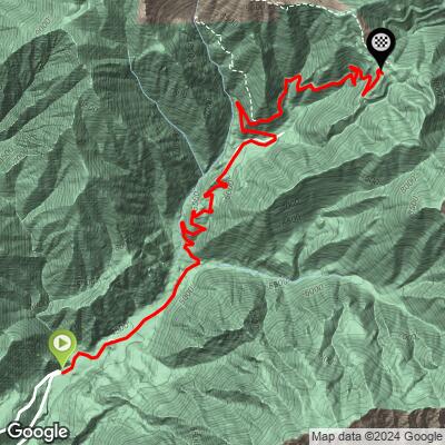
Mt. Baldy (to the Notch) Bike Climb - PJAMM Cycling

6.1
FIETS
3.4 mi
DISTANCE
1,651 ft
GAINED
9.3 %
AVG. GRADE

FULL CLIMB STATS

Page Contributor(s): Daniel Patrick, Sherman Oaks, CA, USA

INTRO

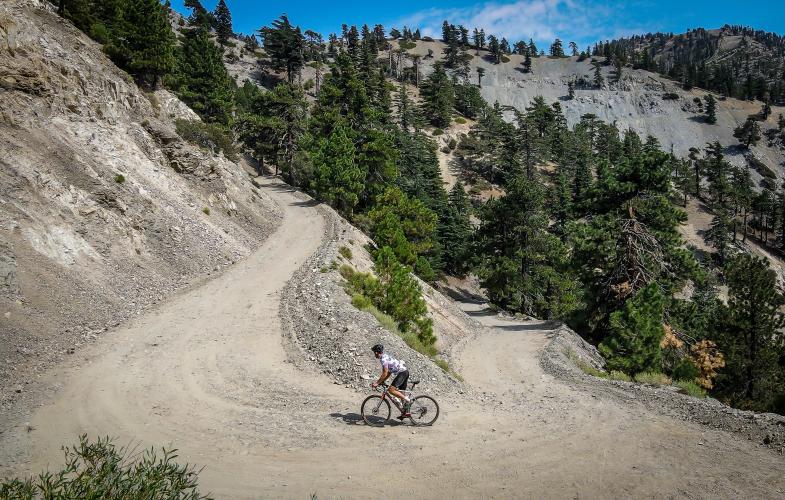
Had we been able to climb this from the bottom to the Notch on our road tires, it would have been the #1 hardest climb in California, the #5 hardest climb in the United States, and at 15.2 Fiets, in the top 50 hardest bike climbs in the world. Unfortunately, the last 100 yards are borderline impassible on anything short of knobby tires, so we have to leave it off the list.  However, if you're adventurous enough, we absolutely recommend doing this ride. Watch our full attempt of the climb here!

For details about the road climb, check out our main Mt. Baldy page.

See more details and tools regarding this climb's grade via our interactive Profile Tool.
There is a parking lot at the base of the traditional Mt. Baldy climb, as well as at the start of the gravel section.

While Mt. Baldy Road is kept up well, the last part of this climb is, well, obviously gravel. Although you can certainly do this section on 28s, it will be much more enjoyable on a gravel bike or mountain bike. 
There is water and ice provided for cyclists by the Mt. Baldy Lodge Restaurant. Stop in for a bite to eat on your way down.

There is draft beer, soda, and snacks at the Notch Restaurant at the top of the climb (that was our #1 motivation for getting to the top when we did it!)
Before heading out on any cycling adventure check out our Things to Bring on a Cycling Trip and use our interactive check list to ensure you don't forget anything.
Information Not Available

If you have any information regarding this climb, we'd like to hear from you. Click the CONTRIBUTE button to share your thoughts with us.

ROUTE MAP

MEMBER RATING

Not Yet Rated
-
Road
-
Traffic
-
Scenery

CURRENT WEATHER

PJAMM TRIPS ADVENTURE STARTER BUNDLES

Check out PJAMM Adventure's prepackaged (self-guided) cycling trips. They will help you plan, document and conquer your next adventure.
ALL TRIPS
Browse all of our prepackaged trips and find your next adventure!
San Gabriel Mountains
United States (CA)
38 ROUTES
43 POIs
ROUTE STATS (TOTAL)
677.5
mi
DISTANCE
80,483
ft
ELEV. GAIN

NEARBY CLIMBS (0) RADIAL PROXIMITY

FROM
No Climbs Found

MEMBER REVIEWS & COMMENTS

Let us know what you thought of this climb. Signup for our FREE membership to write a review or post a comment.
Already have an account?
ROUTE MAP
PROFILE TOOL
Route Data
S.G. (%)
hide
Segment Data
hide

Climb Profile Not Found
CLIMB SUMMARY

Bike parked on embankment on roadside next to speed limit sign for 15 MPH, Sierra Nevada mountains beyond, evergreen trees, Mt. Baldy rode bike climb

Cycling Mt. Baldy to the summit

Ride 15.9 miles gaining 6,267’ at 7.3% average grade (7.8% climb only)

PJAMM video of the climb.

If this climb were to be ranked on our website it would be #1 California and #5 US.  However, although I negotiated the gravel all the way on 28mm tires and a road bike, it is not really manageable enough to justify ranking it as the #1 California climb.  However, I strongly suggest you do this ride if you get the chance - perhaps on a gravel bike with big knobby tires.  This is a very challenging and fun climb.

Two PJAMM Cyclists in yellow jerseys stand with their bikes at the intersection of Mt. Baldy Road and N. Mills Avenue

Begin at the customary Mt. Baldy start - intersection of Mt. Baldy Road and N. Mills Ave.

Cycling Mt. Baldy - National Parks Service sign for Angeles National Forest

Enter Angeles National Forest (est. 1908; 655,387 acres) at mile 2.6.

Open ...Open ...

PJAMM Cyclists ride through two 50 to 100 yard tunnels

There are two 50-100 yard tunnels at mile 5.2 to 5.4

Photo collage of Mt. Baldy Lodge Restaurant - a bike friendly restaurant along the route

Mt. Baldy Lodge Restaurant is a MUST!!

They are extremely bike friendly, even providing ice to cyclists (photo bottom left).

Cyclist rides on road past sign for Mt Baldy (left) and Ice House Canyon (right)

Bear left and stay on Mt. Baldy Road at mile 9.7 where the hairpins begin.

intersection at mile 12.4 onto Falls Road

Sharp left at mile 12.4 onto Falls Road.

Turn left just before the road pitches up towards the Mt. Baldy sign, at the top of the traditional Mt. Baldy climb.

Cyclist hoists bike over a closed gate at mile 12.8 to continue riding on road that is closed to automobile traffic

Gate at mile 12.8 - it is permissible to ride your bike on this road. 

Pavement ends and gravel road begins

Gravel begins at mile 13 and is 2.8 miles at 9.2% average grade.

photo collage shows the 2.8 mile segment of gravel road on the Mt. Baldy bike climb

Photo collage shows PJAMM Cyclist riding up the 2.8 mile segment of gravel road on the Mt. Baldy bike climb

Photo collage shows drone photos of PJAMM Cyclist riding up the 2.8 mile segment of gravel road on the Mt. Baldy bike climb

Photo collage shows drone photo footage of PJAMM Cyclist riding up the 2.8 mile segment of gravel road on the Mt. Baldy bike climb

Photo collage shows the climb finish in the distance, points out Top of the Notch

Finish as seen 2.3 miles and 9.3% from the finish at Top of the Notch.

Loose gravel on a narrow alpine mountain roadway, Bike laying down on side of gravel roadway

Walk about 50 yards beginning at mile 15.4.

We recommend you use mountain bike pedals and shoes for this one.

While it is a challenge getting to the top, it’s a bit painful getting back down on a road bike - just sayin . . .  

Photo collage shows Top of the Notch, restaurant, Mt. Baldy resort

Top of the Notch - beer served here. 🍻🍻

PJAMM Cyclist Daniel Patrick stands at summit of Mt. Baldy bike climb with his Trck Domane SL6 bike

Daniel Patrick’s bike for the ride up to the top.

32mm tires on a Trek Domane SL6.