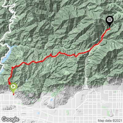
Glendora Mountain Road Bike Climb - PJAMM Cycling

7.3
FIETS
26.9 mi
DISTANCE
6,671 ft
GAINED
3.8 %
AVG. GRADE

FULL CLIMB STATS

INTRO

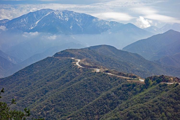
Cycling Glendora Mountain Road: We believe GMR is the most scenic bicycle climb in southern California. This is the more scenic route to Mt. Baldy Resort and has much less traffic than the Mt. Baldy Road route to the top. Often, the gate is closed near the beginning of the climb and you encounter zero vehicular traffic on the ride. However, beware of descending cyclists because this is one of the most popular bike climbs in Southern California.  Google Maps has a marker at the start of the climb named "Best Bike Road in the US."  If you type into Google Maps search menu "Best Bike Road in the US," the map will zoom in on the start of this climb.  
Do not be deceived by the low 3.8% average grade on this climb.  There are nine descents along the 22 mile initial segment of this climb on Glendora Mountain and Glendora Ridge Roads that range from 0.35 to 0.75 miles and account for 1,240' of descent.  The true grade of this climb with descent excluded is 6%.  Tack on the 1,240' of climbing on the return part of the route and you are climbing nearly 8,000' on this 54 mile out-and-back. 20% (5.3 miles) are descent, 27% (7.2 miles) are at 0-5%, 47% (12.6 miles) at 5-10% and 6.5% (1.8 miles) are at 10-15%.  

The steepest quarter mile on this climb is 13.3% as you approach the Mt. Baldy Resort sign.  The steepest mile is in the lower hairpin section after you ride through Mt. Baldy Village and is 10.4%.   more details and tools regarding this climb's grade via the “Profile Tool” button above.


Roadway:  The road is in great shape and the descent along serpentine Glendora Ridge Road and Glendora Mountain Road is extremely fun. 

Traffic:  There is minimal traffic on GMR/GRR, but when the road is open, you may get speeding motorcycles drawn to the route because of its gradual curves which are as fun for motorcycles on the up and down as the descent is for cyclists.  Often the road is closed to motor vehicles during the winter and sometimes during the non-winter months. You can check road closures (for motor vehicles - on a bike you just hop the gate) here:  LA County Road Closures.

Parking:  We always park at the start of the climb - Streetview.
Remember, you finish this climb at a ski resort over 5,000' higher than your starting point so plan accordingly - it can be very cold at the top at times other than the summer.  Review PJAMM's Weather Tool for the summit forecast to fully prepare for your trip. 
Before heading out on any cycling adventure check out our Things to Bring on a Cycling Trip and use our interactive check list to ensure you don't forget anything.
We enjoy eating at the Mt. Baldy Lodge on our descent - it is very cycling friendly - Map; Street View.

You could stay in Ontario, near the start of the climb. Additionally, the Mt. Baldy ski area has many options for private vacation rentals and cabins for those who want a mountain vacation.

ROUTE MAP

MEMBER RATING

Difficulty: Strenuous
4.5
Road
4
Traffic
4.5
Scenery

CURRENT WEATHER

PJAMM TRIPS ADVENTURE STARTER BUNDLES

Check out PJAMM Adventure's prepackaged (self-guided) cycling trips. They will help you plan, document and conquer your next adventure.
ALL TRIPS
Browse all of our prepackaged trips and find your next adventure!
San Gabriel Mountains
United States (CA)
38 ROUTES
43 POIs
ROUTE STATS (TOTAL)
677.5
mi
DISTANCE
80,483
ft
ELEV. GAIN

NEARBY CLIMBS (0) RADIAL PROXIMITY

FROM
No Climbs Found

MEMBER REVIEWS & COMMENTS

Let us know what you thought of this climb. Signup for our FREE membership to write a review or post a comment.
Already have an account?

Aug 15, 2021
difficulty: Strenuous
scenery: 5
traffic: 4
road: 4
Aug 15, 2021
scenery: 5
traffic: 4
road: 4
A breathtaking climb, with the option for making it even more challenging by going to the ski lift start up Mt. Baldy. Definitely rehydrate once you get into the village. The last stretch up to the ski lift was soul-crushing, and the views pale to those seen along the way on GMR / GR, but if you've made it this far and have never "finished" the climb, it's worth doing. GMR & GRR are stunning no matter the time of day.
Jun 20, 2021
difficulty: Challenging
scenery: 4
traffic: 4
road: 5
Jun 20, 2021
scenery: 4
traffic: 4
road: 5
Limited traffic with some nice views along the way. This is a long climb but it has a 4-5 downhill sections which give you a break as you climb. In the village you can refill your water bottles at Mt. Baldy Lodge Restaurant before the steeper section to the top of Mt. Baldy. They have a water refill station outside as well as a cooler with ice for all the cyclists. There is a also a bathroom at the visitor center across the street. The switchbacks up to the Mt. Baldy sign get steep but then the final stretch to the ski lifts at 7% feels easy! Enjoy the views!
ROUTE MAP
PROFILE TOOL
Route Data
S.G. (%)
hide
Segment Data
hide

Climb Profile Not Found
CLIMB SUMMARY

Cycling Glendora Mountain Road --

PJAMM Cycling’s choice for the most scenic cycling climb in Southern California.

California Top 10 Most Scenic Bike Climb

Climb summary by PJAMM’s John Johnson.

This is one of three routes to the top of Mt. Baldy:

  • Mt. Baldy Road (traditional route) - 13.1 miles at 6.7%
  • GMR to Mt. Baldy (the climb summarized on this page) - 27 miles at 3.8% (7.4% w/o descents)
  • Hwy 39 to Mt. Baldy - 27.3 miles at 3.5% (5.7% w/o descents)

Cycling GMR - Ride 27 miles gaining 6,645’ at 3.8% average grade.

The true grade after eliminating descents is 7.4%.

This is the more scenic alternative to the Mount Baldy Road route.  This version of the Mount Baldy bike climb begins at the corner of E. Sierra Madre Avenue and Glendora Mountain Road in Glendora, California.

Bike climb Glendora Mountain Road - The beginning of bike climb up Glendora Mountain Road - street sign

This bike climb is not a Top 100 US climb because it has 1,115' of descent, taking it out of the "nearly all" continuous climb category. It would rank #97 on the Top 100 US list if the descent were eliminated.  In other words, it is still a tough climb.  GMR, as it is referred to in Southern California, begins its ascent between Mt. Baldy Road to the East and Highway 39 (Dawson Saddle and Crystal Lake) to the West.  This climb shares its last 4.5 miles with the Mt. Baldy climb.

Before heading out to climb Glendora Mountain Road, be sure to rely on our list of Things to Bring on a Cycling Trip, and use our interactive checklist to ensure you don't forget anything.

PJAMM cyclist riding bike up Glendora Mountain Road from Glendora CA

Enter Angeles National Forest (655,387 acres; est. 1908)

Bike climb on GMR - view of roadway and ridgeline

Glendora Mountain Ridge as seen from Morris Reservoir on way to Dawson Saddle/Crystal Lake.

GMR is upper center of photo.

\Bike climb Glendora Mountain Road - aerial drone photo of Morris and San Gabriel Reservoirs and Glendora Mountain Road

This climb is in the San Gabriel Mountains of the Pacific Coast Range.

Bike climb on GMR - view of roadway and ridgeline

GMR ridgeline - Mt. Baldy center-right of photo.

Exceptional views of the surrounding San Gabriel Mountains.

Bicycle ride Glendora Mountain Road - PJAMM cyclist on bike on road at merge of Glendora Mountain Road and Glendora Ridge Road. 

From November through March the surrounding mountains are often dusted (or covered) with snow.

Bicycle ride Glendora Mountain Road - PJAMM cyclist on bike on road at merge of Glendora Mountain Road and Glendora Ridge Road.

Veer right onto Glendora Ridge Road from GMR at mile 9.7

Horse Canyon Saddle.

Cyclist at stop sign at Mt Baldy Village coming from Glendora Mountain Road 

Enter Mt. Baldy Village and merge onto Mt. Baldy Road at mile 21.7.

We highly recommend Mt. Baldy Lodge

Great atmosphere and quite cycling friendly.

There is a water fountain at the Mt. Baldy Post office at mile 21.8

Cycling Glendora Mountain Road - Mt. Baldy Lodge

Mt. Baldy Village -- mile 22.


One of the 12 switchbacks on the last three miles.

Cycling Mt. Baldy - cyclist on bike riding up to Mt Baldy Resort sign

Riding through hairpin #2.

Biking Glendora Mountain Road - road, mountain and bear crossing sign

OK -- we are only a few miles from LA, but it gets rural quick.

Bicycle ride Glendora Mountain Road - coyote on side of road

We have seen no bears on our 8 trips up this climb, but . . .  

. . . we did see a coyote August, 2019

Cycling Glendora Mountain Road - cyclist on bike riding up to Mt Baldy Resort sign

Sign just before the left turn to the ski resort parking lot.

Bike climb Glendora Mountain Road - cyclist riding past 16% grade sign

The ¼ mile leading to the Mt. Baldy sign is the steepest of the entire climb (14% average).

cycling Glendora Mountain Road - PJAMM cyclist on bike on road with center line and mt baldy resort sign

Final push to the sign - only ½ mile at 3% from there.

Cyclists at the finish of Mt Baldy and Glendora Mountain Climb - AMGEN California finish.

Cycling Mt. Baldy - cyclist on bike riding up to Mt Baldy Resort sign

That’s a wrap!

AMGEN TOUR OF CALIFORNIA


Andrew Talansky wins GMR/Mt. Baldy Stage 5 of the 2017 Tour of California

Photo:  SoCalCycling.com

Queen Stage (Stage 6) 5-17-19 - Glendora Ridge Road

After Stage 6 of the 2019 Tour of California is complete, Mt. Baldy (GMR always included) will have been a stage finish five of the 13 years the Tour has been held (each year since 2006).  The route on the Mt. Baldy stage is always the same route:

The route for all five ToC GMR/Baldy mountain-top finishes (2019 Map).

The Tour of California Route is generally:

  • Start in Ontario and ride to Mt. Baldy Road;
  • Climb Mt. Baldy Road to the village of Mt. Baldy;
  • Turn left at Mt. Baldy onto Glendora Ridge Road;
  • Ride Glendora Ridge Road to its intersection with Glendora Mountain Road;
  • Turn right onto Glendora Mountain Road and ride to East Fork Road;
  • Ride East Fork Road to Highway 39;
  • Ride Highway 39 south towards Azusa, past San Gabriel Reservoir to Sierra Madre Road;
  • Ride Sierra Madre Road to Glendora Mountain Road;
  • Climb Glendora Mountain Road to Glendora Ridge Road on to the village of Mt. Baldy;
  • Turn onto Mt. Baldy Road and continue five miles to the finish of the climb at Mt. Baldy Resort.

Chris Horner wins 2011 ToC but Levi gets Stage 7!

Robert Gesink wins in sprint finish with Darwin Atapuma.

After Mt. Hamilton (in Northern California’s East Bay/Silicon Valley), Mt. Baldy/GMR has been included in more Amgen Tours than any other mountain climb.

2015 -- Jullian Alaphilippe.

Stage Profile for all Glendora Mountain / Mt. Baldy ToC stages.

Summary from 2015 Tour of California Website:

            “Route Information: May 16, 2015 - Stage 7 Finish


The climb up to Mt. Baldy is an integral part of the Amgen Tour of California’s nine-year history. Since 2011, when it was first introduced as the race’s first true mountaintop finish, the steep switchbacks up to the Mt. Baldy Ski Area at 6,500 feet elevation have served as the deciding factor in crowning the overall champion. Due to overwhelming demand from the fans, Mt. Baldy is back for the Amgen Tour of California 10th Anniversary after a two-year hiatus!
Mt. Baldy is located 45 miles from downtown Los Angeles and is a popular location for hikers, sightseers and cyclists. During autumn, spring, and summer you will find hundreds to thousands of outdoor enthusiasts traveling Mt. Baldy every week to summit the tallest peak in Los Angeles County, Mt. San Antonio (Elevation 10,068 feet), which is accessible from a trail network originating at the Mt. Baldy Ski Area. For those who prefer a two-wheeled adventure, cyclists from far and wide visit Mt. Baldy to climb the challenging switchbacks, which ascend over 2,000 in only 4.3 miles (9% average gradient). In the winter months Mt. Baldy is known for its steep ski terrain and easy access from the big city below”  (see also:
2019 ToC summary of Baldy Stage).

SOUTHERN CALIFORNIA’S TOP BIKE CLIMBS

Top Southern California Road Bike Climbs - clockwise from top left to middle:

Nate Harrison Grade, San Diego; Gibraltar Road, Santa Barbara; Palomar Mountain, San Diego

Glendora Mountain Road, Los Angeles; Mt. Baldy, Los Angeles

Access to full Climb Summary requires a PJAMM Cycling PRO Membership!

It takes less than a minute to sign up & with your PRO membership you can:
  • Rate climbs, post comments and share your experiences on any of our climb pages
  • Create bucket lists of climbs & mark the dates you complete them
  • Weather data for all climbs - Start & Finish
  • Upload photos to your member page to customize your PJAMM Cycling experience
  • Utilize all of our interactive tools - Profile & Routes in Area
  • Download climb route .gpx files
LEARN MORE
SIGN UP

Already have an account? LOG IN HERE