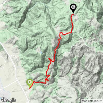
4.3
FIETS
4.9 mi
DISTANCE
1,925 ft
GAINED
7.4 %
AVG. GRADE
FULL CLIMB STATS
INTRO
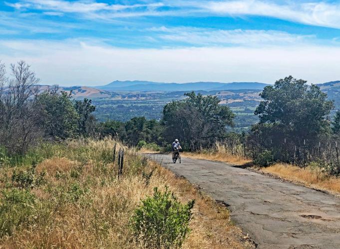
This is a fairly remote and challenging climb that ranks #7 in Sonoma County. Cavedale Road is our favorite bike climb in the southeastern section of Sonoma County. The roadway was repaved in 2022 and is now pristine!! The views along much of the first half of the ride are very scenic, with spectacular views of the Sonoma Valley and its vineyards far below. This road gets it's name form a small cave about 3/4 of the way up. If you ride around a holiday there usually is some special decoration inside to lighten up this difficult climb. The last 1/4 mile is rolling down hill to the fire station and drops you at the junction of Dry Creek and Trinity road.
This climb has a 7.3% average grade with 70% in the 5-10% range. The steepest quarter-mile is 10.6% and steepest mile 9%.
See more details and tools regarding this climb's grade via the “Profile Tool” button above.
Roadway: Narrow two lanes in poor condition with some potholes.
Traffic: Minimal.
Parking: We normally park in Glen Ellen and do a loop that includes Cavedale. You can park along the left side of the road just after turning off Highway 12 - Map; Street View.
Provisions: No food along the route. There is water at the fire station at the intersection of Cavedale ant Trinity Roads a couple miles past the finish of this climb - Map; Street View. There are also food, meals, and beverages at restaurants or the two stores in Glen Ellen 6.2 miles southwest of the climb finish.
Before heading out on any cycling adventure check out our Things to Bring on a Cycling Trip and use our interactive check list to ensure you don't forget anything.
A nice loop is Glen Ellen - Climb Cavedale - Descend Trinity Road - Back to Glen Ellen - 17 miles 2,340' (Map).
If you have travelled to Sonoma County to cycle or have any questions concerning cycling in the North Bay, you are welcome to contact John Johnson - Founder | CEO of PJAMM Cycling at john@pjammcycling.com with your questions about the area. He grew up and lives in Sonoma County and has a good knowledge of cycling in this region. There are several hotel options in nearby Santa Rosa to choose from if cycling in this area.
ROUTE MAP
MEMBER RATING
CURRENT WEATHER
PJAMM TRIPS ADVENTURE STARTER BUNDLES
Check out PJAMM Adventure's prepackaged (self-guided) cycling trips. They will help you plan, document and conquer your next adventure.
NEARBY CLIMBS (0) RADIAL PROXIMITY
FROM No Climbs Found
MEMBER REVIEWS & COMMENTS
Let us know what you thought of this climb. Signup for our FREE membership to write a review or post a comment.
Already have an account?
LOG IN HERE
lirizar1
Beautiful views along the climb. Road pavement is average but gets worse at the top (PJAMM said not to descend this and he is absolutely right — go down on Trinity, the road has been newly paved!). There are three steep but very short kickers towards the top but besides that a pretty consistent grade up. Enjoy!


