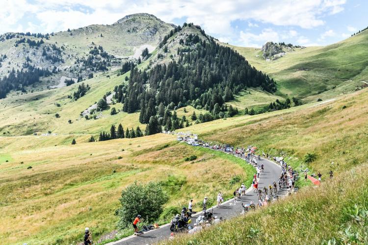
1.3
FIETS
131.7 mi
DISTANCE
13,508 ft
GAINED
0.4 %
AVG. GRADE
FULL CLIMB STATS
INTRO
Climbs, cols, and côtes of Stage 11 (Mountain):
Col de Neronne - 2.4 miles at 8.8%
Puy Mary - 5.7 miles at 6.9%
Col de Pertus - 2.8 miles at 8.5%
Col de Font de Cere - 3.8 miles at 4.9%
Click on "Full Summary" to see a full summary of Tour de France Stage 11, or see our 2024 Tour de France page. See also All Time Hardest Climbs of the Tour de France.
Côte de Fontaine-de-Vaucluse (category 4): 6.3% average grade, 0 descent; 35% of the climb is at 0-5%, 49% at 5-10%, and 16% at 10-15%; the steepest 500 meters is 10.1%.
Côte de Gordes (category 4): 5.6% average grade, 0 descent; 21% of the climb is at 0-5% and 79% at 5-10%; the steepest 500 meters is 7.5%.
Col de la Liguière (category 1): 6.5% average grade, 0 descent; 15% is at 15% and 85% is at 5-10%; steepest 500 meters is 8.4%.
Mont Ventoux - Sault (category 1): 4.9% average grade; 47% at 0-5%, 50% at 5-10% and 2% at 10-15%.
Mont Ventoux - Bedoin (HC): 8.5%, 0 descent; 3% is at 0-5%, 75% is at 5-10%, and 22% is at 10-15%; steepest 500 meters is 11.1%, steepest 1 km is at 10.7%; and steepest 2 km is at 10%.
Information Not Available
If you have any information regarding this climb, we'd like to hear from you. Click the CONTRIBUTE button to share your thoughts with us.
Information Not Available
If you have any information regarding this climb, we'd like to hear from you. Click the CONTRIBUTE button to share your thoughts with us.
Before heading out on any cycling adventure check out our Things to Bring on a Cycling Trip and use our interactive check list to ensure you don't forget anything.
Information Not Available
If you have any information regarding this climb, we'd like to hear from you. Click the CONTRIBUTE button to share your thoughts with us.
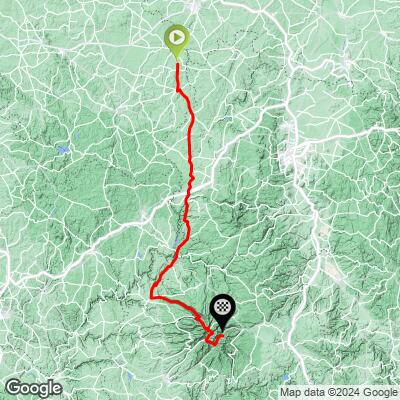
ROUTE MAP
MEMBER RATING
CURRENT WEATHER
PJAMM TRIPS ADVENTURE STARTER BUNDLES
Check out PJAMM Adventure's prepackaged (self-guided) cycling trips. They will help you plan, document and conquer your next adventure.
(1,2,3) 2023 Tour de France: The Grand Départ
Spain, France
16 ROUTES
2 POIs
ROUTE STATS (TOTAL)
359.6
mi
DISTANCE
26,313
ft
ELEV. GAIN
(13,14,15,16,17,18) 2023 Tour de France: The Alps
France, Switzerland
32 ROUTES
3 POIs
ROUTE STATS (TOTAL)
525.7
mi
DISTANCE
56,233
ft
ELEV. GAIN
(19,20) 2023 Tour de France: The Jura Mountains
France, Switzerland
9 ROUTES
2 POIs
ROUTE STATS (TOTAL)
192.6
mi
DISTANCE
17,443
ft
ELEV. GAIN
(21) 2023 Tour de France: Finale
France
1 ROUTES
1 POIs
ROUTE STATS (TOTAL)
73.4
mi
DISTANCE
2,145
ft
ELEV. GAIN
(4,7,8) 2023 Tour de France: The Sprinter's Stages
France
4 ROUTES
1 POIs
ROUTE STATS (TOTAL)
344.3
mi
DISTANCE
12,417
ft
ELEV. GAIN
(5,6) 2023 Tour de France: The Grand Pyrenees
France
8 ROUTES
1 POIs
ROUTE STATS (TOTAL)
193.7
mi
DISTANCE
23,064
ft
ELEV. GAIN
NEARBY CLIMBS (0) RADIAL PROXIMITY
FROM No Climbs Found
MEMBER REVIEWS & COMMENTS
Let us know what you thought of this climb. Signup for our FREE membership to write a review or post a comment.
Already have an account?
LOG IN HERE


