1.2
FIETS
9.5 mi
DISTANCE
2,174 ft
GAINED
2.8 %
AVG. GRADE
FULL CLIMB STATS
INTRO
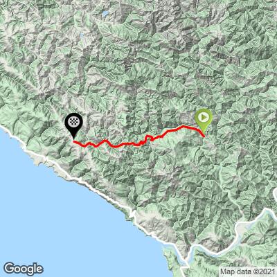
The east side of Fort Ross Road (beginning in Cazadero) is much milder than it's big brother Fort Ross West (#6 on the Tri-County list - 2.4 miles at 10.9% average grade). The 5.2 mile initial climb is followed by a 1.5 miles 523' descent, followed by roughly 1 mile of flat riding, ending with a 1.4 mile 8.1% punch to the intersection of Meyers Grade and Fort Ross Roads.
See more details and tools regarding this climb's grade via our interactive Profile Tool.
Information Not Available
If you have any information regarding this climb, we'd like to hear from you. Click the CONTRIBUTE button to share your thoughts with us.
Information Not Available
If you have any information regarding this climb, we'd like to hear from you. Click the CONTRIBUTE button to share your thoughts with us.
Before heading out on any cycling adventure check out our Things to Bring on a Cycling Trip and use our interactive check list to ensure you don't forget anything.
Information Not Available
If you have any information regarding this climb, we'd like to hear from you. Click the CONTRIBUTE button to share your thoughts with us.
ROUTE MAP
MEMBER RATING
CURRENT WEATHER
PJAMM TRIPS ADVENTURE STARTER BUNDLES
Check out PJAMM Adventure's prepackaged (self-guided) cycling trips. They will help you plan, document and conquer your next adventure.
NEARBY CLIMBS (0) RADIAL PROXIMITY
FROM No Climbs Found
MEMBER REVIEWS & COMMENTS
Let us know what you thought of this climb. Signup for our FREE membership to write a review or post a comment.
Already have an account?
LOG IN HERE


