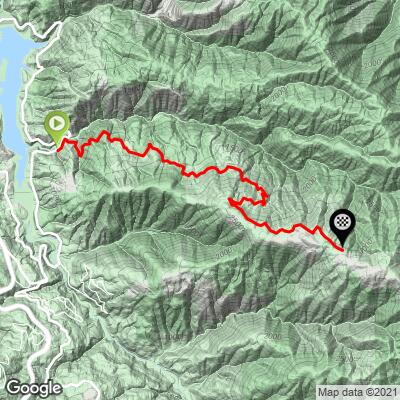
Soda Springs Road Bike Climb - PJAMM Cycling

5.8
FIETS
5.4 mi
DISTANCE
2,337 ft
GAINED
8.2 %
AVG. GRADE

FULL CLIMB STATS

INTRO

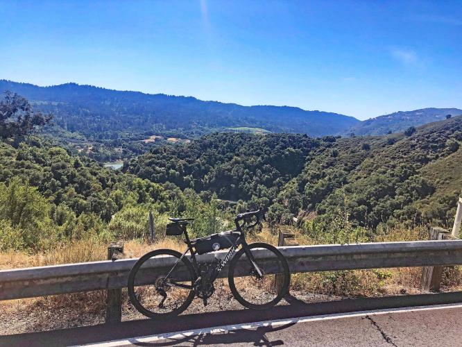
This is one of four excellent bike climbs near Lexington Reservoir off of Highway 17. This climb runs near the Sierra Azul Open Space Preserve, home to Santa Clara County's greatest bike climbs. 

"Soda Springs Road is a steady and severe dead end climb between the towns of Los Gatos and Santa Cruz in the Bay Area. Trees close in quickly as the grade slowly ramps up over the initial section. Once up to its average the slope is unrelenting and fairly steady but never severely steep. A very narrow and twisty road takes you through a hillside neighborhood to its dead end top which can be a welcome sight. Due to its twisty routing Soda Springs is a somewhat difficult descent as well." (This quote is presented with the approval of John Summerson, from his book, The Complete Guide to Climbing (by Bike) in California, pg. 243.)
Average grade is 8.2% with 0 descent. 71% of the climb is at grade 5-10% and 21% is at 109-15%.  The steepest quarter-mile running at 10%, and steepest full mile at 9.1%.  

See more details and tools regarding this climb's grade via the “Profile Tool” button.
Roadway:  Narrow and in moderate condition with some rough spots - be wary on the descent. 

Traffic:  Minimal.

Parking:  At climb start - Map;  Street View.  Or park across Highway 17 at the start of the Black Road climb 4 miles away (map) and include Soda Spring Road in your climb grouping for the day - Map; Street View.
Provisions:  There are no spots for food or water on the climb - the closest provisions are at Redwood Estates Store (Google Map + Reviews) 4.6 miles south in Redwood Holy City Estates (Route MapStreet View or Los Gatos 5.4 miles north (Route Map). 
Before heading out on any cycling adventure check out our Things to Bring on a Cycling Trip and use our interactive check list to ensure you don't forget anything.
There are several great climbs in the immediate vicinity of Soda Springs Road which can be done on the same ride - (here is a nice 4 climb route with 41 miles and 7,920' gained - Route Map).  

You can stay in nearby Los Gatos which has a few hotel options or if you are planning a longer visit there are many cottages and villas you can rent in the area.

ROUTE MAP

MEMBER RATING

Not Yet Rated
-
Road
-
Traffic
-
Scenery

CURRENT WEATHER

PJAMM TRIPS ADVENTURE STARTER BUNDLES

Check out PJAMM Adventure's prepackaged (self-guided) cycling trips. They will help you plan, document and conquer your next adventure.
ALL TRIPS
Browse all of our prepackaged trips and find your next adventure!
San Francisco Bay Area
United States (CA)
25 ROUTES
30 POIs
ROUTE STATS (TOTAL)
487.9
mi
DISTANCE
65,482
ft
ELEV. GAIN

NEARBY CLIMBS (0) RADIAL PROXIMITY

FROM
No Climbs Found

MEMBER REVIEWS & COMMENTS

Let us know what you thought of this climb. Signup for our FREE membership to write a review or post a comment.
Already have an account?
ROUTE MAP
PROFILE TOOL
Route Data
S.G. (%)
hide
Segment Data
hide

Climb Profile Not Found
CLIMB SUMMARY

Climbing Soda Springs Road by bike - start, roadway signs, road,

Cycling Soda Springs Road Santa Clara County

Ride 5.5 miles to elevation 3,048 gaining 2,620’ at 8.2%

Climb summary by PJAMM’s John Johnson.

Soda Springs Road is the one of four excellent Lexington Reservoir climbs that begins on the reservoir side (east) of Highway 17.  This one is a true single lane road which is in great shape and sees very little traffic, other than by cyclists (2,320 attempts on Strava as of March 27, 2016) and the few residents along the route.  The climb is a bear and #4 in the Santa Clara/Santa Cruz County areas.

Before heading to Santa Cruz County on your cycling adventure, be sure to rely on our list of Things to Bring on a Cycling Trip, and use our interactive checklist to ensure you don't forget anything.

Cycling Soda Springs Road - road sign, cyclists, roadway

The climb is consistently steep throughout -

Never more than 12%, never less than 7%,

The steepest quarter-mile is 10%.

cyclist rides on roadway at intersection on Soda Springs road, road signs warn of winding roads next 6 miles, PJAMM Cycling logo in corner

Lower portion of the climb.

Cycling Soda Springs, Road, Los Gatos, California - photo collage, views along the climb from miles 2 through 4, bike parked between large eucalyptus trees, bike leaning against stone tower, PJAMM Cycling logo in corner

Miles 2 through 4.

Cycling Soda Springs, Road, Los Gatos, California - climb ends at a gate with sign reading "Private Road, No Umunhum or Thayer Access," PJAMM Cyclist stands with bike in front of gate

Final segment of the climb -

Climb ends at a locked gate posted “Private Road - No Umunhum or Thayer Access”

Cycling Soda Springs, Road, Los Gatos, California - bike parked next to colorful flowers on roadside

Soda Springs in the spring.

Unfortunately, although the road continues from its paved finish, the gate is locked and our Santa Clara cycling consultant answers my question about continuing on past the gate as follows:

There is a locked gate at the top of Soda Springs, unfortunately.  I've never been past the gate, sometimes I ignore "private road" signs but I don't like to jump gates.  There are houses near the gate, as you climb, and it looks like there are houses near the gate on the other side, so it is likely somebody would see if you jumped the gate.  Soda Springs does come close to Mt Thayer and Mt Umunhum and I'm sure the roads probably do connect, but there are gates on both sides so I've never attempted it. I did read online some guy jumped the gates and took a mountain bike the whole way, but it sounded sketchy. So unfortunately, I don't know any way from Soda Springs to Mt Umunhum.

A spectacular climbing day:  Black - Gist - Thompson - Montevina - Soda Springs Roads (Map) - essentially no traffic and quiet riding/climbing of 41 miles, gaining nearly 8,000'.  ​

​Roadway Surface and Traffic Report:  This is a true one lane ride (sometimes just barely that) which is in good shape with next to zero traffic the entire climb - this is a safe climb.​

That’s a wrap!!