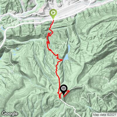
High Knob Bike Climb - PJAMM Cycling

5.2
FIETS
4.6 mi
DISTANCE
1,994 ft
GAINED
8.2 %
AVG. GRADE

FULL CLIMB STATS

Page Contributor(s): Dan Razum, Campbell, CA, USA.

INTRO

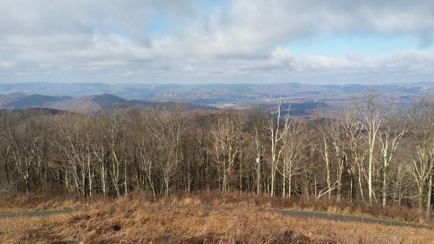
"High Knob is among the steepest climbs in the Southeast.  The first 2 miles are the most difficult and along a very narrow road through a thick tunnel of trees.  There is a small neighborhood at the bottom but traffic is light.  Soon after beginning the ascent you encounter a series of tight double switchbacks which will get your undivided attention as they are over double digit grade and contain the maximum grade on the hill.  As you approach the top the grade eases slightly and the summit is unmarked but obvious.  You can continue riding beyond the listed top for a short distance.  Any route in this area is through thick and scenic woods." This quote is presented with the approval of John Summerson, from his book, The Complete Guide to Climbing (by Bike), 2nd Edition, pg. 122.)

See more details and tools regarding this climb's grade via our interactive Profile Tool.
Information Not Available

If you have any information regarding this climb, we'd like to hear from you. Click the CONTRIBUTE button to share your thoughts with us.

Information Not Available

If you have any information regarding this climb, we'd like to hear from you. Click the CONTRIBUTE button to share your thoughts with us.

Before heading out on any cycling adventure check out our Things to Bring on a Cycling Trip and use our interactive check list to ensure you don't forget anything.
Information Not Available

If you have any information regarding this climb, we'd like to hear from you. Click the CONTRIBUTE button to share your thoughts with us.

ROUTE MAP

MEMBER RATING

Not Yet Rated
-
Road
-
Traffic
-
Scenery

CURRENT WEATHER

PJAMM TRIPS ADVENTURE STARTER BUNDLES

Check out PJAMM Adventure's prepackaged (self-guided) cycling trips. They will help you plan, document and conquer your next adventure.
ALL TRIPS
Browse all of our prepackaged trips and find your next adventure!
Smoky Mountain National Park
United States (NC,TN)
17 ROUTES
31 POIs
ROUTE STATS (TOTAL)
181.8
mi
DISTANCE
34,253
ft
ELEV. GAIN
The Blue Ridge Parkway (North)
United States (NC,TN,VA)
38 ROUTES
70 POIs
ROUTE STATS (TOTAL)
716.5
mi
DISTANCE
75,697
ft
ELEV. GAIN
The Blue Ridge Parkway (South)
United States (NC,TN,VA)
30 ROUTES
63 POIs
ROUTE STATS (TOTAL)
690.7
mi
DISTANCE
74,180
ft
ELEV. GAIN

NEARBY CLIMBS (0) RADIAL PROXIMITY

FROM
No Climbs Found

MEMBER REVIEWS & COMMENTS

Let us know what you thought of this climb. Signup for our FREE membership to write a review or post a comment.
Already have an account?
ROUTE MAP
PROFILE TOOL
Route Data
S.G. (%)
hide
Segment Data
hide

Climb Profile Not Found
CLIMB SUMMARY

High Knob Climb Summary


View from the top of High Knob

Thanks to our friend Dan Razum from Campbell, California for his contributions to the Climb Page and this write-up:

The climb starts at the intersection of Alt58 and 619 in Norton, VA.


Start of Climb.

The climb starts off immediately, so it's a good idea to ride around Norton a little to warm up first. Route 619 is narrow with no shoulder, mostly 2 lanes but with a few short stretches that are only 1 lane wide. The surface is good and quite smooth.


Generally two lanes, but narrow.

There are many sharp turns and switchbacks, which makes for a technical descent.  There are also some pretty steep sections but luckily those sections aren't too long, you can power through them. Even though the road is narrow, steep and

twisty, it felt safe; the little traffic that was there was slow and courteous.


Some nice hairpins on the climb.

Halfway up the climb is the turnout to Flag Rock Overlook.  A small road leads about a half a mile from 619

to the overlook.  It is well worth riding to the overlook, there is a beautiful view of the city of Norton and

the surrounding area. There is a flag on a large rock (hence the name) but you can't actually reach it, the

closest you can get is an observation deck about 200 yards away.  But the observation deck is higher than the flag,

so you have a better view than if you were at the flag itself. Due to the shapes of the mountains, you cannot see

the city of Norton from the High Knob tower, so you should definitely visit the Flag Rock overlook. If you want

to do the full climb non-stop, then you can always stop at Flag Rock on the way down.


View of Norton from Flag Rock Overlook.

Continuing up the mountain, you eventually reach the high point of 619. You then turn left and continue climbing

a little further along a smaller road before turning right for the final short little climb to the High Knob tower.

There is a small paved path from the parking lot up to the tower, for handicap (and cycling!) access, so you

can ride all the way to the tower.  There are great 360 degree views from the tower but you can't see the starting

point in Norton, it is hidden by the mountain itself.


We made it!  High Knob Tower.

All in all, this a beautiful twisty climb through thick forest with great views in all directions at the top.