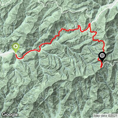
Blue Ridge Parkway to Waterrock Knob from Hwy 19 Bike Climb - PJAMM Cycling

6.7
FIETS
12.4 mi
DISTANCE
3,585 ft
GAINED
5.5 %
AVG. GRADE

FULL CLIMB STATS

Page Contributor(s): from John Summerson, The Ultimate Guide to Climbing (by bike) in the Southeast” p. 98

INTRO

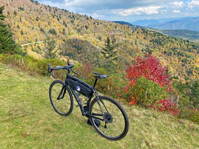
"The start of this hill is along Route 19, a narrow road from Cherokee, NC that carries some traffic at times.  It gradually gets tighter and steeper as you climb and towards the top of this stretch moves along the ridge through a few tighter turns.  At mile 7.6 turn right onto the Blue Ridge Parkway along one of the most scenic sections of climbing on earth.  This stretch is steady grade along a twisty route and thick woods.  At the top of the ridge make a left turn (straight to continue on the Parkway) for the short finishing climb toward Waterrock Knob.  There is a visitors center with parking on top with restrooms and Waterrock Knob as great views of the surrounding mountains..."  (This quote is provided with the approval of John Summerson from his book The Complete Guide to Climbing (by Bike) in the Southeast, pg. 98.)

See more details and tools regarding this climb's grade via our interactive Profile Tool.
Information Not Available

If you have any information regarding this climb, we'd like to hear from you. Click the CONTRIBUTE button to share your thoughts with us.

Information Not Available

If you have any information regarding this climb, we'd like to hear from you. Click the CONTRIBUTE button to share your thoughts with us.

Before heading out on any cycling adventure check out our Things to Bring on a Cycling Trip and use our interactive check list to ensure you don't forget anything.
Cycle the entire Blue Ridge Parkway – see PJAMM’s March 2022, 467-mile adventure on the PJAMM Adventures App: Blue Ridge Parkway. See also our Climbs of the BRP (NC to VA) and Climbs of the BRP (VA to NC).
 

ROUTE MAP

MEMBER RATING

Not Yet Rated
-
Road
-
Traffic
-
Scenery

CURRENT WEATHER

PJAMM TRIPS ADVENTURE STARTER BUNDLES

Check out PJAMM Adventure's prepackaged (self-guided) cycling trips. They will help you plan, document and conquer your next adventure.
ALL TRIPS
Browse all of our prepackaged trips and find your next adventure!
Smoky Mountain National Park
United States (NC,TN)
17 ROUTES
31 POIs
ROUTE STATS (TOTAL)
181.8
mi
DISTANCE
34,253
ft
ELEV. GAIN
The Blue Ridge Parkway (North)
United States (NC,TN,VA)
38 ROUTES
70 POIs
ROUTE STATS (TOTAL)
716.5
mi
DISTANCE
75,697
ft
ELEV. GAIN
The Blue Ridge Parkway (South)
United States (NC,TN,VA)
30 ROUTES
63 POIs
ROUTE STATS (TOTAL)
690.7
mi
DISTANCE
74,180
ft
ELEV. GAIN

NEARBY CLIMBS (0) RADIAL PROXIMITY

FROM
No Climbs Found

MEMBER REVIEWS & COMMENTS

Let us know what you thought of this climb. Signup for our FREE membership to write a review or post a comment.
Already have an account?
ROUTE MAP
PROFILE TOOL
Route Data
S.G. (%)
hide
Segment Data
hide

Climb Profile Not Found
CLIMB SUMMARY

Cycling Waterrock Knob from Highway 19, North Carolina - hiking sign for Waterrock Knob Trail, fall foliage

Cycling Waterrock Knob via Route 19

Ride 12.4 miles gaining 3,607’ at 5.5% average grade.

The last five miles of this climb are on the amazing Blue Ridge Parkway, one of the most scenic roadways in the United States.  By BRP standards, this is a moderately difficult climb with an average of 5.5% and several segments briefly reaching double digits.  The steepest quarter-mile is 8.7%, and the steepest half-mile comes in at 8.2%.

Cycling Waterrock Knob from Highway 19, North Carolina - Blue Ridge Parkway, hiking signs for Waterrock Knob trails and visitor center, BRP

“Route 19 is a narrow road that carries some traffic.  At mile 7.6 turn right onto the Blue Ridge Parkway and continue along one of the most scenic sections of climbing on earth.  At the top of the ridge make a left turn for the short finishing climb to Waterrock Knob.  There is a visitors center with parking on top with restrooms.”  (This quote is provided with the approval of John Summerson from his book The Complete Guide to Climbing (by Bike) in the Southeast,  pg. 98.)

Cycling Waterrock Knob from Highway 19, North Carolina - trail sign for Cranberry Ridge overlook, Blue Ridge Parkway, blue sky, forestation

One of several overlooks along the climb.

HIGHEST VISITOR CENTER ON THE BLUE RIDGE PARKWAY

Cycling Waterrock Knob from Highway 19, North Carolina - visitor's center at climb's summit, highest visitor's center on Blue Ridge Parkway, inside and outside of visitor's center

Visitor Center at climb finish.

Cycling Waterrock Knob from Highway 19, North Carolina - informational sign naming various peaks visible from this point

Cycling Waterrock Knob from Highway 19, North Carolina - informational sign looking out over panoramic views from BRP

Cycling Waterrock Knob from Highway 19, North Carolina - photo collage, Blue Ridge Parkway views from the hillside, forestation, PJAMM Cycling jersey, trail sing for Waterrock Knob hike

The half-mile hike to the the top of Waterrock Knob.  All Trails has more information on this hike.