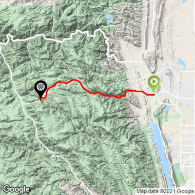
Rist Canyon East Bike Climb - PJAMM Cycling

5.8
FIETS
11 mi
DISTANCE
2,917 ft
GAINED
5 %
AVG. GRADE

FULL CLIMB STATS

Page Contributor(s): Ben Loftin, Colorado Springs, Colorado

INTRO

This is a moderately long climb out of Fort Collins that has several quarter-mile+ segments in the 10% average grade range. This is a fun climb into a mildly secluded area which has some interesting sites along the way. 
5.5% average grade. 46% of the climb is at 0-5% and 43% is at 5-10% grade.  The steepest quarter-mile is 10.9% and steepest mile 8.6%. 

See more details and tools regarding this climb's grade via the “Profile Tool” button.


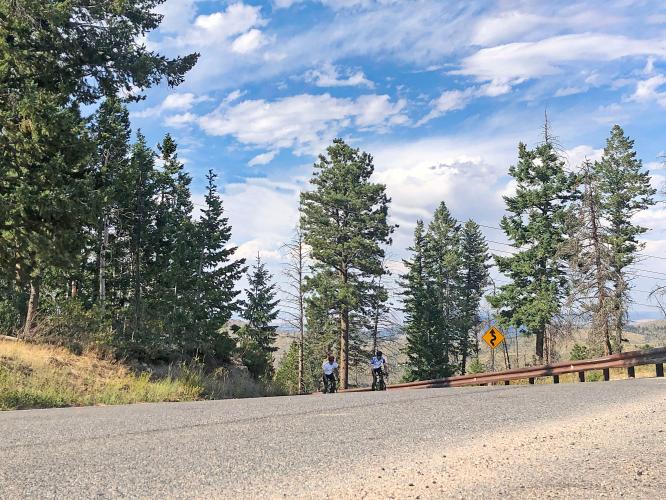
Roadway:  This is a two lane county road in good condition with a double yellow stripe and 0 to narrow shoulder.

Traffic:  Mild.

Parking:  On the side of County Road 52 East just to the west of the start (MapStreet View). 
Provisions:  None on the route.  The closest food and beverages are in Laporte two miles east (Map). 
Before heading out on any cycling adventure check out our Things to Bring on a Cycling Trip and use our interactive check list to ensure you don't forget anything.
A nice out and back would be to add Rist Canyon West - 35 miles gaining 5,150' (Map).  Also, spend a few minutes riding around Bellvue at the start, it has some interesting sites - see Full Summary.

Use the “Routes in Area” button on the menu bar to see other bike climbs in this area. 

ROUTE MAP

MEMBER RATING

Not Yet Rated
-
Road
-
Traffic
-
Scenery

CURRENT WEATHER

PJAMM TRIPS ADVENTURE STARTER BUNDLES

Check out PJAMM Adventure's prepackaged (self-guided) cycling trips. They will help you plan, document and conquer your next adventure.
ALL TRIPS
Browse all of our prepackaged trips and find your next adventure!
Colorado: Front Range
United States (CO)
20 ROUTES
46 POIs
ROUTE STATS (TOTAL)
563.5
mi
DISTANCE
73,545
ft
ELEV. GAIN
RMNP: Trail Ridge Road
United States (CO)
13 ROUTES
33 POIs
ROUTE STATS (TOTAL)
258.2
mi
DISTANCE
25,530
ft
ELEV. GAIN

NEARBY CLIMBS (0) RADIAL PROXIMITY

FROM
No Climbs Found

MEMBER REVIEWS & COMMENTS

Let us know what you thought of this climb. Signup for our FREE membership to write a review or post a comment.
Already have an account?
ROUTE MAP
PROFILE TOOL
Route Data
S.G. (%)
hide
Segment Data
hide

Climb Profile Not Found
CLIMB SUMMARY

Cycling Rist Canyon East - large cylindrical hay bales in field

Cycling Rist Canyon East

Ride 11 miles gaining 2,910’ to elevation 7,995’ at 5% average grade.

This is a moderately long climb that has several quarter-mile+ segments in the 10% average grade range.  The Steepest quarter-mile comes in the last mile of the climb and averages 11%.  The last mile is the most difficult section of the climb as it averages nearly 9% to the top.

Cycling Rist Canyon East - photo collage, PJAMM Cycling logo in corner, aerial view of PJAMM Cycling's white SAG vehicle parked next to road sign for Rist Canyon Road, aerial view of climb, bike handlebars with yellow Bellvue Store building behind, cyclists riding along straight portion of roadway, then on curved portion next to sign for 12% grade

This climb begins in the very interesting town of Bellvue.  Spend a few minutes riding around Bellvue and you will enjoy some interesting structures and artistic arrangements along the roadway.

Cycling Rist Canyon East - photo collage, PJAMM Cycling logo in corner, bike parked at various points along the climb: against fence next to yellow fire hydrant and green field, against sign for town of Bellvue, old red horse trailer, large gnarled tree, in front of yellow Bellvue store

Scenes within a few blocks of the start.

Upper left photo: Goat Hill as seen from Rist Canyon Road.

Cycling Rist Canyon East - photo collage, PJAMM Cycling logo in corner, bike parked at Stop sign in front of yellow Bellvue store, cyclists getting ready to leave from PJAMM Cycling's white SAG van, climb map and gradient

Climb begins at the intersection of Rist Canyon Road and County Route 23.

Cycling Rist Canyon East - photo collage, PJAMM Cycling logo in corner, bike parked in front of red brick building, Grange Hall, signs for Old Flowers Store and Post Office, Bellvue Senior Center

Grange Hall is on a corner of the start.

Cycling Rist Canyon East - photo collage, PJAMM Cycling logo in corner, bike parked on roadside in pastureland, rural farm buildings in distance, including old red barn and white silo

We ride through farmland along the first mile of the climb.

Bellevue is an agricultural community in the Pleasant Valley just northwest of Fort Collins.

Cycling Rist Canyon East - milk trucks parked in fields along roadway, near road signs at intersection of Rist Canyon Road and County Road 25E

We thought the seemingly abandoned old milk trucks were of scenic interest.

Cycling Rist Canyon East - PJAMM Cycling's white SAG van parked on roadside near old graffitied abandoned milk truck in field

Cycling Rist Canyon East - photo collage, PJAMM Cycling logo in corner, large cylindrical bales of hay in field, cyclist riding on roadside next to field

Cycling Rist Canyon East - photo collage, PJAMM Cycling logo in corner, vies along roadway near Bellvue and beyond, including boulder painted bright blue with dinosaur face on it, sign with info on Rist Canyon Fire Department's annual budget

These photos are representative of the interesting and fun scenery along this challenging bike climb.

Cycling Rist Canyon East - photo collage, PJAMM Cycling logo in corner, climb map and gradient profile, cyclists riding on straight portion of two-lane roadway, PJAMM Cycling's white SAG vehicle

Cycling Rist Canyon East - rear-view mirror view of two cyclists approaching SAG vehicle

Cycling Rist Canyon East - photo collage, PJAMM Cycling logo in corner, signs for 12% grade, Rist Canyon, Garmin device

Finish the climb at 7,938’, according to Garmin.

That’s a wrap!!