![Cycling Cherohala Skyway, North Carolina Cycling Cherohala Skyway, North Carolina - panoramic views of sharp mountain ranges]()
Cycling Cherohala Skyway National Scenic Byway from the North Carolina side.
Ride 17.9 miles gaining 3,411’ at 2% average grade (many rollers and descents).
![Cycling Cherohala Skyway, North Carolina Cycling Cherohala Skyway, North Carolina - bright yellow road signs warning of high elevation and sharp, steep turns, PJAMM Cycling logo in corner]()
Warnings on the way to and at the start of the climb.
This is a magnificent ride, particularly from the North Carolina side. On this ride, like the Blue Ridge Parkway, we have many great viewpoints offering excellent sights of the surrounding Unicoi Mountains which are a subrange of the Blue Ridge Mountains.
![Cycling Cherohala Skyway, North Carolina Cycling Cherohala Skyway, North Carolina - lots of roadsigns marking the climb area, PJAMM Cycling logo in corner]()
Climb begins in North Carolina at a well marked location.
“Cherohala Skyway is one of the most scenic and isolated climbs in the U.S. It is usually quite thin of traffic but there can be some vehicles on it on good weather weekends. In the trees down low, the grade is stout over this initial section. About two miles into the ascent keep left at the junction (stay on Route 143) to continue to ascend. This is where the true nature of the hill is revealed. From here the route heads along a ridge over fairly steady grade with amazing views of unbroken emerald colored (in summer) forestland. The grade over this stretch is solid and along with several small descents along the way which knock down the hill’s average grade. Toward the summit you encounter the steepest stretch of sustained climbing on the hill through a few sweeping turns. The listed top is reached after 11.1 miles (small parking area on the right - Huckleberry trailhead). After a descent the road continues to climb intermittently over shallow grade but without significant elevation gain. The east side of Cherohala Skyway is a pleasant descent as well.” (This quote is provided with the approval of John Summerson from his book The Complete Guide to Climbing (by Bike), 2nd Edition, pg. 113.)
![Cycling Cherohala Skyway, North Carolina Cycling Cherohala Skyway, North Carolina - informational signs at start of ride, Cheoah Recreation area]()
Information board at the start of the ride.
Built in 1996, the Cherohala Skyway is relatively new. The full route from the start in North Carolina to the finish in Tellico Plains, Tennessee is 42 miles.
![Cycling Cherohala Skyway, North Carolina Cycling Cherohala Skyway, North Carolina - view along the two-lane highway roadway, PJAMM Cycling logo in corner]()
Views along the ride.
WE DOCUMENTED ALL 11 VIEWPOINTS
![Cycling Cherohala Skyway, North Carolina Cycling Cherohala Skyway, North Carolina - viewpoint #1 at Hooper Cove]()
Viewpoint #1
Hooper Cove, elevation 3100’, mile 1.9
![Cycling Cherohala Skyway, North Carolina Cycling Cherohala Skyway, North Carolina - Shute Cove Viewpoint]()
Viewpoint #2
Shute Cove, elevation 3550’, Mile 3.1
![Cycling Cherohala Skyway, North Carolina Cycling Cherohala Skyway, North Carolina - Obadiah Viewpoint]()
Viewpoint #3
Obadiah, elevation 3740’, mile 4
![Cycling Cherohala Skyway, North Carolina Cycling Cherohala Skyway, North Carolina - Viewpoint #4, Wright Creek]()
Viewpoint #4
Wright Creek, elevation 4146’, mile 5.5
![Cycling Cherohala Skyway, North Carolina Cycling Cherohala Skyway, North Carolina - Viewpoint #5, Huckleberry]()
Viewpoint #5
Huckleberry, elevation 5300’, mile 9.2
![Cycling Cherohala Skyway, North Carolina Cycling Cherohala Skyway, North Carolina - Viewpoint #6, Hooper Bald]()
Viewpoint #6
Hooper Bald, elevation 5290’, mile 10.1
![Cycling Cherohala Skyway, North Carolina Cycling Cherohala Skyway, North Carolina - Viewpoint #7, Santeetlah]()
Viewpoint #7
Santeetlah, elevation 5390’, mile 11
![Cycling Cherohala Skyway, North Carolina Cycling Cherohala Skyway, North Carolina - Big Junction Viewpoint]()
Viewpoint #8
Big Junction, elevation 5240’, mile 11.7
![Cycling Cherohala Skyway, North Carolina Cycling Cherohala Skyway, North Carolina - Viewpoint #9, Haw Knob]()
Viewpoint #9
Haw Knob, elevation 4890’, mile 12.9
![Cycling Cherohala Skyway, North Carolina Cycling Cherohala Skyway, North Carolina - Viewpoint #10, Stratton Ridge]()
Viewpoint #10
Stratton Ridge, elevation 4420’, mile 15.8
![Cycling Cherohala Skyway, North Carolina Cycling Cherohala Skyway, North Carolina - Viewpoint #11, Unicoi Crest]()
Viewpoint #11, the final one.
Unicoi Crest, elevation 4470’, mile 17.8
FINISH
![Cycling Cherohala Skyway, North Carolina Cycling Cherohala Skyway, North Carolina - Climb's Finish at Beech Gap and the border of Tennessee and North Carolina, bike parked along roadway next to sign for North Carolina state line, PJAMM Cycling logo in corner]()
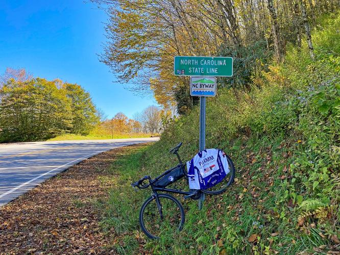
The finish is at Beech Gap and the Tennessee/North Carolina border.
When we were here in October 2020 there was no Tennessee border sign.
Roadway Surface and Traffic Report: The roadway surface is excellent. There is generally no shoulder and moderate traffic on this roadway but it feels like a safe ride.


