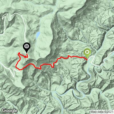
Snowshoe Drive East  Bike Climb - PJAMM Cycling

4.4
FIETS
8.3 mi
DISTANCE
2,585 ft
GAINED
5.4 %
AVG. GRADE

FULL CLIMB STATS

Page Contributor(s): John Summerson, The Complete Guide to Climbing (by Bike), 2nd Edition.

INTRO

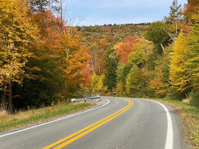
"The east side approach to the Snowshoe Ski area is a Jekyll and Hyde climb.  The first few miles along Route 66 are over solid grade and a narrow road but little traffic.  Through a tunnel of trees for the most part, at mile 4.4 the grade flattens and descends a short distance...After a short continuation of shallow/flat riding the grade rears up to a double digit and you must negotiate one of the steepest miles in the region through a few stacked switchbacks to get to its unmarked top at the growing Snowshoe Resort.  There are excellent views of the surrounding mountains within this section.  This is a challenging climb to high altitude (for the eastern United States).” (This quote is provided with approval of John Summerson from his book, The Complete Guide to Climbing (by Bike), 2nd Edition, pg. 101.)

See more details and tools regarding this climb's grade via our interactive Profile Tool.
Information Not Available

If you have any information regarding this climb, we'd like to hear from you. Click the CONTRIBUTE button to share your thoughts with us.

Information Not Available

If you have any information regarding this climb, we'd like to hear from you. Click the CONTRIBUTE button to share your thoughts with us.

Before heading out on any cycling adventure check out our Things to Bring on a Cycling Trip and use our interactive check list to ensure you don't forget anything.
Information Not Available

If you have any information regarding this climb, we'd like to hear from you. Click the CONTRIBUTE button to share your thoughts with us.

ROUTE MAP

MEMBER RATING

Not Yet Rated
-
Road
-
Traffic
-
Scenery

CURRENT WEATHER

PJAMM TRIPS ADVENTURE STARTER BUNDLES

Check out PJAMM Adventure's prepackaged (self-guided) cycling trips. They will help you plan, document and conquer your next adventure.
ALL TRIPS
Browse all of our prepackaged trips and find your next adventure!
Smoky Mountain National Park
United States (NC,TN)
17 ROUTES
31 POIs
ROUTE STATS (TOTAL)
181.8
mi
DISTANCE
34,253
ft
ELEV. GAIN
The Blue Ridge Parkway (North)
United States (NC,TN,VA)
38 ROUTES
70 POIs
ROUTE STATS (TOTAL)
716.5
mi
DISTANCE
75,697
ft
ELEV. GAIN
The Blue Ridge Parkway (South)
United States (NC,TN,VA)
30 ROUTES
63 POIs
ROUTE STATS (TOTAL)
690.7
mi
DISTANCE
74,180
ft
ELEV. GAIN

NEARBY CLIMBS (0) RADIAL PROXIMITY

FROM
No Climbs Found

MEMBER REVIEWS & COMMENTS

Let us know what you thought of this climb. Signup for our FREE membership to write a review or post a comment.
Already have an account?
ROUTE MAP
PROFILE TOOL
Route Data
S.G. (%)
hide
Segment Data
hide

Climb Profile Not Found
CLIMB SUMMARY

Cycling Snow Shoe Drive East, West Virginia - cyclist riding on two-lane roadway surrounded by dense fall foliage, small daisies on roadside

Cycling Snowshoe Drive East, West Virginia

Ride 8.3 miles gaining 2,563’ at 5.3% average grade.

This is an incredibly fun and scenic bike climb.  We start our climb in the Cass Historic District, which is listed on the National Register of Historic Places, and rightly so.  The climb is along a light to moderately travelled highway surrounded by forest that is exceptionally beautiful during fall colors.  The finish is at Snowshoe Resort, a ski mountain.

Cycling Snow Shoe Drive East, West Virginia - photo collage, railroad crossing, two-lane roadway surrounded by dense fall foliage, road sign for 11% grade, PJAMM Cycling logo in corner

This is the third hardest bike climb in West Virginia.  The last 1½  miles before a flat run to the finish averages 10.4%.  Do not let the fairly tame 5.3% average grade fool you.  There is a -1.9% two mile descent beginning at mile 4.3 that knocks down what would be a much higher average grade.  The 4.3 miles before the descent averages 7% and as noted the 1½ miles to just short of the finish average 10.4%.  This is a tough climb and is justifiably #3 in the state.

Cycling Snow Shoe Drive East, West Virginia - PJAMM adventure app shows climb grade and profile

PJAMM Adventure App and stats at climb start.

“The east side approach to the Snowshoe Ski area is a Jekyll and Hyde climb.  The first few miles along Route 66 are over solid grade and a narrow road but little traffic.  Through a tunnel of trees for the most part, at mile 4.4 the grade flattens and descends a short distance.  At mile 5.8 turn right toward the Snowshoe Resort to continue.  After a short continuation of shallow/flat riding the grade rears up to a double digit and you must negotiate one of the steepest miles in the region through a few stacked switchbacks to get to its unmarked top at the growing Snowshoe Resort.  There are excellent views of the surrounding mountains within this section.  This is a challenging climb to high altitude (for the eastern United States).” (This quote is provided with approval of John Summerson from his book, The Complete Guide to Climbing (by Bike), 2nd Edition, pg. 101.)

Cycling Snow Shoe Drive East, West Virginia - photo collage, train depot, Cass Scenic Railroad State Park, PJAMM Cycling logo in corner

The climb begins just after the train depot at Cass Scenic Railroad State Park.

From the state park website:

“Take a trip back to an era when steam-driven locomotives were an essential part of everyday life. Trips to Cass Scenic Railroad State Park are filled with rich history, unparalleled views and the sights and sounds of an original lumbering town. The park’s 11-mile long heritage railroad and authentic company town are some of the state’s most popular tourist attractions” (read more here).

Cycling Snow Shoe Drive East, West Virginia  - Cass Historic Railroad Depot, gift shop and restaurant

The gift shop and restaurant adjacent to the train depot are a fun place to visit.

And . . . load up for the climb ahead. 😋

Cycling Snow Shoe Drive East, West Virginia - town of Cass, historic informational signs with town history, wooden sidewalks, PJAMM Cycling logo in corner

Cass is just before climb start.

This was a company town founded in 1901 for the Est Virginia Pulp and Paper Company.

Cycling Snow Shoe Drive East, West Virginia - dense fall foliage along first third of climb

First third of the climb.

Cycling Snow Shoe Drive East, West Virginia - dense fall foliage along middle third of climb

Middle third of the climb.

Cycling Snow Shoe Drive East, West Virginia - dense fall foliage along final third of climb

Final third of the climb.

Cycling Snow Shoe Drive East, West Virginia - aerial drone footage shows dense foliage along both sides of two-lane raodway, PJAMM Cycling logo in corner

Drone video towards the end of the climb.

Cycling Snow Shoe Drive East, West Virginia - aerial drone footage shows dense fall foliage around many sharp turns in road along final segment of climb

Last few bends before the finish.

Cycling Snow Shoe Drive East, West Virginia - PJAMM Adventure App shows climb grade and profile

PJAMM Adventure App near climb finish.

Cycling Snow Shoe Drive East, West Virginia - bike parked in tall grass and along road at Snowshoe Ski Resort

Snowshoe Ski Resort is just down the road from the finish.

That’s a wrap!