Fleet Moss (SW #50) Bike Climb - PJAMM Cycling

1.9
FIETS
3.3 mi
DISTANCE
1,061 ft
GAINED
6 %
AVG. GRADE

FULL CLIMB STATS

INTRO

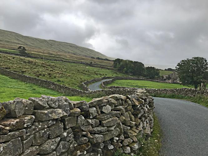
This is the highest climb in Yorkshire with some extremely steep pitches (14.5% for the steepest half km). This climb is #50 of Simon Warren’s Greatest 100 Climbs in Britain.  Other than a handful of farm buildings, there is nothing but sweeping views of rolling hills after the 400 meter mark of this 5.4 kilometer climb. Come prepared for a good bit of wind on this wide open stretch of roadway through the northern portion of Yorkshire Dales National Park.

Visit our Top UK Epic Climbs (The Burway #9) and also our Top England hill climbs pages (The Burway #4) for photos, summaries and statistics for their respective top epic hill climbs.  The lists on these pages were provided by one of the most knowledgeable hill climbers in Britain, Simon Warren
5.9% average grade (6.5% climb only).  The bulk of this climb is at 0-10%.  44% of the climb is at 0-5% and 32% is at 5-10%.  The steepest 500 meters is 14.5% and steepest kilometer is 12.1%.

See more details and tools regarding this climb's grade via the “Profile Tool” button.
Roadway:  Narrow two lane roadway in good shape with stone wall borders on much of the route. 

Traffic;  Light.

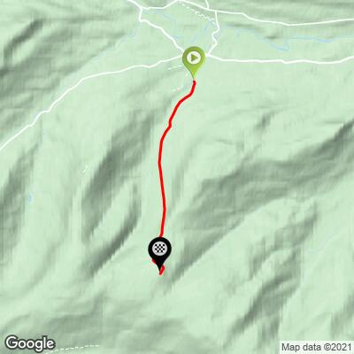
Parking:  Public parking 700 meters north from the start of the climb (MapStreet View). 
Provisions:  None along the climb.  There are places to get food and beverages in Hawes, where the climb begins.
Before heading out on any cycling adventure check out our Things to Bring on a Cycling Trip and use our interactive check list to ensure you don't forget anything.
This is #50 on the 100 Greatest Cycling Climbs, Britain and is one of 19 climbs in the Yorkshire section. Use the “Routes in Area” button on the menu bar above to see other bike climbs in the region.  

ROUTE MAP

MEMBER RATING

Not Yet Rated
-
Road
-
Traffic
-
Scenery

CURRENT WEATHER

PJAMM TRIPS ADVENTURE STARTER BUNDLES

Check out PJAMM Adventure's prepackaged (self-guided) cycling trips. They will help you plan, document and conquer your next adventure.
ALL TRIPS
Browse all of our prepackaged trips and find your next adventure!

NEARBY CLIMBS (0) RADIAL PROXIMITY

FROM
No Climbs Found

MEMBER REVIEWS & COMMENTS

Let us know what you thought of this climb. Signup for our FREE membership to write a review or post a comment.
Already have an account?
ROUTE MAP
PROFILE TOOL
Route Data
S.G. (%)
hide
Segment Data
hide

Climb Profile Not Found
CLIMB SUMMARY

moody clouds cover one-lane country road surrounded by pastureland and low stone fences

Cycling Fleet Moss, England

Ride 3.3 miles gaining 1,061’ at 6% average grade (¼ mile at 15.5%).


Fleet Moss is the highest road in Yorkshire and #50 on Simon Warren’s Greatest 100 Climbs in Britain list (from the north side). The climb is named after an area of moorland to the right just after cresting the hill coming from the north. In the Top 10 Most Epic Bike Climbs in England list Simon gave us before our second trip to the UK to document climbs, he lists Fleet Moss as #5.

photo collage shows bike parked next to sign for 20% grade; old brick buildings and stone fences, sheep grazing in pastureland

Of the climbs we have done thus far in England (50+ top bike climbs in 2018 and 2022), Fleet Moss is a strong contender for the top spot. She brings everything you could want in a climb. We’ll start this one with the ancient town of Hawes (it really is ancient - producing cheese for over 1,000 years). They even have a popular Creamery and Museum near the start point of the climb. A tough kick of double digit gradients takes you out of the town and past a few last old stone buildings. After the scattered stone buildings it will be just you and the cows on the steep slope as the road follows the canyon up to the summit. Hawes is in view for most of the climb and old stone fences parallel the road for the duration. Fleet Moss is a must do in the Yorkshire area. Hope for good weather!

photo collage shows town of Hawes at climb start; old stone buildings, stone bridge crossing creek

Start of climb - 12% for 150 meters.

After climbing a double digit grade for the first 200 meters, the hill loses its bite for the next 1.2 miles, which average a mild 2.1% average grade followed by 10% for 1.2 miles, and then easing off again for the final half-mile at 4%.

photo collage shows bike parked next to sign for 17% grade; aerial drone view of straight segment of country roadway surrounded by pastureland and fenced in on both sides by low stone fence

After the first 150 yards, the next 1.2 miles average 2.1%.

photo collage shows long straight stretch of one-lane roadway fenced in on both sides by low stone retaining wall, surrounded by green pastures

Other than a handful of farm buildings, there is nothing but sweeping views of rolling hills after the 400 meter mark of this 5.4 kilometer climb.  Come prepared for a good bit of wind on this wide open stretch of roadway through the northern portion of Yorkshire Dales National Park.

The descent is exceptional - it is a roller coaster fairly straight road that’s exceptionally steep for a one-kilometer stretch about a kilometer down from the top.

bike parked next to sign for 20% grade next to stone fence

Last push to the top.

The climb begins at the southern edge of the hamlet of Gayle, North Yorkshire, England:

Gayle, originally a farming settlement, grew in the late 18th century due to employment in local quarries, coal-mining in Sleddale, and a water-driven cotton mill on Gayle Beck (Wikipedia - Gayle, North Yorkshire).

photo collage shows cows grazing in fields, Yorkshire cattle country

This climb takes you through Yorkshire cattle country.

RoadCyclingUK.com writes of this climb:

“Yorkshire’s highest road is also one of the white rose county’s most iconic climbs, despite the Tour de France missing out Fleet Moss when cycling’s greatest race was in town in 2014.

Where cycling’s elite wouldn’t go up, however, plenty of others have – and the long, exposed climb with an unrelenting average gradient of 8.4 percent is a staple of any cycling trip to the Dales.”  

photo collage shows stone fences

Dry stone walls border our climb.

They are said to be 5,000 dry stone walls in the Yorkshire Dales.

photo collage shows pastureland and stone walls

CyclingUphill.com writes:

Fleet moss from Hubberholme (from the south) is slightly easier than from the north side. The gradient isn’t too steep – 17% at its maximum. However, it is long and persistently hard and is preceded by a long drag from Hubberholme. From Hubberholme to the top of Fleet Moss is 12 km, with total elevation gain of 400 metres. (net gain 240m to 602 metres). Those 12 km are at an average of 3%, but with some downhill thrown into the mix.”

This climb is in the middle of Yorkshire Dales National Park, which attracts over eight million visitors every year.  The park is 50 miles (80 km) north-east of Manchester; Leeds and Bradford lie to the south, while Kendal is to the west, Darlington to the north-east and Harrogate to the south-east.”  Wikipedia - Yorkshire Dales National Park. 

Top things to do in Yorkshire Dales National Park.

Our segment is the steepest section of Fleet Moss south.  The full 12 km ride from Hubberholme is provided via this link to Strava.

That’s a wrap!