Cycling Bwlch y Groes, Wales
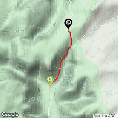
Ride 1.6 miles gaining 1,206’ at 14.1%
This extraordinary climb is in the northwestern section of Wales in the Snowdonia mountain region. This is the highest paved road and hardest bike climb in Wales. Bwlch y Groes means “Pass of the Cross.”
We completed this jewel in August 2018 and because it is so epic, came back for a second go in June 2022.

We asked Simon Warren to provide us with lists of both the Top 10 Hardest, and Top 10 Most Epic bike climbs in England, Wales, Scotland, and the UK. Simon ranked Bwlch y Groes as the fourth hardest climb in Wales (7 UK) and second most epic in Wales (after Stwlan Dam). We relied heavily on Simon Warren’s Top UK Climbs Series in ranking and documenting UK bike climbs (https://www.100climbs.co.uk/books) - they are the Gold Standard for cycling climbing in the UK.

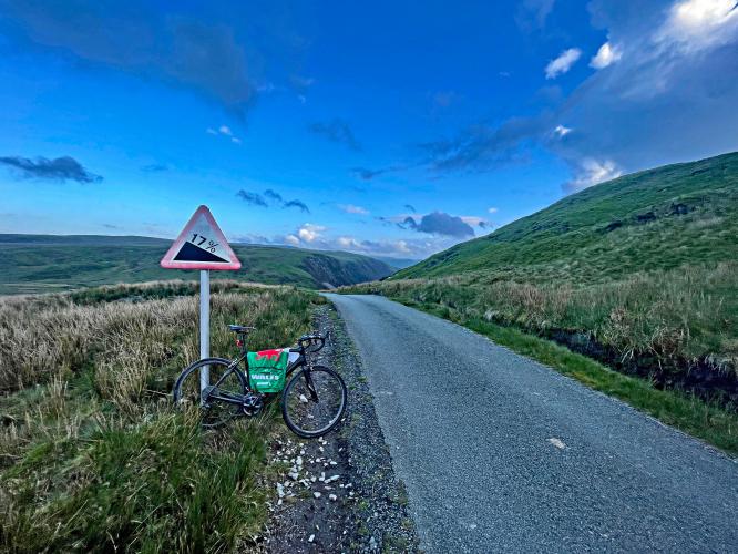
The climb begins as we pass a set of old farm buildings on the left.
The first 200-yard segment averages 15%, so be sure to warm up.
Wales has some gorgeous road bike climbs, and Bwlch y Groes is surely one of them! Wales treated us quite well on our visit in August 2018. We begin this climb in the midst of lush pastureland.

Climb summary by PJAMM’s Brad Butterfield who documented this climb in 2018 and again in 2022 (Wales is one of 27 countries Brad has cycled and documented for PJAMM in addition to 16 US states).
Each country has her crowned Jewel and Bwlch y Groes makes a good argument for taking that award for the Welsh territory. Far from any major towns, the starting point is near some very old homesteads. On my first climb up Bwlch y Groes in 2018 I got a flat tire on my vehicle that was parked in front of one of these homesteads and was assisted in fixing the flat by the old-timer that lived nearby. They are good people out here that enjoy a way of life much slower and unfamiliar to most others I think. Within a few hundred feet of the start point, a switchback of over 20% warns you of the battle to come. From there it's a steep and tough push to reach the saddle of the pass.

You’ll enjoy unobstructed views of the canyon as you pass Wale’s mascot - Sheep! And Lot’s of them. Okay - sheep is not the official mascot. In fact the Welsh flag has an imposing Dragon on it. But, I like to think it’s a Sheep in Dragon’s clothing.

View back down the dale at mile 0.75.
Soon into the ride we are climbing through a canyon area with dramatic plateaus and hillside formations, particularly on the right side as we climb. You’ll see the Foel Y Gordd formation as you enter the canyon area.

Views and scenery during the middle of the climb.

View in each direction at mile 1.25.

This is simply a magnificent cycling experience.

Stay left at the fork at mile 1.3.

This climb is along the southeastern edge of Snowdonia National Park (established 1951 - third national park in Britain after Peak District and Lake District).

Finish at the car park at the top of the climb.
This climb was renowned throughout the 1970s and 80s as the most challenging climb used in the Milk Race round-Britain cycle race (Wikipedia).
It also has a very interesting motorsport history:
“The History of Motor Sport and the Bwlch-y-Groes is nearly as old as motorsport. Early motoring magazines often mention that editorial staff hand car manufacturers had been testing on the Bwlch y Groes owing to its status of a continual and sever gradient to one of the highest moorland crossings by a road in the UK. This leaves us with a wealth of material describing the setting and condition of the road nearly a 100 years ago” (SpeedTrackTails).
Simon Warren writes of GCC #91:
“Named Hellfire Pass by the English but better known by its Welsh name, Bwlch-Y-Groes. . . is the highest tarmacked pass in Wales” (100 Greatest Cycling Climbs - Britain).
The road to get to this climb is brutally narrow with thick shrubs blocking the views ahead. Essentially every turn is a blind curve. On our climb, we encountered a car and had to back up nearly a kilometer to find a place where they could pass. The climb is really unique. The landscape is rough, it’s easy to see how the area gets pounded with rain and freezing temps most of the year. Luckily for us the rain was holding on our expedition. The climb goes up a ridge to a small parking lot, where we saw two other cyclists.

This is a true one lane road.
We rank this monster as #2 most difficult in UK via the Fiet’s index.
Also known as Hellfire Pass, Bwich-Y-Groes is the highest paved road in Wales. It is in the Aran Mountains near the south east edge of Snowdonia (The Guardian - Britain’s top 10 toughest cycle climbs).
“Snowdonia (Welsh: Eryri) is a mountainous region in north west Wales and a national park of 823 square miles (2,130 km2) in area. It was the first to be designated of the three national parks in Wales, in 1951.
The English name for the area derives from Snowdon, which is the highest mountain in Wales at 3560 ft (1,085 m). In Welsh, the area is named Eryri. A commonly held belief is that the name is derived from eryr ("eagle"), and thus means 'the abode/land of eagles',but recent evidence is that it means quite simply Highlands, and is related to the Latin oriri (to rise) as leading Welsh scholar Sir Ifor Williams proved.
The term ‘Eryri’ first appeared in a manuscript in the 9th-century Historia Brittonum, in an account of the downfall of the semi-legendary 5th-century king Gwrtheyrn (Vortigern).
In the Middle Ages the title Prince of Wales and Lord of Snowdonia (Tywysog Cymru ac Arglwydd Eryri) was used by Llywelyn ap Gruffudd; his grandfather Llywelyn Fawr used the title Prince of north Wales and Lord of Snowdonia.
Before the boundaries of the national park were designated, "Snowdonia" was generally used to refer to a smaller area, namely the upland area of northern Gwynedd centred on the Snowdon massif, whereas the national park covers an area more than twice that size extending far to the south into Meirionnydd. This is apparent in books published prior to 1951, such as the classic travelogue Wild Wales by George Borrow (1862) and The Mountains of Snowdonia by H. Carr & G. Lister (1925). F. J. North, as editor of the book Snowdonia (1949), states "When the Committee delineated provisional boundaries, they included areas some distance beyond Snowdonia proper." The traditional Snowdonia thus includes the ranges of Snowdon and its satellites, the Glyderau, the Carneddau and the Moel Siabod group. It does not include the hills to the south of Maentwrog. As Eryri (see above), this area has a unique place in Welsh history, tradition and culture.
Snowdonia National Park (Welsh: Parc Cenedlaethol Eryri) was established in 1951 as the third national park in Britain, following the Peak District and the Lake District. It covers 827 square miles (2,140 km2), and has 37 miles (60 km) of coastline.
The park is governed by the Snowdonia National Park Authority, which is made up of local government and Welsh representatives, and its main offices are at Penrhyndeudraeth. Unlike national parks in other countries, Snowdonia (and other such parks in Britain) are made up of both public and private lands under central planning authority. The makeup of land ownership at Snowdonia is as follows” (Wikipedia - Snowdonia National Park).

![]()
That’s a wrap!