![Cycling Rundlestone, England Cycling Rundlestone, England - road bike leaned against low rock wall next to hanging sign for Mount Tagvy Cottage along narrow two-lane road bordered by tall green hedges, Simon Warren's Greatest Cycling Climbs #11 logo in corner]()
Cycling Rundletsone, Tavistock, Devonshire, England.
Start of the climb.
![Cycling Rundlestone, England Cycling Rundlestone, England - photo collage, white sign for Tavistock Wrold Heritage Site Market & Stannary Town under dense tree foliage along roadside, aerial vies of pastureland, headstone looking old rock that says "Dartmoor National Park", PJAMM cycling logo in corner]()
This climb begins at the northeastern edge of Tavistock (ancient stannary and market town; pop. 11,018, 2011). Long, but not particularly challenging, the climb enters Dartmoor National Park at 900 meters and passes a very cool abandoned quarry two kilometers from the top. There are three challenging segments to this climb: (a) Start - 300 meters @ 10%, (b) km 2.5 to 3.9 @ 9.4% and (c) 800 meters beginning at km 6.1 that averages 9.2%). Otherwise, the climb is 7% or less with three brief descents along the way.
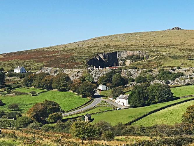
![Cycling Rundlestone, England Cycling Rundlestone, England - aerial views of abandoned granite quarry, a large hole in ground surrounded by pastureland and white buildings along the roadside, PJAMM Cycling logo in corner]()
View of Merivale and abandoned granite quarry -- km 6.5.
The climb is on B3357 but is named for the area of Rundlestone at the top of the climb.
![Cycling Rundlestone, England Cycling Rundlestone, England - low stone monument which looks like a headstone but actually is a sign for Dartmoor National Park, lots of fallen leafs along ground, next to tall green hedges]()
Enter park at 900 meters.
![Cycling Rundlestone, England Cycling Rundlestone, England - stone sign with regal horse silouette which says "Dartmoor National Park" along roadway in grass]()
![Cycling Rundlestone, England Cycling Rundlestone, England - photo collage, plaque with image of village commemorating the 70th anniversary of the institute, road bike parked next to plaque overlooking hillside, PJAMM Cycling logo in corner]()
Pork Hill Car Park and Viewpoint -- km 4.
![Cycling Rundlestone, England Cycling Rundlestone, England - low stone wall with road bike parked against it next to two-lane roadway with old stone building on far side of wall, iconic British red telephone booth along roadway next to pastureland, sunny, blue sky above, PJAMM Cycling logo in corner]()
Finish of the climb.
![]()
Steepest ½ kilometer begins at km 2.2 (11.5%).
![Cycling Rundlestone, England Cycling Rundlestone, England - sheep and white horses grazing in pastureland, PJAMM Cycling logo in corner]()
Pastureland along the route.
![Cycling Rundlestone, England Cycling Rundlestone, England - road sign stating "Dartmoor 40 mph zone" and "Animals on road take moor care"]()
Cycling Uphill says of the Rundlestone climb:
“Rundlestone is another long Devonshire climb in the heart of Dartmoor. Starting from the town of Tavistock, the climb goes East through the village of Merrivale towards Princetown and the top of Barn Hill. Rundelstone climb
Rundlestone is another long Devonshire climb in the heart of Dartmoor. Starting from the town of Tavistock, the climb goes East through the village of Merrivale towards Princetown and the top of Barn Hill.
It is a long undulating climb, with the hardest point coming mid-way as you go up ‘Pork Hill’. It is never really severe, averaging 8-10%. The next mile is actually downhill, so will come as welcome relief as you go into the tiny village of Merrivale. Merrivale is most famous for a series of nearby Bronze Age stones. After you cross the small river Walkham beyond Merrivale, there is the last part of the climb – another couple of miles of variable gradient.”
![Cycling Rundlestone, England Cycling Rundlestone, England - small old stone monument of some sort along roadway nestled in grass]()
This Southwestern England climb in Devon County is within the Dartmoor National Park (95,312 hectares / 235,520 acres) established in 1951 as a National Park of England:
“Dartmoor is an area of moorland in southern Devon, England. Protected by National Park status as Dartmoor National Park, it covers 954 km2 (368 sq mi).
The granite which forms the uplands dates from the Carboniferous Period of geological history. The moorland is capped with many exposed granite hilltops known as tors, providing habitats for Dartmoor wildlife. The highest point is High Willhays, 621 m (2,037 ft) above sea level. The entire area is rich in antiquities and archaeology.
Dartmoor is managed by the Dartmoor National Park Authority, whose 22 members are drawn from Devon County Council, local district councils and Government.
Parts of Dartmoor have been used as military firing ranges for over 200 years. The public is granted extensive land access rights on Dartmoor (including restricted access to the firing ranges) and it is a popular tourist destination” (Dartmoor National Park).


