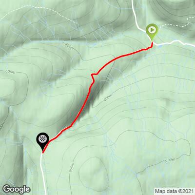
Cycling Buttertubs Pass, Scotland
Ride 2.4 miles gaining 841’ at 5.9% average grade (10.1% climb only).

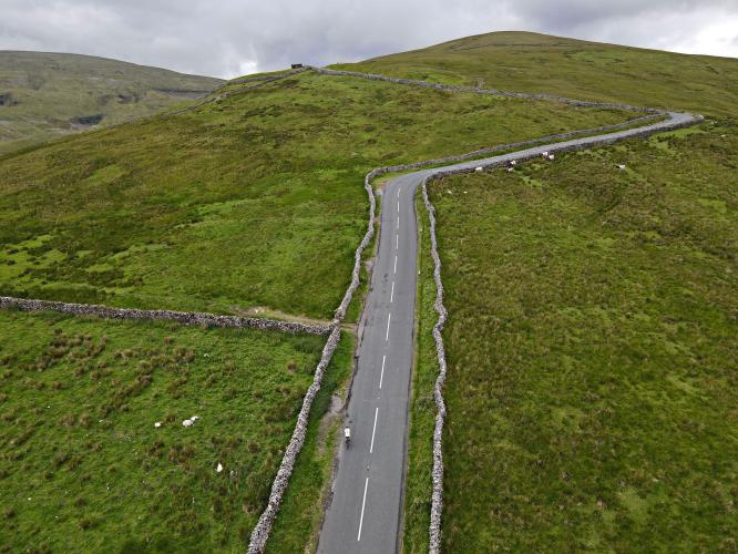
Buttertubs Pass in the exclamation mark at the end of the sentence: Hawes, Yorkshire is one of the most scenic and best riding locations in all of the UK(!). Having ridden Fleet Moss the day prior, I woke early to summit Buttertubs Pass the following day in the morning sun, before the afternoon noon rains came in. Buttertubs is located on the opposing mountain from Fleet Moss and also overlooks the historic town of Hawes. You’ll begin the route at an intersection with farms on both your left and right side. As you climb up, you get views of the vast farmlands that this historic land holds. Cheese and butter production has been the lifeblood of this area for centuries and the cows are sure to moo as you ride past them on their land. Two switchbacks about two-thirds of the way up the climb bring on the steepest grades of the Buttertubs Pass, as well as the best views. Past the switchbacks, the road levels out some as it cuts across the canyon to the saddle of the pass. When I rode in late June 2022, rain clouds came but didn’t stay for long. The periods that the sun did shine through were spectacular and unforgettable.

Start the climb at the T-intersection of Cliff Gate Road and B6270 near Thwaite.

This climb is in the northern section of Yorkshire Dales National Park, 217,800 hectares (538,195 acres), established in 1954:
“The Yorkshire Dales National Park is a 2,178 km2 (841 sq mi) national park in England covering most of the Yorkshire Dales. The majority of the park is in North Yorkshire, with a sizeable area in Cumbria and a small part in Lancashire. The park was designated in 1954, and was extended in 2016. Over 20,000 residents live and work in the park, which attracts over eight million visitors every year. The park is 50 miles (80 km) north-east of Manchester; Leeds and Bradford lie to the south, while Kendal is to the west, Darlington to the north-east and Harrogate to the south-east. The national park does not include all of the Yorkshire Dales. Parts of the dales to the south and east of the national park are located in the Nidderdale Area of Outstanding Natural Beauty” (Wikipedia - Yorkshire Dales National Park).

You’ll pass through the inevitable Yorkshire pasturelands as you climb this brute.

500 yards at 14% from 0.8 to 1.1 miles.

Beginning of steepest quarter-mile at 9/10ths mile.

Top of the steepest section.

Millennium Cairn and memorial bench 1.1 miles from start.

Buttertubs was included in the 2014 Tour de France:
![]()
Jens Voigt led over Buttertubs Pass in the 2014 TdF
Photo - Dean Atkins/SWpix.com and Yorkshire Post.
“5 July 2014 — Leeds to Harrogate, 190.5 km (118 mi)
The first stage began on The Headrow, outside the Victorian Town Hall in Leeds. The tour headed eastwards through the city centre towards Quarry Hill, navigating the Sheepscar Interchange onto the A61 and heading northwards through the city districts of Scott Hall, Moortown and Alwoodley towards Harewood House where a ceremonial start took place. This was attended by the Duke and Duchess of Cambridge, and Prince Harry. Following the departure from Harewood, the tour went along the Wharfe Valley passing through Otley, Burley in Wharfedale and the home of the Cow and Calf Rocks, Ilkley Moor. The race then headed north via the A65 to the market town of Skipton, before passing into the Yorkshire Dales National Park. After passing northwards through part of Wharfedale, into Wensleydale and through Hawes, the route continued over the Buttertubs Pass and down through Swaledale to Reeth. The race then headed south-east to cross the last categorised climb of the day at Grinton Moor before passing through Leyburn, the brewery town of Masham and the cathedral city of Ripon. Finally, travelling southwards, on the A61, through Killinghall and finishing at West Park in Harrogate.
A 50 km (31 mi) break saw Jens Voigt secure the King of the Mountains jersey for the day, before returning to the peloton. The finale of the stage saw Mark Cavendish crash during the sprint, following a collision with Simon Gerrans. Cavendish suffered a separated right shoulder injury, and had to retire from the tour after completing the stage. The sprint was won by Marcel Kittel, thus repeating his opening stage victory from the previous year.
Prizegiving was attended to by the Duke and Duchess of Cambridge, and Prince Harry, following a helicopter flight from their earlier engagement at Harewood House. Bernard Hinault was also in attendance, in his official capacity as a Tour de France representative, on the podium.” [Emphasis added] (Wikipedia - Stage 1 2014 TdF).

Finish at the unmarked peak of the climb at the cattle guard.
![]()
That’s a wrap!