![]()
Carlton Bank hosted the British National Hill Climb Championships in 1996 (Stuart Dangerfield wins the second of his 3 consecutive championships this year).
![]()
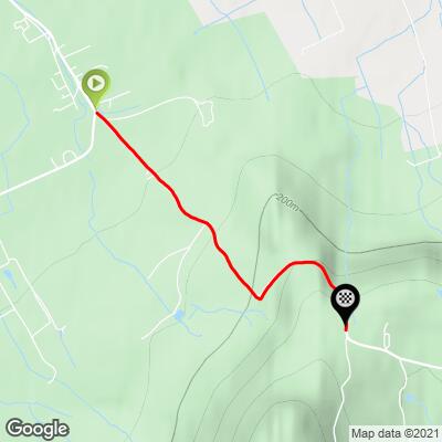
This climb begins modestly at 3.5% for the first 250 meters, then gradually increases to a very difficult 17 ½ % grade for 200 meters beginning at kilometer 1.5.
![]()
Looking back from just past the 17.5% 200 meters.
The climb begins at the southeastern edge of Carlton-in-Cleveland, a small village of about 300 in North Yorkshire that dates back to the 11th century.
![]()
Climb begins just outside of Carlton.
![]()
There are wonderful views along the climb but
it was overcast and dreary the day of our visit.
![]()
Steepest ½ kilometer begins at 1.3 km (14.5%)
CyclingUphill.com:
“Carlton Bank is located in the Cleveland hills, north east England. It is on the north west edge of the North York Moors. From the top of Carlton Bank you get great views over the surrounding countryside.
It is used as a venue for a hill climb by Cleveland Wheelers and also the National hill climb championship in 1996.
https://cyclinguphill.com/carlton-bank/
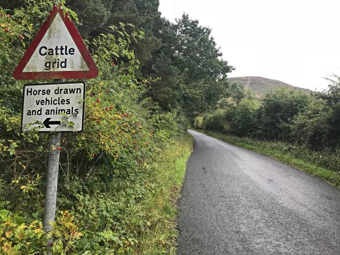
Once out of Teesdale and passed the cattle guard it is very steep, up to 25% in some places. There is a sheer drop down one side – and is popular area for hang-gliders.
#58 of on Simon Warren’s 100 Greatest Cycling Climbs (Britain) with sweeping views and Lord Stones Country Park Restaurant at the top. The restaurant is highly rated and there is a footpath with great views from the Cleveland Way National Trail - Lord Stones to Clay Bank.
Cleveland Way National Trail:
“The Cleveland Way is a National Trail in ancient Cleveland in northern England. It runs 110 miles (177 km) between Helmsley and the Brigg at Filey, skirting the North York Moors National Park.
History
Development of the Cleveland Way began in the 1930s when the Teesside Ramblers' Association pressed for the creation of a long distance path in the north-east of Yorkshire linking the Hambleton Drove Road, the Cleveland escarpment and footpaths on the Yorkshire coast. Subsequently, in 1953, a formal proposal to create the route was submitted to the North Riding of Yorkshire Council by the National Parks Commission. The trail was officially opened in 1969. It was the second official National Trail to be opened.
Route
The trail can be walked in either direction linking the trailheads of Helmsley (grid reference SE6125183849) and Filey (grid reference TA1155480742) in a horseshoe configuration. The trail is waymarked along its length using the standard National Trail acorn symbol.
The trail falls into two roughly equal sections. The inland section leads west from Helmsley, then north, then east around the west of the North York Moors National Park. It then leaves the National Park near Guisborough to meet the coast at Saltburn. It re-enters the National Park just north of Staithes; the coastal section follows the coast from Saltburn to Whitby, then leaves the National Park for the final time at Cloughton Wyke to reach Scarborough and Filey.” Wikipedia - Cleveland Way
The climb begins at the northwestern edge of Carlton-in-Cleveland:
“ Carlton in Cleveland is a village in the Hambleton district of North Yorkshire, England, and on the edge of the North York Moors National Park. It is situated approximately 9 miles (14 km) south of Middlesbrough. The village is commonly known as Carlton, and is the only village in the civil parish of Carlton.
The population of the parish was estimated at 300 in 2013.
Carlton in Cleveland has a school, Carlton and Faceby Primary School, and a public house, the Blackwell Ox, but no longer has a post office or shop. Carlton Outdoor Education Centre within the village provides activities for children.
History
Carlton was first mentioned in the Domesday Book in 1086. By the 14th century it had become known as Karleton in Clyveland (Carlton in Cleveland), to distinguish the place from other places named Carlton. "Cleveland" refers to the historic region of Cleveland. The village did not form part of the county of Cleveland during its brief existence from 1974 to 1996.
In the Middle Ages it appears that Carlton was a chapelry in the parish of Rudby, but by 1611 Carlton had its own church, and was considered a separate parish. The present church, dedicated to St Botolph, was completed in 1897. It was designed by Temple Moore, and is a Grade II listed building.”
The Carlton Bank climb is in the northwestern edge of North York Moors National Park, established 1952 with 143,000 hectare (353,361 acres):
“The North York Moors is a national park in North Yorkshire, England, containing one of the largest expanses of heather moorland in the United Kingdom. It covers an area of 554 sq mi (1,430 km2), and has a population of 23,380. The North York Moors became a National Park in 1952, through the National Parks and Access to the Countryside Act 1949.
To the east the area is clearly defined by the impressive cliffs of the North Sea coast. The northern and western boundaries are defined by the steep scarp slopes of the Cleveland Hills edging the Tees lowlands and the Hambleton Hills above the Vale of Mowbray. To the south lies the broken line of the Tabular Hills and the Vale of Pickering.
Four roads cross the moors from north to south. In the east the A171 joins Whitby and Scarborough. Further inland, the A169 runs between Pickering and Whitby. More centrally, a minor road departs from the A170 at Keldholme and passes through Castleton before joining the A171 which connects Whitby and Guisborough. The most westerly route is the B1257 connecting Helmsley to Stokesley. The A170 from Thirsk to Scarborough marks the southern boundary of the moors area.
The Esk Valley Line is an east-west branch line rail link from Whitby to Middlesbrough in the north and the North Yorkshire Moors steam railway runs from Pickering to Grosmont with a link to Whitby.” Wikipedia - North York Moors National Park