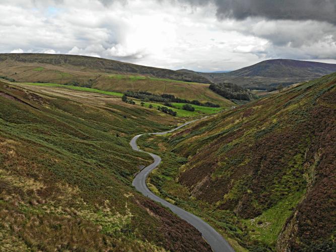
The multicolored “Trough” of Bowland.

This is a gorgeous 2.1 kilometer jewel that runs through Bowland Forest Area of Outstanding Natural Beauty.

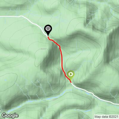
The climb is more beautiful than challenging, with an average grade of 6.3%, although there is a 180 meter stretch that will test the best of us at 19.3%!

Beginning of 19% 180 meter segment.
There are several memorials to cyclists at the finish.

Various cycling related memorial plaques at the finish.
This is simply a stunning climb and one of our Must-Do’s of the 100 Greatest Cycling Climbs, Britain.
![]()
Steepest ½ kilometer begins at 1.3 kilometers (16%)
Simon Warren writes of this climb, “this topographical masterpiece winds its way out of the Forest of Bowland. The Area of Outstanding Natural Beauty (AONB) is a stunning region to ride and its crowning glory is this climb” (100 Greatest Cycling Climbs, p. 130).
What is the “Trough of Bowland”?
“The Trough of Bowland is a valley and high pass in the Forest of Bowland Area of Outstanding Natural Beauty, Lancashire, England.
The pass, reaching 968 ft (295 m) above sea level at the head of the valley, links to Wyresdale, dividing the upland core of Bowland into two main blocks. Though steep and narrow, the road is the most direct connection between Lancaster and Dunsop Bridge, and hence Clitheroe. It was the route taken by the "Pendle witches" to their trial at Lancaster Castle in 1612. The Grey Stone of Trough, at the head of the pass, marks the line of the pre-1974 county boundary between Lancashire and the West Riding of Yorkshire. Historically, the Trough marked the westernmost boundary of the ancient Lordship of Bowland.
The Trough is scenic and popular with visitors, particularly walkers and cyclists, so it is unsurprising that it is sometimes considered synonymous with the Forest of Bowland as a whole. However, it is in fact only a small part of the wider Area of Outstanding Natural Beauty at 312 sq mi (810 km2).
- The Ordnance Survey indicates the Trough of Bowland to be solely the steep upper valley of Losterdale Brook above Trough Barn. However, the generally used definition includes:
- The main valleys of Langden Brook and its tributaries, as far as Dunsop Bridge,
on the Wyresdale side of the pass, the moorland and wooded valley of Trough Beck as far as Trough Bridge; most reasonably extend the western 'boundary' to encompass the rest of the wooded headwater valley of the Wyre as far as Marshaw” (Trough of Bowland).
RoadCyclingUK.com shares a nice summary of an 83 mile ride with 6,994’ of climbing through the Trough of Bowland:
“Sir Bradley Wiggins trained in the Forest of Bowland ahead of his 2012 Tour de France win. And with tough, steep climbs, stunning vistas and quiet roads, it is easy to see the attraction.
Where are Tour de France champions made? In the build-up to the 2012 race, Bradley Wiggins trained on the roads of the Forest of Bowland before becoming Great Britain’s first Tour de France winner. It’s easy to see why - the Forest of Bowland, nestled in the north of Lancashire, is prime cycling territory: tough climbs, incredibly lush countryside and quiet roads.
The Forest of Bowland Area of Outstanding Natural Beauty, more commonly referred to as the Trough of Bowland by locals and cyclists, is sandwiched between the Yorkshire Dales and the coast, with the M6 motorway marking the western boundary and doing a sterling job of keeping the heavy traffic out of the area. Being able to escape from the world and ride on unspoilt lanes is one of the primary draws of the Trough of Bowland - besides the stunning terrain.
Very few roads cross the Trough but that works in its favour as motor vehicles can’t use the forest as a shortcut, so you’re only likely to encounter locals out on the roads. It also means the best way to take in the area is to do a loop of the forest and our ride follows an 83-mile route with 6,994 feet of climbing, starting from the town of Clitheroe (you can see the full route and download a GPS file here). . .” (Full Article here).
Forest of Bowland Area of Natural Beauty:
“The Forest of Bowland, also known as the Bowland Fells, is an area of barren gritstone fells, deep valleys and peat moorland, mostly in north-east Lancashire, England with a small part in North Yorkshire (before 1974, some of the area was in the West Riding of Yorkshire). It is a western spur of the Pennines[1] and was once described as the "Switzerland of England".
The Forest of Bowland has been designated an Area of Outstanding Natural Beauty (AONB) since 1964. The Forest of Bowland AONB also includes a detached part known as the Forest of Pendle separated from the main part by the Ribble Valley, and anciently a forest with its own separate history. One of the best-known features of the area is Pendle Hill, which lies in Pendle Forest. There are more than 500 listed buildings and 18 scheduled monuments within the AONB.
Bowland survives as the north-western remainder of the ancient wilderness that once stretched over a huge part of England, encompassing the Forest of Bowland, Sherwood Forest (Nottinghamshire), the New Forest (Hampshire) and Savernake Forest (Wiltshire). While the Trough of Bowland (the valley and high pass connecting the Wyre (at Marshaw) and Langden Brook and dividing the upland core of Bowland into two main blocks) represents the area, to many, on account of its popularity, it is in fact only a small part of the wider Forest of Bowland area.
The hills on the western side of the Forest of Bowland attract walkers from Lancaster and the surrounding area. Overlooking Lancaster is Clougha Pike, the western-most hill. The hills form a large horseshoe shape with its open end facing west. Clockwise from Lancaster the hills are Clougha Pike (413 m or 1,355 ft), Grit Fell (468 m or 1,535 ft), Ward's Stone (561 m or 1,841 ft), Wolfhole Crag (527 m or 1,729 ft), White Hill (544 m or 1,785 ft), Whins Brow (476 m or 1,562 ft), Totridge (496 m or 1,627 ft), Parlick (432 m or 1,417 ft), Fair Snape Fell (510 m or 1,670 ft), Bleasdale Moor (429 m or 1,407 ft), and Hawthornthwaite Fell (478 m or 1,568 ft). Considerable areas of the Bowland fells were used for military training during the Second World War, and there are still unexploded bombs in some areas.
The area contains the geographic centre of Great Britain which is close to the Whitendale Hanging Stones, around four miles (6 km) north of Dunsop Bridge. The historical extent of Bowland Forest is divided into two large administrative townships, Great Bowland (Bowland Forest High and Bowland Forest Low) and Little Bowland (Bowland-with-Leagram), but the modern-day AONB covers a much larger area” (Forest of Bowland).
LakesCyclist.wordpress.com:
“There are many places which could lay claim to the accolade of best cycling terrain in Northern England.
The classic climbs of the Lake District with the ferociously difficult slopes of Hardknott, Wrynose and Honister passes would have many supporters. The Yorkshire Dales and the North Pennines each carry their distinctive challenges and share a wild beauty.
Unless you lived in the North West, you might be unaware of the quiet and often overlooked landscape of the Forest of Bowland. Somehow it tends to be bypassed in the rush to travel North to the Lake District, or East to the Yorkshire Dales. If you have never been there you might expect great expanses of trees but in fact they are notable by their comparative absence. ‘Forest’ in this context relates to hunting and shooting estates, and this gives something of a clue to the nature of the area. Instead of trees there are large areas of rolling hills and high peat moorland deeply cut in places by rivers. The roads rise and fall with the landscape and thus there is virtually no easy cycling to be had.
The main feeling is one of isolation and yet this is the nearest hill country to much of Northern Lancashire. This proximity has meant that the Bowland Fells have had a long tradition of attracting cyclists.
The Trough of Bowland has always been a favourite climb dating back to the heyday of club cycling in the 1930s.
In recent years many of the roads have featured in the ‘Tour of Britain’. . .
. . . Somehow there seem to be no flat roads in this area. Out of Slaidburn, the road climbs then drops and appears to be heading towards a dead-end, with steep hillsides barring further progress. At a right turn the way ahead becomes clear. A small river cuts deeply into the hills and the ‘Trough of Bowland’ road follows the stream towards a fold in the hills. At first the road rises high above the stream but soon the valley bottom rises and the road follows it until with a left turn, the v shaped top of the Trough is revealed . The road climbs steeply to a cattle grid and the climb is over.” (Link to Full Article here.)
ClimbingCyclist.com:
“The Trough of Bowland is a wonderful climb from Dunsop Bridge towards Lancaster. The 100 climbs version is 1.3 miles, average gradient of 6%; with the last section getting up to 15%. On a good day there are great views.”