
20.4
PDI
14.4 mi
DISTANCE
4,084 ft
GAINED
4.4 %
AVG. GRADE
FULL CLIMB STATS
INTRO
The western climb to Čakor Pass starts in Murino, in Montenegro's Plav Municipality, and runs 23.2 km (14.4 mi) to the pass on the Kosovo border. Our data shows 1,245 m (4,084 ft) of climbing at a 4.4% average grade, from about 834 m (2,737 ft) to 1,842 m (6,043 ft), with some rolling terrain that adds to the total. Čakor is not a steep pass: the grade is mostly 4 to 6%, with a steepest kilometer of 8.6% and a steepest 10 km (6.2 mi) of 5.5%.
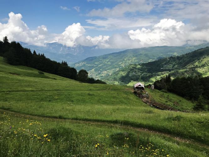
The road is wide, asphalt, and follows the terrain up through mountain pastures into an amphitheatre of peaks in the Prokletije range. You pass the church at Velika about 8 km (5 mi) up, and the final stretch brings two hairpins and a long straight to the summit. Traffic is very light and the road feels remote. At the pass, monuments commemorate the dead of both World Wars and the opening of the road by King Aleksandar of Yugoslavia in 1925, and the views run toward the Komovi range.
The summit sits on the Montenegro-Kosovo border, and this is not a regular open crossing: the road was closed during the Kosovo War in 1999 and reopened only in 2011, and on the Kosovo side it turns to rough, unpaved track. Plan to turn around at the top. Our Cakor Pass East page covers the approach from the Kosovo side.
PLAN YOUR ROUTE
 We've partnered with Sherpa-Map.com to bring you the best route planning tool. With a PRO Membership you can use this climb as a reference when creating your route.
 The climb covers 23.2 km (14.4 mi) and gains 1,245 m (4,084 ft) at a 4.4% average, from about 834 m (2,737 ft) in Murino to 1,842 m (6,043 ft) at the pass. The net height difference between start and finish is about 1,008 m (3,306 ft); the rest of the gain comes from rolling sections.
The steepest 10 km (6.2 mi) averages 5.5%, the steepest 5 km (3.1 mi) averages 6.1%, the steepest 2 km (1.2 mi) averages 7.3%, and the steepest single kilometer averages 8.6%. The steepest half kilometer (0.3 mi) runs at 13.1%.
Riders describe a steady 4 to 6% grade that is rarely steeper, which makes it a good pass for finding a rhythm. The effort is more about the distance and the altitude than about any single ramp.
Roadway: The Montenegrin side is asphalt and wide, widened to about 4 m (13 ft) up to the border in 2011. Riders have reported short sections damaged by landslides in the middle of the climb that reduced the road to a single lane. Snow and avalanches regularly close the pass in winter, so it is best ridden in summer.
Traffic: Very light. This is a remote border road with long, near-empty stretches, especially in the upper part of the climb.
Parking: Murino is a small village, so parking is informal. Plav, the municipal seat on Lake Plav, is the practical base for lodging and supplies and a short drive away.
A standard road bike is fine on the asphalt. Gearing with a comfortable low end is useful for 23 km (14 mi) of sustained climbing at altitude.
Services are sparse beyond Murino and Velika, so start with full bottles and food. Riders report a spring at the top beside the memorial. Carry your passport: the summit is a border zone, and riders have reported document checks near the pass. Weather can change quickly at 1,842 m (6,043 ft), so pack a jacket for the descent.
Before heading out on any cycling adventure check out our Things to Bring on a Cycling Trip and use our interactive check list to ensure you don't forget anything.
Plav is a lake town below the Prokletije mountains, and it is the natural base for this climb and for exploring nearby Gusinje and the Albanian border area. The descent from the pass returns through Murino, with Gusinje and the Albanian border further on.
From the summit, the road on the Kosovo side leads toward Peć (Peja) and the Rugova Gorge, but it is unpaved and the border is not a regular crossing, so do not plan to ride through. Check conditions at the pass before you set out with our Weather tool, since snow and avalanches close the pass in winter.
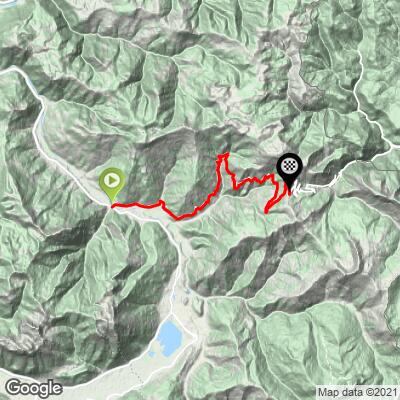
ROUTE MAP
MEMBER RATING
CURRENT WEATHER
PJAMM TRIPS ADVENTURE STARTER BUNDLES
Check out PJAMM Adventure's prepackaged (self-guided) cycling trips. They will help you plan, document and conquer your next adventure.
NEARBY CLIMBS (0) RADIAL PROXIMITY
FROM No Climbs Found
MEMBER REVIEWS & COMMENTS
Let us know what you thought of this climb. Signup for our FREE membership to write a review or post a comment.
Already have an account?
LOG IN HERE
