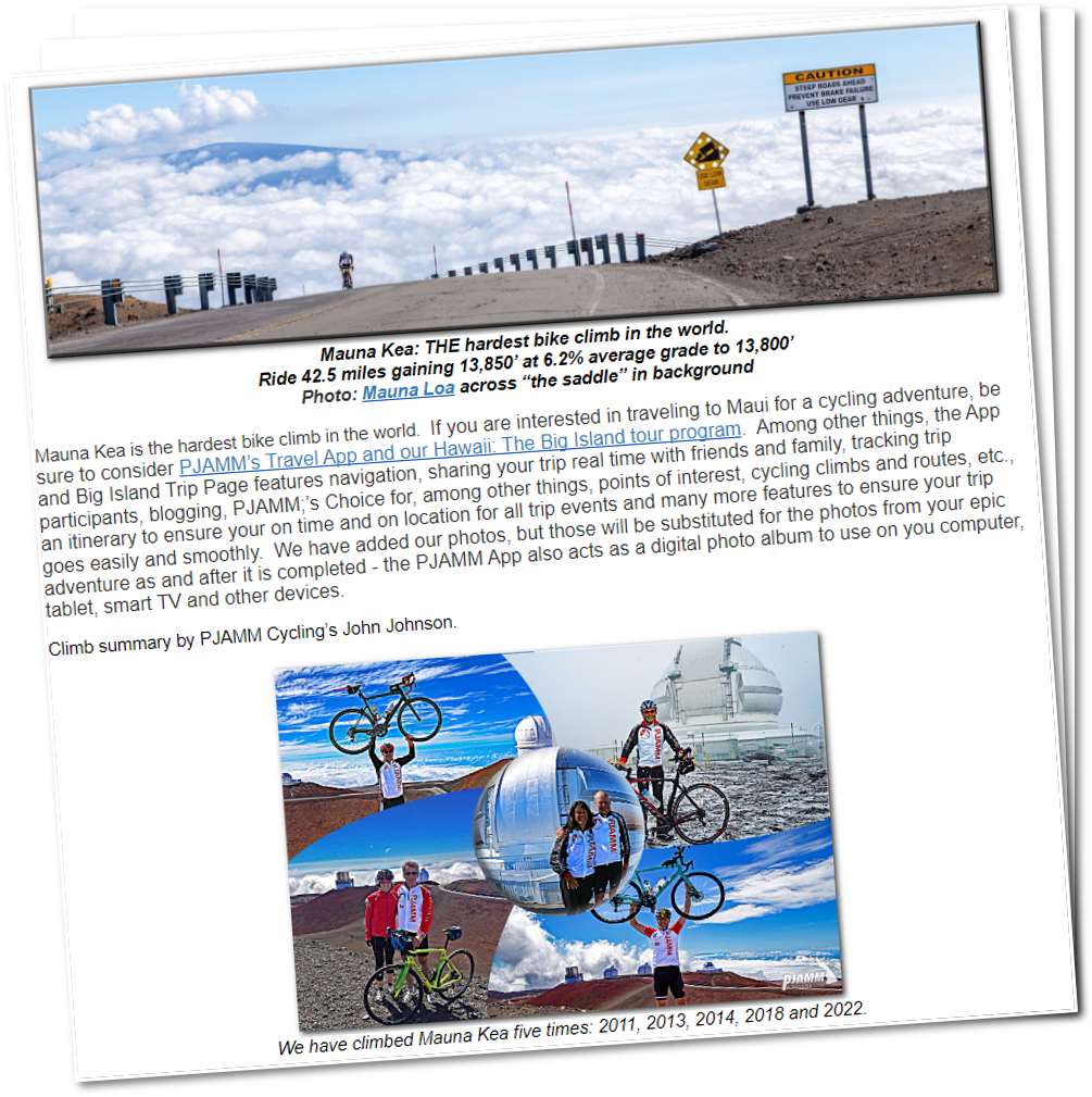
Mauna Kea: THE hardest bike climb in the world.
![]()
Ride 42.5 miles gaining 13,850’ at 6.2% average grade to 13,800’
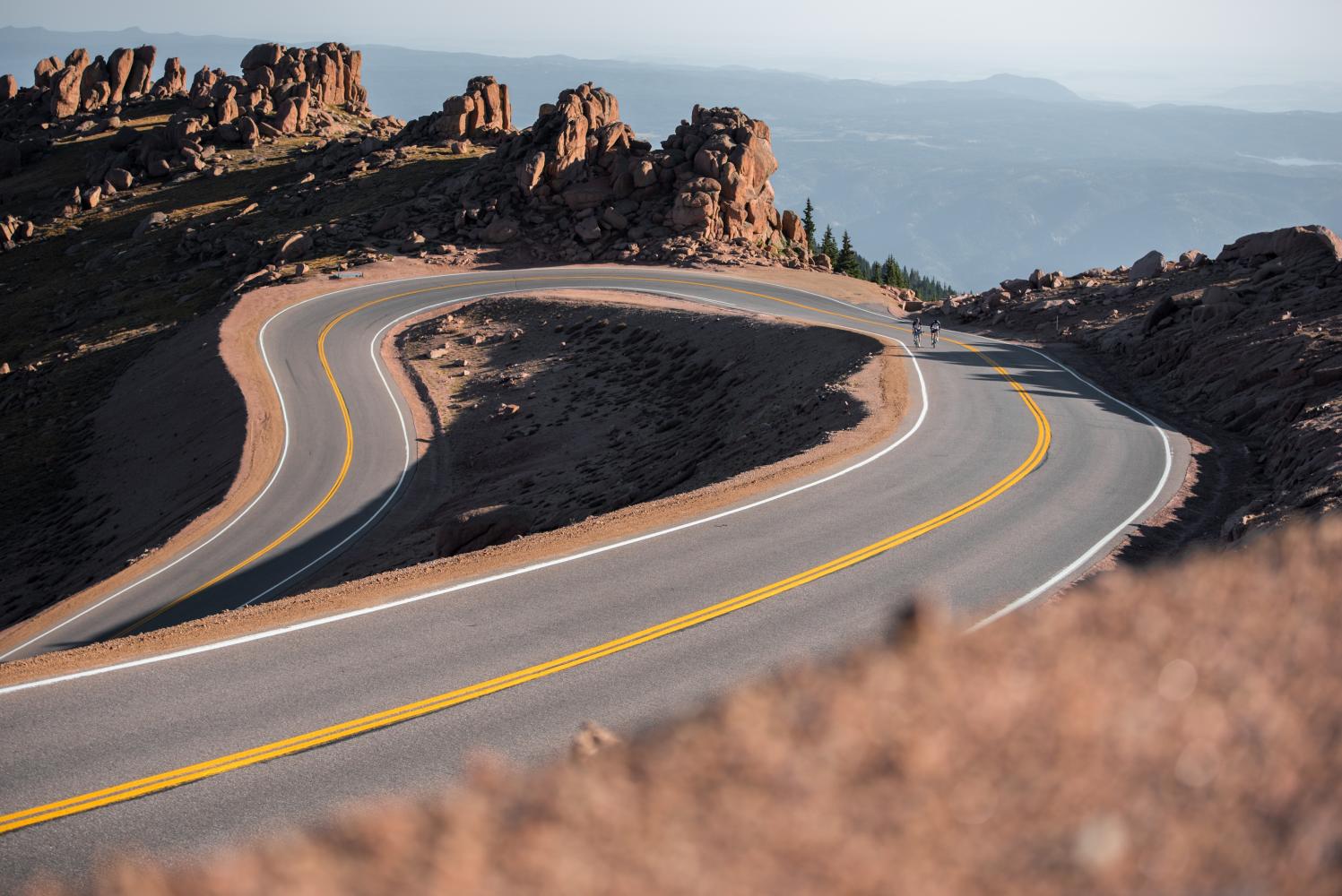
Photo: Mauna Loa across “the saddle” in background
Mauna Kea is the hardest bike climb in the world. If you are interested in traveling to Maui for a cycling adventure, be sure to consider PJAMM’s Travel App and our Hawaii: The Big Island tour program. Among other things, the App and Big Island Trip Page features navigation, sharing your trip real time with friends and family, tracking trip participants, blogging, PJAMM’s Choice for, among other things, points of interest, cycling climbs and routes, etc., an itinerary to ensure your on time and on location for all trip events and many more features to ensure your trip goes easily and smoothly. We have added our photos, but those will be substituted for the photos from your epic adventure as and after it is completed - the PJAMM App also acts as a digital photo album to use on your computer, tablet, smart TV and other devices.
SUMMARY BY JOHN JOHNSON
(PJAMM Cycling’s Founder & CEO)

We have climbed Mauna Kea five times: 2011, 2013, 2014, 2018 and 2022.
Mauna Kea is the most difficult bike climb in the world and one of the most epic. Adjectives do not do justice in describing this climb. Distinguished by the highest Fiets Index in the world, Mauna Kea is a monstrous, nearly impossible ascent. In addition to the daunting climb, cyclists must be mentally and physically prepared for changing weather conditions, altitude sickness, and varying terrain on this extremely challenging 42 mile climb.

Not much vegetation on a volcano.
GENERAL INFORMATION
Before heading to Hawaii for your Mauna Kea cycling adventure, be sure to rely on our list of Things to Bring on a Cycling Trip, and use our interactive checklist to ensure you don't forget anything.
What Makes This the World’s Hardest Road Bike Climb:
The sheer elevation ascended (13,800’/4200m), the average grade (9.9% for the last half of the ride), dealing with the gravel for 4.7 miles, the altitude (be prepared for the possibility of altitude sickness, as it commonly occurs above 8,000 feet; Wikipedia), and dramatically changing weather (for example, rain and 80 degree weather in Hilo, followed by wind, snow, and sub 40 degrees at the top, depending on the season). On one climb up the volcano in December, it was 73 degrees in Hilo when we started, and we endured as low as 34 degrees and blustery snow towards the summit.

Well . . . you can’t say they didn’t warn you . . . 😨
When to Climb Mauna Kea:
We have taken on Mauna Kea twice in May, twice in June, and once (foolishly) in December. We recommend going in May or June, as these are the lowest rainfall months for the start of the climb in Hilo. The highest rainfall months there are March, April, and November. The temperature throughout the year always averages in the 70s so it will be warm in Hilo when you start, but often cold to extremely cold (it was in the 30s and snowing in December 2013 when we rode to the top).

PJAMM’s Brad Butterfield on Mauna Kea summit, December 20, 2013.
Checking Road and Weather Conditions on Mauna Kea:
The best resource for Mauna Kea road conditions and status is the Mauna Kea Weather Center. For example, when I originally typed this entry on January 14, 2020 from my hotel in Kona, I had just checked the MKWC site and the road from the VC to the summit was closed due to snow and ice - good to know! Additionally, each PJAMM Cycling climb page has current and forecasted weather for the start and finish of each climb.
How to Climb Mauna Kea by Bike:
There are more tips below, but in a nutshell:
- Train, train, train. Be in the absolute best shape you can be before even thinking about this climb;
Choose the right time to do the climb, we suggest May-early June (better weather, cheaper prices); - The climb finishes at nearly 14,000’. To the extent possible, altitude train, either using an altitude tent or riding up Mauna Loa or to the Mauna Kea Visitor Center days before the full MK climb. Perhaps that’s just psychological because the studies indicate it takes at least three weeks to “fully acclimate” to altitude, but we recommend it anyway. Regardless of what studies say, we have always ridden Haleakala (Maui) and Mauna Loa on the same trip before riding Mauna Kea and that seemed to help us. One of our cyclists used an altitude tent in preparation and he felt that was an advantage;
- Be prepared to swap out to a mountain bike or at least change wheels/tires on your cross bike to 38-40mm (only for very strong riders) at the Visitor Center (mile 34) for the 4.6 miles of sand/gravel beginning at mile 34.2. The pavement begins again at about mile 39 and the last three miles are paved. We do recommend a mountain bike or a bike that can handle 2.25” size tires (that is 57mm as a comparison to the 40mm gravel tire mentioned above);

End of the gravel. May 2018.
40mm gravel tires on a Specialized Crux cross bike.
- Make absolutely certain you have warm clothes for the trip above the visitor center. The temperature will be between 25-40℉ (14-22℃) colder at the top than in Hilo at the start.
![]()
Photo: Riding up Mauna Loa - Mauna Kea is in the background.
- Have SAG support. If you do not have your own:
- Christian James (also an exceptional photographer) can be hired to SAG and photograph your momentous ride. Phone (440) 225-9807, email: ChristianJamesPhoto@gmail.com and website here.
- PJAMM founder John Johnson’s personal note and endorsement: Chris and Jen SAGed for us on our 2022 Mauna Kea climb and they were absolutely INVALUABLE, pleasant, fun, competent, enthusiastic and supportive. They have supported cyclists on the Mauna Kea climb many times and know exactly where to stop for support and for photographs. Many of Christian’s exceptional photographs appear on this page. If you are attempting the Mauna Kea climb I strongly and without any reservation recommend using Chris and Jen.

Chris, John, and Jen after our May 24, 2022 Mauna Kea climb.
- PJAMM’s Bruce Hamilton’s tips for an unsupported climb (not recommended): If you’re really riding it all solo with no equipment changes, I’d ride something like 38-42mm tires with knobbies on the sides and a slick stripe down the middle. Pump them to max pressure to start and then take them down to maybe 25 psi at the visitor center. If you are riding down, remember that it’s not just a screaming descent – adjust your time to account for going very slowly on the dirt even when coming down. It’s quite rough on an unsuspended bike and adds substantial time (and discomfort) to your descent.
What Gear to Bring to Climb Mauna Kea by Bike:
We have always done the paved portion of the climb with a compact disk and in 2011 (27t cassette at age 55), 2013 (30t age 57), 2014 (32t age 58), 2018 and 2022 (30t chainring and 42t cassette - age 61 & 65 - see a trend here . . . ). In 2018 and 2022 I used a specially fitted Roubaix Crux cross bike that I used 30mm tires for pavement and 38mm knobby tires for the gravel. Note that for all but exceptional riders, I recommend swapping to a mountain bike for the gravel - I am not an exceptional rider at age 65 and would have been much better served with a mountain rather than gravel bike in 2022. As noted above, bring very warm clothes for the top. You may also wish to bring breathable rain gear because there is a good chance of rain in Hilo, regardless of the month you pick to tackle the climb.
Micah Ling’s Input: Bike - Moots Routt RSL -- same bike all the way up. I started with about 55 psi, lowered to about 30 for the gravel, did not reinflate. Maxxis Rambler tubeless tires, size 38. I'd ride this setup again, just because I'm so used to it. The bike did me well even though I had to walk a couple sections. I might go up to 42 for the tires.
MAUNA KEA FROM A DISTANCE

As seen from Mauna Loa.

Mauna Kea as seen from Waikoloa Road (55 miles)
Other four photos are of Mauna Kea as seen from Mauna Loa.

Mauna Kea left, Mauna Loa right.
Top photo: From the air leaving Kona
Bottom Photo: From Waikoloa Road (55 miles)
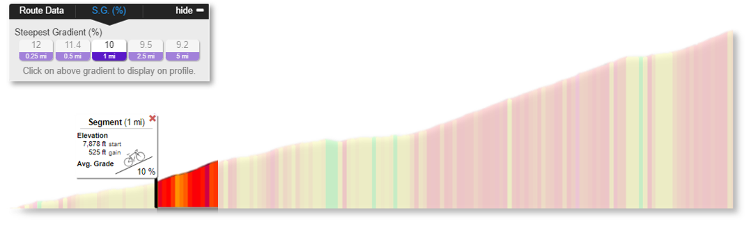
RIDE SEGMENTS
![]()
Statistics for the four segments of this climb.

PJAMM’s interactive profile tool (exit this summary to access profile tool)
The steepest segments are on the gravel and last paved section
Quarter-mile at 15.3%; 2.5 miles at 12.4%.
Where to Start:
The traditional start for Mauna Kea, and the location that ranks Mauna Kea as the highest rated bike climb in the world, is Hilo, Hawaii. It is best to stay in Hilo so you needn’t get up at an insane time to drive from the west side of the Island (Kona side) to the east side (Hilo). Twice we have made the early morning trek across the island to start the climb and do not recommend it. In 2022, we stayed in Waikoloa but also rented a hotel in Hilo the night before our climb so we could get up 1.5 hours later (still up at 4 a.m. for sunrise start).

Dipping our bike wheels in the Pacific just across the road from the start of the climb.

Photos with the Pacific in the background just across from the start of the climb.

Climb begins at mile 0 on Waianuenue Avenue (we just call it W Avenue).

We start early.
Alternate Route:
The alternate route from the west side of the Island (Mauna Kea West; commonly known as the “Kona side”) is 59 miles (15 miles longer than from Hilo) and thus necessarily ranks lower on the Fiets scale (21.82 v. 28.9 from Hilo). The comparative statistics for the western approach are: Miles: 59 v. 42.6, average grade 4.6% v. 6.1%. The first 44 miles from the west are at 3.3%. The final 14.8 miles from the start of Mauna Kea Access Road to Summit are at 9.2% and go from 6,579’ to 13,767’; that stretch alone is a 23.4 Fiets which would rank the final leg of Mauna Kea at #11 in the world if we only rated that fraction of the entire climb. What does that tell us? Save your energy for the last 14 miles of the climb.

Alternate start - Anaehoomalu Point, Waikoloa
![]()
Profile Gradients from our friend Erwan Treguier of Brittany, France
SEGMENT ONE: Hilo to Mauna Kea Access Road
The first leg of this journey is the "easiest" part of the ascent. With a Fiets score of 10 for this segment alone, it would rank #37 in the U.S. Top 100 (equal to Mt. Lemmon in Arizona).
- The entire climb Includes the only two turns (right onto Saddle Road at mile 11, and right onto Mauna Kea Access Road at mile 27.8);
- The first three miles of the climb take us along the only urban portion of the route (along Waianuenue Avenue). Make sure to bend left at about mile 1.3 onto Kaumana Drive, which merges into Saddle Road (Highway 200) about five miles further up the volcano.
- The 16 miles on Saddle Road are fairly easy (not too steep and not yet at elevation), but traffic makes this segment a bit unpleasant as vehicles do whiz by at 60 mph.

Ride 27.6 miles gaining 6,595’ at 4.5% average grade.


You will often encounter rain on this segment, but
. . . with rain in Hawaii can also come the beautiful rainbows!


The final 16 miles of this segment are on Saddle Road (Highway 200).

Traffic on Saddle Road - note the safety rumble strips.
Highway 200 is a main connector from west and east Island of Hawaii.

You may get some drizzle or rain on Saddle Road.

On a clear day you will see Mauna Kea as you ride west on Saddle Road.
SECOND LEG: Mauna Kea Access Road to Visitor Center
While the climb from Hilo to Mauna Kea Access Road is challenging, the section of this climb that makes it the most difficult in the world starts just after you begin your climb up the Access Road. The Access Road part of the climb is broken into three parts and includes segments 2-4 of the full climb.

Ride 6.5 miles gaining 2,808’ at 8.2% average grade from 6,613’ to 9,421’.


Top photo: Mauna Loa in background.

A couple of interesting signs along this segment.

For the most part, the hillside is bare but for two pockets of conifers along the way.

You know the road’s steep when it’s got a Runaway Truck Ramp . . .
. . .and when the sign at the top says 17%. 😓
VISITORS CENTER: Switch to Mountain Bike
Swap to a mountain bike here. These can be rented on the west (Kona) side of the island Bike Works (Kona) or Bike Works (Waikoloa), or Kona Sports Center, or swap to wider gravel tires.
Note: As of May 2022 the Visitor Center was being renovated and had only tap water available - no food or other drink.


Fill out your information sheet and give it to the ranger before continuing above the VC.
THIRD LEG: Gravel Section
This segment of the ride is two-tenths of a mile after Visitor Center; you must have four-wheel drive. There are five switchbacks that are murderous -- they are generally steeper than the straight road and at the steepest sections cause your rear wheel to slide towards the inside of the turn.


Beginning of the gravel - 300 yards up from the Visitor Center.

Ride 4.6 miles gaining 2,472’ at 10.2% average grade from 9,421’ to 11,877’.


It’s a long, lonely grind up this segment.

Sorry for the shaky video, but . . . I was a bit shaky at the time.

Back to the pavement at mile 38.9.
FOURTH AND FINAL LEG: End of Gravel to the Summit
At the end of the gravel, you may wish to swap back to the road bike, or continue on the mountain bike with its lower gears. The final stretch presents a serious challenge to climbers with its altitude and extreme gradient in places. On this final stretch we are fighting: altitude, gradient, and fatigue. Upper left photo is a photo of Luke Hise and Erwan Treguier paperboying it up the last 17% pitch - these are not weak cyclists! They went on to ride down Mauna Kea, up Mauna Loa and then on to Waikoloa, dipping wheels in the ocean at 2 a.m. after 19.5 hours riding, 139 miles gaining 19,000’ (Luke Hise’s Double Dip).

Ride 3.7 miles gaining 1,980’ at 10.3% average grade from 11,877’ to 13,857’.

Last 3.7 miles.


You’ll not see that elevation outside Colorado and Mauna Kea in the US.

Mt. Evans (14,125’), Pikes Peak (14,110’) and Mauna Kea (13,767’)
are the only paved roads topping 13,000’ in the U.S.

Approaching the hairpins.


Two giant hairpins at the finish.

Eight miles from Visitor Center to top.
THE FINISH: Highest point in Hawaii
The full section from Mauna Kea access road to the Summit is approximately 14.8 miles, 9.9% average grade, 7,189' gained, 0' descended, 23.38 Fiets Index, by itself would rank this ride as #1 in the US, even eliminating the first 28 miles and 6,500' of climbing, that's how much of an absolute beast this part of the climb is.
From the finish of our ride you can hike to Mauna Kea Summit which is the highest point in the Hawaiian Islands.
The Mauna Kea Summit is 13,796’ (from its base under the sea = 33,500’ - tallest mountain in the world)

Finish at the Gemini Observatory.

Mauna Kea Summit to your right as you finish the climb.

On top of the world!

While our downloaded map reads 13,800+ elevation, our Garmin 2011 and 2022 is a bit less.

Bottom right photo: View from Mauna Kea Summit back to cycling finish.

I think my 65 birthday post-cancer challenge in 2022 will be my last Mauna Kea climb.
But, there’s always the challenge of my 70th coming up . . . .
COMPARING MAUNA KEA TO MAUNA LOA
In addition to 2 solo trips, I have had the great fortune of climbing Mauna Kea with good friends three times. The most recent (hopefully not final) time was in 2022 with, among others, my dear friend, comedian, great story teller and really fun guy, Erwan Tregiuer from Brittany, France. This is a link to one of Erwans great stories and adventures (Mauna Kea and Mauna Loa in the same day!! - Erwan’s Great Adventure)
These two volcanoes , so close and certainly "magmatic blood brothers" 🌋🌋 at almost identical altitudes, are different in many ways. Big Island, so "big" that its weight causes the oceanic crust to bend up to several hundred km, is made up of several volcanoes, the highest being Mauna Kea (MK: 4207m) and Mauna Loa (ML: 4169m). Let us mention in passing the dates of their last eruptions at the time of this release: -2500 for the MK, 1984 for the ML (see footnote for a small update!). The ML is more massive (it is the heart of the Big Island) and represents the archetypal shield volcano, crowned by a cyclopean caldera (like it's even more colossal Martian cousin, Olympus Mons ). From a distance, its slopes seem regular, moderate and smooth, while the MK is steeper and more irregular, bristling with a large number of secondary cones (it would be in a later eruptive phase). Up close, they are also different: the ML appears to be formed by an accumulation of solidified lava flows, while the MK rather evokes a monumental pile of ejecta of various sizes and colors, ranging from ashes to large volcanic bombs. Even their rocks seem to have quite distinct compositional signatures (related to a bifid mantle plume ?). 🔥🔥 In short, the origin of these differences seems to give scientists a hard time, but it's not just the mountain that changes: the roadAlso! While the MK's road seems to have been forcibly dug to climb the mountain, which it cuts with a brutal and mercilessly steep route offering not the slightest respite, that of the ML, thinner, resembles a ribbon of asphalt delicately placed on the lava fields that stretch as far as the eye can see, marrying the undulations of the landscape, which gives the impression of evolving on a roller coaster, 🎢 according to the many small descents that intersect the climb! The huge asperities of the lava make us feel very small, as does the majestic and imposing silhouette of the MK, which dominates the landscape (a few hours earlier, the roles were reversed!). We feel even more isolated from the world, in this chaotic landscape which corresponds to the idea that
HELMUTH DEKKERS BIG COMPARISON
Comparison for his ride up the beast - A comparison of the european cycling club BIG's top climbs confirms that Mauna Kea is THE world’s BIGest bike climb.

Thank you to to my friend Helmuth Dekkers, Netherlands for providing us this BIG climb comparison[1].
Helmuth’s tips for the climb

It does snow in Hawaii:
Top of Mauna Kea during winter 2020 with Mauna Loa in the background.
JOHN SUMMERSON SUMMARY
“Mauna Kea is another great ascent on the Big Island of Hawaii and one of the most difficult and spectacular climbs in the world. After just over one mile in town, turn left on Kaumana Road (which becomes Saddle Road). You soon leave the city over moderate grade along with a short flat. Rolling miles follow and signs of civilization (including traffic) soon end. The route becomes tree lined about 6 miles in as you continue to ride over mostly shallow grade. Laa slowly and eventually replaces trees as you ride between two massive shield volcanoes over a long section characterized by mostly shallow and rolling grade...Soon the grade eases within the magnificent saddle between the two giant mountains and just beyond mile 28 turn right for the top.
This is quite isolated and spectacular territory and the next section continues as shallow and through grassy fields (there were a few cattle hanging around this area when the author was on this hill) and then gradually gets steeper as you ride. Just over 3 miles into this upper section you encounter the first of two steep ramps. The initial one lasts for over one mile and then the slope moderates. Very soon the 3nd and steeper ramp appears and lasts for one mile and is one of the steepest paved miles in the U.S. It also provides spectacular views of the surrounding mountains and lava fields in places as you ascend. Soon the grade eases, there is a small descent, climbing resumes over moderate grade and you reach the Mauna Kea Visitor’s Center (on the right) which is an interesting place to spend some time (and fuel up for the return trip as needed). Just beyond the Visitor’s Center the pavement and listed climb mercifully ends within a lunar-like landscape with long views from high points. If you reach this point you have come a long way.
A somewhat soft (mountain bike) gravel road heads to the very top of the mountain (pavement reappears a few miles from the summit) and its high altitude and world famous observatories. Snow occasionally accumulates on top in winter which is quite a sight. If and when the unpaved section is paved this hill may well become the world’s most difficult paved road climb. It is tough enough as is so go prepared if you tackle it (there are no services once you leave Hilo). Keep in mind Mauna Kea is a giant descent as well.” (This quote is presented with the approval of John Summerson, from his book, The Complete Guide to Climbing (by Bike), 2nd Edition, pg. 178.)

That’s a wrap!!
[1] These are Helmuth’s personal comments, not as a representative of BIG.

Share your experience
Write a review or post about your latest climb so others can prepare for their next ride.