
22.7
PDI
18 mi
DISTANCE
4,628 ft
GAINED
4.6 %
AVG. GRADE
FULL CLIMB STATS
INTRO
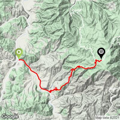
Kopaonik Southwest is the long way up Serbia's best-known mountain: 28.9 km (18.0 mi) from the town of Raška at 402 m (1,319 ft) to the Kopaonik ski resort at 1716 m (5,630 ft), with 1411 m (4,628 ft) of total gain. The overall average of 4.6% is misleading - the first 9 km (5.6 mi) run almost flat along the Ibar valley to Rudnica, and from there the road gains nearly 1300 m in about 20 km (12.4 mi), averaging around 6.5% with several kilometers at 10% or more.
The Rudnica side is the most popular road route up the mountain. It leaves the valley through small farming villages, then climbs through forest onto the high ground of Kopaonik National Park, which was established in 1981 and protects the mountain's upper slopes. The finish is in the heart of the resort - the largest ski area in Serbia, with hotels and cafes open in summer as well as winter.
If you still have legs at the finish, the road continues higher toward Pančić's Peak (2017 m / 6,617 ft), the highest point of the mountain. PJAMM also has separate northwest and northeast routes up Kopaonik if you want to ride the mountain from another side.
PLAN YOUR ROUTE
 We've partnered with Sherpa-Map.com to bring you the best route planning tool. With a PRO Membership you can use this climb as a reference when creating your route.
 This climb comes in two distinct parts. The first 9 km (5.6 mi), from Raška to Rudnica, gain only about 40 m in total - a flat warm-up along the Ibar valley, with one short dip before Rudnica.
The climbing proper starts at Rudnica. The first 5 km out of the valley run at 5-9%, then there's a flat breather of about 2 km near Šipačina before the hardest section of the climb: the steepest kilometer averages 12.1%, and the steepest half-kilometer 13.9%, on the stretch above Šipačina, with three consecutive kilometers averaging around 10%.
The upper road into the resort alternates between 4% and 9-10% kilometers, easing over the final 3 km (1.9 mi) to around 4% as you roll into the resort at 1716 m (5,630 ft).
Roadway: The road is paved throughout. The first section follows the main road along the Ibar valley from Raška to Rudnica; from Rudnica you turn onto the state road that climbs through the forest to the resort. The road is kept open in winter for the ski resort, but Kopaonik gets heavy snow and snow cover lasts for months, so treat this as a late-spring to early-autumn ride and expect patching and repair work after the winter.
Traffic: This is one of the main access roads to Serbia's largest ski resort, so it is not a quiet road - expect steady car traffic and some trucks, especially on weekends and holidays in both the summer and ski seasons, and rider reports mention construction traffic as well. The valley section from Raška to Rudnica shares the main road and is the busiest part of the ride. An early-morning start is the best way to avoid both traffic and summer heat in the valley.
Parking: Raška is a small town at the junction of the Raška and Ibar valleys, and the town center near the start is the practical place to leave a car. Riders who want to skip the flat valley section can start from Rudnica instead, which is where the real climbing begins.
There's little along the climb itself between the valley villages and the top, so fill bottles and pick up food in Raška before you start. The resort at the finish has hotels, restaurants and cafes, making it an easy place to refuel before the descent.
The steepest ramps above Šipačina reach double digits, so a compact crankset with a 30- or 32-tooth cog is a sensible setup. You'll finish more than 1300 m higher than you started, and the resort sits at over 1700 m, so pack a jacket or gilet for the long descent even on a hot day in the valley.
Before heading out on any cycling adventure check out our Things to Bring on a Cycling Trip and use our interactive check list to ensure you don't forget anything.
Raška shares its name with the medieval Serbian state of Raška, and the surrounding region is rich in medieval monasteries. Studenica Monastery, a UNESCO World Heritage Site, lies up the Ibar valley to the north, and Sopoćani Monastery and the remains of Stari Ras - also on the UNESCO list - are near Novi Pazar to the southwest. Either makes a worthwhile rest-day trip.
The Kopaonik resort itself is the obvious base for a cycling trip, with plenty of accommodation that stays open in summer. The nearest airport is Morava Airport near Kraljevo, about 100 km (62 mi) away; Niš Airport is about 127 km (79 mi) from the resort.
Conditions at 1700 m can be very different from the Ibar valley - check the forecast for the top of the climb with our Weather tool before you set out.
ROUTE MAP
MEMBER RATING
CURRENT WEATHER
PJAMM TRIPS ADVENTURE STARTER BUNDLES
Check out PJAMM Adventure's prepackaged (self-guided) cycling trips. They will help you plan, document and conquer your next adventure.
NEARBY CLIMBS (0) RADIAL PROXIMITY
FROM No Climbs Found
MEMBER REVIEWS & COMMENTS
Let us know what you thought of this climb. Signup for our FREE membership to write a review or post a comment.
Already have an account?
LOG IN HERE
