

21.3
PDI
21.9 mi
DISTANCE
4,816 ft
GAINED
3.8 %
AVG. GRADE
FULL CLIMB STATS
INTRO
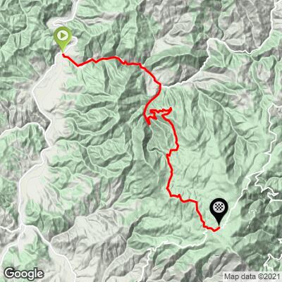
Kopaonik Northwest is the longest of our three routes up Serbia's best-known mountain: 35.2 km (21.9 mi) and 1,468 m (4,816 ft) of total gain from the village of Biljanovac, at 375 m (1,231 ft) in Raška municipality, to the Kopaonik ski resort at 1,716 m (5,630 ft). The 3.8% average is deceptive - the steepest 500 m averages 13.0% and the steepest 91 m (100 yd) reaches 17.5%.
Kopaonik was once called the Silver Mountain for its ore deposits, and mining on it goes back thousands of years. Winters are long, with snow cover lasting more than 160 days a year, so the ride season runs from late spring to early autumn.
Our Kopaonik Northeast and Southwest pages cover the other two ways up.
PLAN YOUR ROUTE
 We've partnered with Sherpa-Map.com to bring you the best route planning tool. With a PRO Membership you can use this climb as a reference when creating your route.
 Kopaonik Northwest covers 35.2 km (21.9 mi) and gains 1,468 m (4,816 ft) in total, rising from 375 m (1,231 ft) at the start to 1,716 m (5,630 ft) at the resort, a net climb of 1,341 m (4,399 ft) at an average grade of 3.8%.
The average spreads the effort unevenly. The steepest 10 km average 6.4%, the steepest 5 km 7.3%, the steepest 2 km 7.9% and the steepest kilometer 8.7%. The short pitches are much harder: the steepest quarter-mile (0.4 km) averages 14.6%, the steepest 500 m 13.0%, and the steepest 91 m (100 yd) reaches 17.5%.
Expect long moderate sections broken up by short, sharp ramps, so pace the early pitches.
Roadway: The climb is paved from the start to the resort. Kopaonik has long winters, with snow cover lasting more than 160 days a year, so treat this as a late-spring to early-autumn ride and expect some patching after the winter.
Traffic: Traffic builds as you near the resort, which is the destination for most vehicles on the mountain, and it is busiest on weekends and holidays in both the ski season and summer. Starting early avoids both the traffic and the midday heat.
Parking: Biljanovac is a small village (587 residents at the 2002 census) in Raška municipality with no trailhead lot, so look for roadside space in the village and keep the car clear of driveways and the road. The town of Raška, where our Kopaonik Southwest route starts, is the larger town base in the area.
Provisions: Carry food and water for the full 35.2 km (21.9 mi) - the climb starts in a village, and the resort at the top, with its hotels, restaurants and cafes, is the reliable place to refuel.
Gear: Short ramps of 13% and more call for a compact crankset and a 30- or 32-tooth cog. The finish is 1,341 m (4,399 ft) above the start, so pack a jacket for the descent.
Before heading out on any cycling adventure check out our Things to Bring on a Cycling Trip and use our interactive check list to ensure you don't forget anything.
Kopaonik's old name, the Silver Mountain, comes from its ore deposits; medieval Serbian rulers built fortresses in the surrounding region, including Maglič castle on the Ibar. The mountain gets over 200 sunny days a year, and in 2021 thirty red deer were reintroduced to the park after the species had died out there in 1856.
Jošanička Banja, a spa village in the same municipality about 30 km (18.6 mi) from Raška town, has three marked walking and cycling trails that suit an easy recovery day. For the drive in, Raška is 252 km (156.6 mi) from Belgrade by the Ibar highway and the resort is 270 km (167.8 mi).
Conditions at 1,700 m can be very different from the valley, so check the forecast for the top with our Weather tool before you set out.
ROUTE MAP
MEMBER RATING
CURRENT WEATHER
PJAMM TRIPS ADVENTURE STARTER BUNDLES
Check out PJAMM Adventure's prepackaged (self-guided) cycling trips. They will help you plan, document and conquer your next adventure.
NEARBY CLIMBS (0) RADIAL PROXIMITY
FROM No Climbs Found
MEMBER REVIEWS & COMMENTS
Let us know what you thought of this climb. Signup for our FREE membership to write a review or post a comment.
Already have an account?
LOG IN HERE
