Cycling Minaun Heights, Ireland
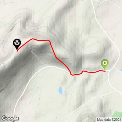
Ride 4.3 kilometers gaining 403 meters at 9.5% average grade.
They say the view from the top of this climb is exceptional. Unfortunately, our Minaun climb day was one of two bad weather days we experienced on our UK/Ireland 80 climb trip in July 2022. Regardless of a lack of views, this is a very, very hard bike climb - averaging 9.5% with a full kilometer averaging 16.5%.

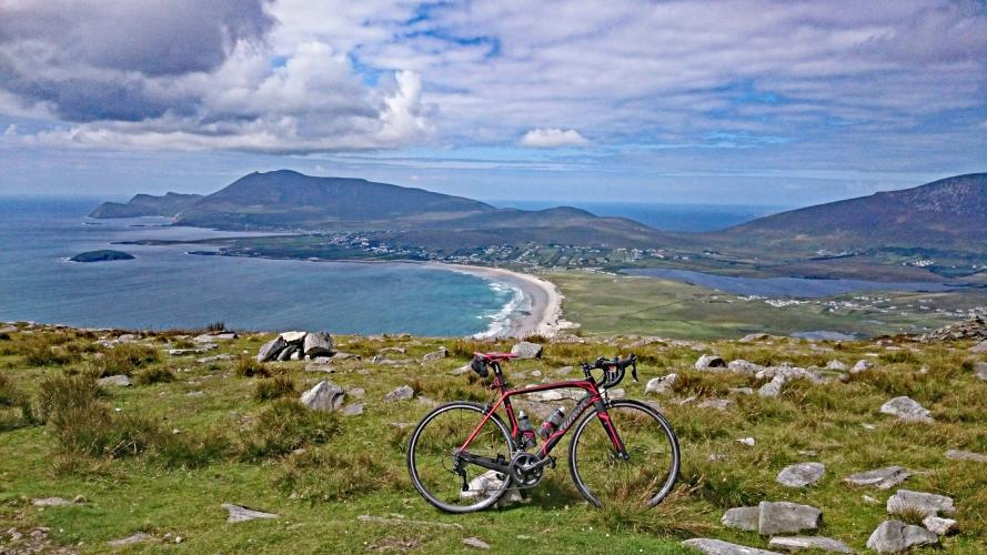
Bottom right photo is from Stephen Rochford on a clear day.
Climb summary by PJAMM Cycling’s Brad Butterfield (July 2022):
Minaun road is located just about as far west as one can reach in the Country of Ireland. It is a magnificent drive to reach this remote coastal town. Apart from a few gas stations and general stores, there isn’t much development out in the Achill Sound area, which is a real treat. It felt that the region has been relatively untouched by the modern world. The climb is on a narrow and fantastically steep road that takes you up to a couple of radio towers. If granted a clear day, the views of the Irish coastline are sure to be unforgettable. On the day that we rode, the weather was fully Irish -- which is to say, less than sunny. Cyclists certainly make it out to this road, as there are a number of ‘steep descent’ and ‘caution!’ warnings spray painted on the road.

The climb begins by climbing up Mweelin Road just past its T intersection with R319 (Wild Atlantic Way).
Climb summary by PJAMM Ireland ambassador Stephen Rochford, of Longwood, County of Meath, Ireland:
The Minaun climb is a fantastic ride just off the famous Wild Atlantic Way in Achill Island, off the west coast of Ireland. The climb starts gently once you turn off the R139, with the first kilometer averaging little more than 2%. However, as you approach the right-hand turn that takes you to the top, it increases to between 6 and 10%. From this turn it is slightly over 2.5 kilometers to the top.

Once you take the turn things get very spicy, very quickly. The road pitches up into what seems like a wall. You are hit with a kilometer that averages nearly 17%, pretty much on par with the steepest kilometers of legendary climbs like the Angliru, Zoncolan, or Mortirolo. You might find yourself weaving from side to side on the road trying to keep moving, made all the trickier due to the narrow width and poor surface. Thankfully for your legs, this kilometer is by far the worst part of the climb, and once it starts to ease the last kilometer is much more manageable at between 6 and 7% with a kick up towards 10% right again at the very end.


PJAMM Cycling’s profile of The Wall.
Now it's time to relax and soak in the amazing scene visible from the top. As you look down across Keel Strand you can see that this truly is the Wild Atlantic Way in all its glory.

The Minaun view on a clear day.
Good places to park in the area are in the villages of Achill Sound, Doogort, or Keel, which will each give about 10 kilometers to get the legs ready. Another longer but highly recommended option is to make this climb as part of a trip along the Atlantic Greenway, which runs from Westport all the way to Keem Strand. The full distance from Westport is 50 kilometers to the start of the climb, but there are several towns along the route closer to the climb. This is one of the top cycling routes in the country, running on a closed cycling path for most of its duration alongside the stunning backdrop of Clew Bay and its hundreds of islands. If you have the time it is well worth the effort and after the climb you can continue to Keem Strand, where you really feel you are standing at the edge of the world.

Finish on a foggy day. 😞