
18.1
PDI
12.3 mi
DISTANCE
3,409 ft
GAINED
5.2 %
AVG. GRADE
FULL CLIMB STATS
INTRO
This is the Italian side of the Col de Tende - the Colle di Tenda - and the paved way up. Our route runs 19.9 km (12.3 mi) from Vernante with 1039 m (3,409 ft) of gain at a 5.2% average, rising from 743 m (2,438 ft) to 1782 m (5,846 ft) where the Italian asphalt ends at the French border, about 90 m below the col itself at 1871 m (6,138 ft).
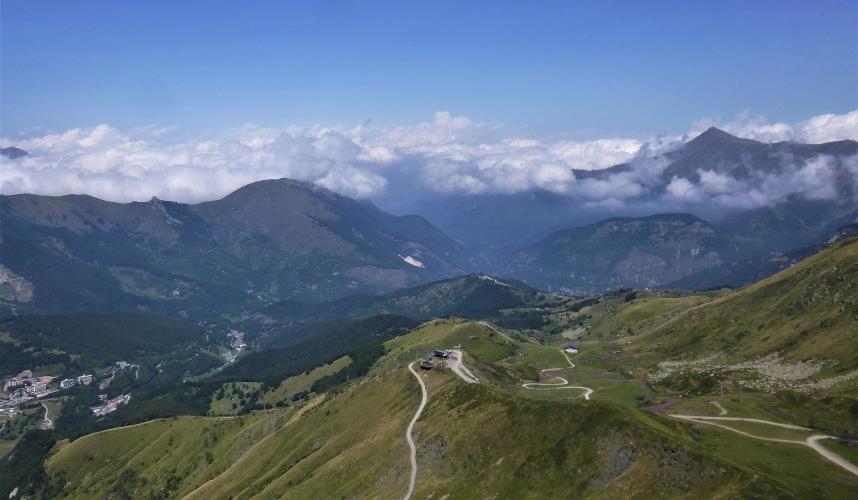
It is really two climbs. The first 8 km (5.0 mi) follow the SS20 up the Valle Vermenagna through Limone Piemonte at a gentle 2-4%. Past Limone the grade builds, and near the road tunnel's entrance the old pass road takes over, zigzagging up open pastureland with the 19th-century forts of the Colle di Tenda - Forte Centrale above the col, Forte Taborda on the ridge - coming into view. The last 6 km (3.7 mi) hold 6-7.5% with almost no relief.
The road tunnel has never been open to bikes, so this old road has always been the cyclist's way over, and with cars in the tunnel the upper hairpins are quiet. Riders report the Italian side was fully asphalted to the top around 2019 and freshly resurfaced since. The French side beyond the border is the rough historic road covered on our Col de Tende (France) page. The Tour de France crossed this pass from the Italian side in 1952 and 1961.
PLAN YOUR ROUTE
 We've partnered with Sherpa-Map.com to bring you the best route planning tool. With a PRO Membership you can use this climb as a reference when creating your route.
The Italian side of the Col de Tende climbs 19.9 km (12.3 mi) at a 5.2% average, gaining 1039 m (3,409 ft) from 743 m (2,438 ft) to 1782 m (5,846 ft).
The two halves of the climb feel very different. The first 8 km (5.0 mi), up the SS20 from Vernante through Limone Piemonte, rarely top 4% - kilometers 1 through 8 run between 2.3% and 4.2%. The road then steepens past Limone: kilometer 9 averages about 6.0%, and kilometers 11 to 13 are the hardest section of the climb at 6.2%, 7.3% and 8.1%.
On the old pass road from about km 14, the grade settles into a steady 6.2-7.4% for the final 6 km (3.7 mi) of hairpins to the border. The steepest kilometer averages 8.1%, the steepest 500 m (0.3 mi) 8.4%, the steepest 5 km (3.1 mi) 6.9% and the steepest 10 km (6.2 mi) 6.8%. The steepest 91 m (100 yd) reach 8.9%.
Roadway: Asphalt from Vernante right up to the border. The lower half is the SS20 state road, wide and well surfaced; the upper half is the old pass road, narrower and full of hairpins, which riders report was fully asphalted to the top around 2019 and freshly resurfaced since. Bikes are not allowed in the road tunnel, so you must take the old road. The pavement ends at the border, and the last stretch to the col and the descent into France are rough and partly unpaved - turn around here on a road bike. At this height snow can cover the upper road well outside the summer months.
Traffic: The SS20 from Vernante to Limone is the main road to the tunnel and France and can be busy, trucks included, when the tunnel is open. The tunnel was shut completely for works from 21 September to 29 October 2026; it was set to reopen on limited hours from 30 October and with no time restrictions from 30 November 2026, so traffic on the lower road rises and falls with the tunnel timetable. Once you leave the SS20 for the old pass road, traffic drops to almost nothing.
Parking: Vernante is a small village on the SS20, so park in the village center rather than on the main road. Limone Piemonte, 7 km (4.3 mi) up the climb, is a resort town with more room to park if you prefer a shorter ride, and the Limone Piemonte railway station on the Cuneo-Ventimiglia line makes it possible to arrive by train.
Provisions: Vernante and Limone Piemonte both have bars, bakeries and shops, and Limone is the last real stop before the long upper climb - fill your bottles there. The old pass road has no reliable services.
Gear: The gentle first half is fine on any gearing, but the final 10 km (6.2 mi) average close to 7%, so bring low gears - something close to a 1:1 bottom ratio keeps you turning over above Limonetto. The border sits at nearly 1800 m (5,900 ft) on an exposed ridge where afternoon storms build quickly in summer, so carry a windproof jacket for the long descent.
Before heading out on any cycling adventure check out our Things to Bring on a Cycling Trip and use our interactive check list to ensure you don't forget anything.
Vernante calls itself the village of Pinocchio. Since 1989, local artisans Bruno Carletto and Bartolomeo Cavallera have painted more than 150 murals on the walls of the old center, all based on the illustrations of Attilio Mussino, who drew the first full-color edition of Collodi's book - worth a slow lap with a coffee once you're back down. Limone Piemonte, halfway up, has been a ski town since the railway arrived in 1891, and its Riserva Bianca ski area links Limone-Sole, Tre Amis and Limonetto.
At the top, the forts of the Colle di Tenda are worth a walk: Forte Centrale guards the col, and Forte Taborda and Forte Pepino sit on the ridge to the east, all built by Italian military engineers in the 1880s and never used in combat. For Tende and the Roya valley on the French side, see our Col de Tende (France) page.
ROUTE MAP

MEMBER RATING
CURRENT WEATHER
PJAMM TRIPS ADVENTURE STARTER BUNDLES
Check out PJAMM Adventure's prepackaged (self-guided) cycling trips. They will help you plan, document and conquer your next adventure.
NEARBY CLIMBS (0) RADIAL PROXIMITY
FROM No Climbs Found
MEMBER REVIEWS & COMMENTS
Let us know what you thought of this climb. Signup for our FREE membership to write a review or post a comment.
Already have an account?
LOG IN HERE
