
19.9
PDI
10.1 mi
DISTANCE
3,322 ft
GAINED
6.3 %
AVG. GRADE
FULL CLIMB STATS
INTRO
The Col de Tende climbs 16.2 km (10.1 mi) from the village of Tende, in France's Roya valley, to the Italian border, gaining 1,013 m (3,322 ft) at a 6.3% average grade. Our route runs from 842 m (2,764 ft) to 1,855 m (6,087 ft), just below the col itself at 1,871 m (6,138 ft). The first stretch follows the D6204 toward Vievola and the road tunnel; just before the portal, you turn off onto the old pass road, which zigzags up the mountain through dozens of hairpins.
This is not a smooth tarmac pass. The lower road is paved, but the old road becomes rough and gravelly higher up, and the final kilometers are the roughest. The 3.2 km (2.0 mi) road tunnel, opened in 1882, is closed to bicycles, so the old road is the way over. That is also why it is so quiet: most vehicles take the tunnel, and you can ride for long stretches with the mountain to yourself.
The col has carried traffic since the Middle Ages, when salt caravans crossed it, and the ridge above is lined with forts built between 1877 and 1880, six of them now on French territory. The Tour de France crossed the pass twice, from the Italian side, in 1952 and 1961. Tende itself only became French in 1947, and under the treaty of that year the col lies entirely inside France.
PLAN YOUR ROUTE
 We've partnered with Sherpa-Map.com to bring you the best route planning tool. With a PRO Membership you can use this climb as a reference when creating your route.
The climb averages 6.3% over 16.2 km (10.1 mi), but the effort is back-loaded. The paved lower section is gentler, and the old pass road above the tunnel turn-off averages close to 9%, with the ramps getting longer as you gain height.
The steepest 91 m (100 yd) reaches 13.0%, the steepest 0.5 km (0.3 mi) averages 11.3%, and the steepest 1 km (0.6 mi) averages 9.6%. Over the hardest 5 km (3.1 mi), the grade averages 8.1%, and over the hardest 10 km (6.2 mi) it averages 7.4%. Rough gravel on the upper section makes it feel steeper than the numbers suggest, so pace the lower kilometers with the top in mind.
Roadway: The route starts on paved road, then switches to the old pass road with its long series of hairpins (accounts count anywhere from 46 to nearly 60). The old road is surfaced in places and gravel in others, and accounts differ on exactly where the pavement ends, but the top 4 km (2.5 mi) or so is rough and loose. A road bike can manage it on wider tires with care; a gravel or mountain bike is far more comfortable, and the descent is harder than the climb. Riders also report roadworks in the first few kilometers, so expect some disruption in the valley. The pass is high enough for frequent summer thunderstorms, and snow can close the upper road outside summer.
Traffic: Light on the old road, since cars and trucks use the tunnel. The first kilometers on the D6204 toward Vievola share the road with valley traffic. The tunnel itself is not open to bicycles, and it has periodic works closures, so do not plan on using it as an escape route.
Parking: Tende is a small mountain town, and the Place du Général de Gaulle, its central square, has free parking nearby plus an e-bike charging point. From there, ride out of town along the D6204 toward Vievola to reach the start. Tende also has a TER train station on the Nice-Breil-Tende line, which is a practical way to reach the start without a car.
Provisions: Stock up in Tende before you ride, because there are no services on the old road. Carry two full bottles and food for a ride that takes most cyclists well over an hour and a half, and more on gravel.
Gear: A compact crankset or a wide-range cassette is worth having for the ramps on the old road. Choose the widest tires your bike can take, and carry a spare tube and a pump, since riders report punctures on the rough top section. The pass is often windy and storms build quickly in summer, so pack a windproof layer and be ready to turn around if the sky darkens.
Before heading out on any cycling adventure check out our Things to Bring on a Cycling Trip and use our interactive check list to ensure you don't forget anything.
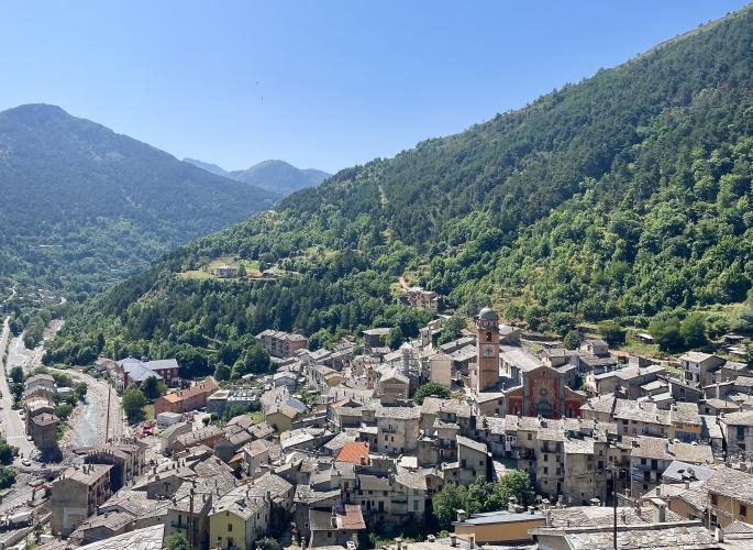
Tende is worth an hour either side of the ride. The Collégiale Notre-Dame-de-l'Assomption, consecrated in 1518, has a colorful Renaissance facade and a portal made from the local green schist, and the tall dark houses of the old town are roofed in stepped schist slate. The Musée départemental des Merveilles, opened in 1996, displays casts of the Bronze Age rock engravings of the Vallée des Merveilles, a valley holding more than 36,000 recorded engravings. On Wednesday mornings a producers' market fills the Place du Général de Gaulle.
The Roya valley was hit hard by Storm Alex in October 2020, and repair and rebuilding work along the valley roads has continued since, so check current road and tunnel notices before you travel. If you want to pair the pass with a trip over to Italy, the descent runs down to Limone Piemonte on the far side. See other climbs nearby, or build a custom route from here, with our Routes in the Area tool.
ROUTE MAP

MEMBER RATING
CURRENT WEATHER
PJAMM TRIPS ADVENTURE STARTER BUNDLES
Check out PJAMM Adventure's prepackaged (self-guided) cycling trips. They will help you plan, document and conquer your next adventure.
NEARBY CLIMBS (0) RADIAL PROXIMITY
FROM No Climbs Found
MEMBER REVIEWS & COMMENTS
Let us know what you thought of this climb. Signup for our FREE membership to write a review or post a comment.
Already have an account?
LOG IN HERE
