
29.5
PDI
18.3 mi
DISTANCE
5,303 ft
GAINED
5.4 %
AVG. GRADE
FULL CLIMB STATS
INTRO
PLAN YOUR ROUTE
 We've partnered with Sherpa-Map.com to bring you the best route planning tool. With a PRO Membership you can use this climb as a reference when creating your route.
 Passo della Forcola averages 5.4% over 29.5 km (18.3 mi) of climbing and 1,617 m (5,303 ft) of gain, but the two halves of the ride feel different. The steepest 100 yards reaches 11.2%, and sustained over a full kilometer, the steepest section still holds 10.1%.
Widen the window and the number eases: the steepest 5 km stretch settles to 8.1%, and over 10 km, 7.7%. The independent final 4.3 km beyond the split with Bernina Pass averages a sharper 7.8% - noticeably harder than the 5.4% average for the ride as a whole, which means the last half-hour of this climb is tougher than everything that came before it.
Roadway: The road is paved the entire way from Brusio to the finish, and riders describe it as being in good condition, though narrower than the main Bernina Pass road once the two routes split around km 25. The pass is seasonal - typically closed by snow from around October through May - so plan this as a summer-into-early-autumn ride and check current conditions before heading out in shoulder season.
Traffic: Traffic is moderate for the first 25 km on shared Route 29, the main road up the Val Poschiavo. Once the road splits off toward the Forcola pass, traffic drops noticeably - most cars and tour coaches continue straight on toward the Bernina Pass summit and St. Moritz rather than making the turn, leaving the final climb quieter and narrower.
Parking: Brusio's village center has informal roadside parking near the train station and the spiral viaduct viewpoint, the same start used by the neighboring Bernina Pass and Forcola di Livigno climbs. Riders from Tirano, Italy (about 15 minutes south) or based in Poschiavo can also start partway up the valley to skip the lower, flatter miles.
Poschiavo, about a third of the way up, is the last town with grocery stores, cafes, and a pharmacy - top off water and food there, since nothing else follows for the remaining climb to the pass. A compact crank or wide-range cassette is worth having for the steeper final 4.3 km, which averages 7.8% after more than 25 km already in the legs.
Because the pass sits above 2,250 m, temperatures and wind at the top can be sharply colder than a warm morning in Brusio - pack a real layer, especially if you're descending back down rather than continuing over the border into Italy.
Before heading out on any cycling adventure check out our Things to Bring on a Cycling Trip and use our interactive check list to ensure you don't forget anything.
Brusio, Poschiavo, and the Bernina Express corridor are covered in more depth on the neighboring Bernina Pass and Forcola di Livigno climb pages, since all three routes share the same Brusio start and lower valley. Worth repeating here: Poschiavo, about a third of the way up, is one of the best-preserved historic town centers in Graubunden, with Italian-influenced architecture distinct from most Swiss Alpine villages.
This climb's own finish sits just below the actual Passo della Forcola summit, in a quieter, narrower stretch of road than the main Bernina Pass route - a good option for riders who want the high-mountain scenery of a Forcola pass ascent without the Bernina road's heavier tour-bus traffic. Riders staying in the area for a few days can pair this with the neighboring climbs sharing the same start - see our Routes in the Area tool for other climbs nearby.
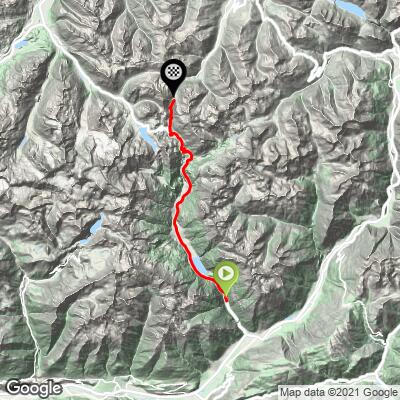
ROUTE MAP
MEMBER RATING
CURRENT WEATHER
PJAMM TRIPS ADVENTURE STARTER BUNDLES
Check out PJAMM Adventure's prepackaged (self-guided) cycling trips. They will help you plan, document and conquer your next adventure.
NEARBY CLIMBS (0) RADIAL PROXIMITY
FROM No Climbs Found
MEMBER REVIEWS & COMMENTS
Let us know what you thought of this climb. Signup for our FREE membership to write a review or post a comment.
Already have an account?
LOG IN HERE
