
20.9
PDI
10.6 mi
DISTANCE
3,453 ft
GAINED
6.1 %
AVG. GRADE
FULL CLIMB STATS
INTRO
Passo Valparola from Caprile is one of the tougher climbs in the Dolomites: 17.0 km (10.6 mi) and 1052 m (3,453 ft) of gain at an average grade of 6.1%, rising from 1166 m (3,824 ft) to 2195 m (7,203 ft). By our rankings it is #898 in the world. Most of the climb shares the road with Passo Falzarego, and Falzarego's summit sits only about 1.2 km (0.7 mi) from the Valparola pass.
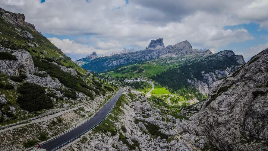
The average is gentle, but the finish is not: the steepest kilometer (0.6 mi) averages 9.0% and the steepest 500 m (0.3 mi) 10.3%. The road climbs through numbered hairpins above the tree line and, near the top of the Falzarego road, through two galleries and a short rock tunnel, with the Dolomite walls closing in on both sides.
At the pass, the Forte Tre Sassi sits at 2197 m (7,208 ft) between Sass de Stria and Piccolo Lagazuoi. Austria built it around the turn of the 20th century to guard this crossing, and it is now a Great War museum. The Giro d'Italia has climbed Valparola since 1976, and it is the last of the seven passes on the Maratona dles Dolomites.
PLAN YOUR ROUTE
 We've partnered with Sherpa-Map.com to bring you the best route planning tool. With a PRO Membership you can use this climb as a reference when creating your route.
 Passo Valparola (Caprile) covers 17.0 km (10.6 mi) and gains 1052 m (3,453 ft) in total, rising from 1166 m (3,824 ft) to 2195 m (7,203 ft) at an average grade of 6.1%.
The effort builds toward the top: the steepest 10 km (6.2 mi) average 6.5%, the steepest 5 km (3.1 mi) 6.8%, the steepest 2 km (1.2 mi) 7.8%, the steepest kilometer (0.6 mi) 9.0% and the steepest 500 m (0.3 mi) 10.3%. The steepest 91 m (100 yd) reaches 10.9%.
Because the gradients are moderate for most of the day, this is a climb to ride at an even tempo and save something for the final ramps, where altitude over 2000 m (6,562 ft) takes its toll.
Roadway: The route follows the Via Col di Lana and then the SR48 up the Falzarego road. Riders on climbfinder rate the surface mostly great or okay, with some describing brand-new asphalt, and the road is paved all the way. Roadworks were reported on the final kilometers of the Falzarego climb in 2023, so expect the occasional patched section near the top. This is a high-altitude road, so snow and ice can affect it early and late in the season - check current conditions before an early- or late-season ride.
Traffic: Traffic is light to moderate through most of the climb, and rises noticeably at the top, where Passo Falzarego is a busy tourist junction of three roads with a cable car, parking and food. On the Dolomites Bike Day, Falzarego, Valparola and Campolongo are closed to motor traffic from 9:00 a.m. to 3:00 p.m.; the next edition is listed for 19 June 2027.
Parking: Most riders start in Caprile, where roadside parking near the village center is straightforward (our Passo Fedaia page covers it in more detail). At the top, the Rifugio Passo Valparola has a bar and restaurant, and Falzarego's summit has parking and food and drink if you want a second stop.
Provisions: Fill two bottles in Caprile and carry a few bars for the long middle section. At Falzarego you will find food and drink at the summit, and the Rifugio Passo Valparola has a bar and restaurant at the finish.
Gear: A compact crankset with a 28-tooth or larger cog is plenty for the 6.1% average, though the final ramps near 10% reward a little extra gearing at over 2000 m (6,562 ft). Carry a front and rear light - the Falzarego road passes through galleries and a short rock tunnel near the top - and a windproof layer for the descent.
Weather: Check conditions before you go: the pass is exposed, and afternoon storms in the Dolomites build quickly.
Before heading out on any cycling adventure check out our Things to Bring on a Cycling Trip and use our interactive check list to ensure you don't forget anything.
The summit area is one of the best places in the Dolomites to understand the Great War. The Forte Tre Sassi museum (opened 2003) shows relics from the Austro-Hungarian fortress and the surrounding front, and the cable car at Passo Falzarego - just 1.2 km (0.7 mi) away - serves Lagazuoi, whose hiking trails include the Kaiserjager path. Nearby Col di Lana (2462 m / 8,077 ft), reached from Pieve di Livinallongo, had its summit blown apart by a mine in April 1916.
For riders staying in Caprile, the Passo Fedaia and Passo Giau pages cover the village, the Serrai di Sottoguda gorge and the Val Fiorentina side, so here the extras are on the other side of the Falzarego junction: from the top you can drop down toward Cortina or take the Valparola descent toward La Villa and Corvara, and tie in the Sella Ronda.
See other climbs nearby, or build a custom route linking Valparola with Falzarego, Giau and the Sella passes, with our Routes in the Area tool.
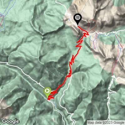
ROUTE MAP
MEMBER RATING
CURRENT WEATHER
PJAMM TRIPS ADVENTURE STARTER BUNDLES
Check out PJAMM Adventure's prepackaged (self-guided) cycling trips. They will help you plan, document and conquer your next adventure.
NEARBY CLIMBS (0) RADIAL PROXIMITY
FROM No Climbs Found
MEMBER REVIEWS & COMMENTS
Let us know what you thought of this climb. Signup for our FREE membership to write a review or post a comment.
Already have an account?
LOG IN HERE
