

16.9
PDI
7 mi
DISTANCE
2,641 ft
GAINED
7 %
AVG. GRADE
FULL CLIMB STATS
Page Contributor(s): Charlie Thackeray, Ongar, England; Bruce Hamilton, La Quinta, CA, USA.
INTRO
Manigod is the hinge of this climb. Below the village the D16 is a fair warm-up out of Thônes; above it, the road turns into the hairpins where the Tour de France sorted out who would lead over the top in 2023 - Giulio Ciccone, on his way to the mountains jersey. The Croix Fry has been in the Tour six times since 1994, and this is the side the race uses: 11.2 km (7.0 mi) from the D16 turnoff to the col at 1467 m, with 805 m (2641 ft) of climbing at 7.0%.
The first 3 km climb steadily at a bit over 7%. Then the road nearly levels off for 2 km through Villard-Dessous and into Manigod, a spread-out village of wooden chalets with a bakery right on the road. Don't get comfortable. The 3 km above the village are the hardest of the day, averaging about 9.5% with one kilometer close to 11%, and there's very little shade on them. The last 3 km ease back to around 7% through meadows and chalets, with La Tournette across the valley behind you.
The col itself is a small ski hamlet more than a lonely pass: a chairlift, three hotel-restaurants, big car parks and a standing stone that local legend says Saint Francis de Sales marked with four crosses when he came through in 1607. Carry on over the top and you drop to La Clusaz; turn right at the col for the quieter dead-end road to the Col de Merdassier.
PLAN YOUR ROUTE
 We've partnered with Sherpa-Map.com to bring you the best route planning tool. With a PRO Membership you can use this climb as a reference when creating your route.
From the D16 turnoff south of Thônes (660 m) to the Col de la Croix Fry at 1467 m (4813 ft), the climb covers 11.2 km (7.0 mi) and gains 805 m (2641 ft) at an average of 7.0%. The steepest kilometer averages 10.8%, the steepest 2 km 10.1% and the steepest 5 km 8.6%.
Km 0-3: 7.3%, steady climbing on the D16 up the valley toward Manigod.
Km 3-5: 2.9%, almost flat through Villard-Dessous and into Manigod - catch your breath here.
Km 5-8: 9.4%, the hairpins above Manigod and the crux of the climb; the kilometer just out of the village is close to 11%.
Km 8-11.2: 7.1%, a steadier finish past meadows and chalets to the col.
Roadway: The D16 is a two-lane departmental road, paved throughout, and riders who have done it in the last few years describe the asphalt as good to excellent. The hairpins above Manigod are wide and well graded but open to the sun. The road is kept open in winter for the Croix Fry ski area, but expect snow and ice at the col from December into spring - this is a May-to-October ride on a road bike.
Traffic: Usually light. July and August bring campervans, motorbikes and plenty of other riders using the Croix Fry as the link between Thônes and La Clusaz, though it stays quieter than the Col des Aravis next door. Ski season brings car and bus traffic up to the lifts.
Parking: Most riders park in Thônes and roll the 2 km out to the D16 turnoff. To skip the lower slopes, Manigod has a few small free car parks beside the D16 in the village center (map). At the col there are large free car parks by the lifts (map), but they fill up on summer weekends and in ski season.
Gear: The flat stretch into Manigod makes the next 3 km feel harder than the numbers say. A 34x30 lets you sit and turn the pedals on the 10% hairpins. There's not much shade on this side, so on a hot day go early, and bring a layer for the descent - riders have topped out here in cloud at 5°C in May.
Provisions: Manigod is the refill point: the bakery La Manigodine is right on the D16 through the village (it usually closes Wednesdays), with a café and a bistro a few steps away. At the col, Les Sapins, Les Rosières and the Chalets-Hôtel de la Croix Fry all serve food in season; the Chalets-Hôtel, run by the same family for four generations, opens in summer from mid-June to mid-September.
Before heading out on any cycling adventure check out our Things to Bring on a Cycling Trip and use our interactive check list to ensure you don't forget anything.
Base yourself in Thônes or Manigod and you can ride a handful of Aravis climbs without loading the car: this one, the Col des Aravis from La Clusaz, the Col de Plan Bois out of Manigod and the Col de la Colombière from Le Grand-Bornand. The classic loop goes up the Croix Fry, down to La Clusaz and back to Thônes through Saint-Jean-de-Sixt - roughly 850 m of climbing whichever way you ride it, and the Manigod side is the harder way up.
For a stop with something to see, the Ferme de Lorette is a 45-minute walk from the col: 70 dairy cows, free self-guided visits in summer, a guided tour at 2:30 pm (book ahead), and a shop selling farmhouse Reblochon and the farm's own Tomme de Beauregard. Above the col, the Beauregard plateau is a protected stretch of forest, peat bog and pasture with walking paths and views to Mont Blanc, and it becomes 36 km of cross-country ski trails in winter.
Our Col de Merdassier page covers Thônes and the road beyond the Croix Fry.
ROUTE MAP

MEMBER RATING
CURRENT WEATHER
PJAMM TRIPS ADVENTURE STARTER BUNDLES
Check out PJAMM Adventure's prepackaged (self-guided) cycling trips. They will help you plan, document and conquer your next adventure.
NEARBY CLIMBS (0) RADIAL PROXIMITY
FROM No Climbs Found
MEMBER REVIEWS & COMMENTS
Let us know what you thought of this climb. Signup for our FREE membership to write a review or post a comment.
Already have an account?
LOG IN HERE
carlinguernsey
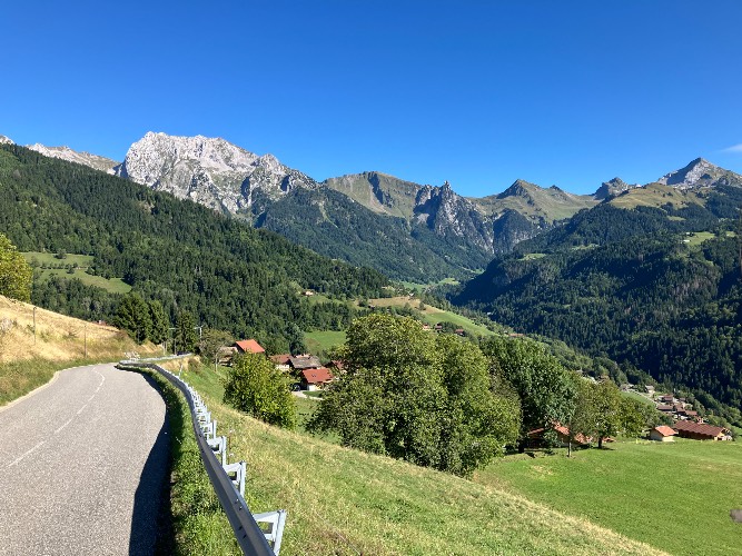
This is the type of climb that I think about on rainy winter days/nights on the trainer in the garage. It takes you up through a lovely valley surrounded by towering peaks. The hillsides are dotted with small villages and farms. This is a great one to save for a sunny day to take full advantage of the scenery. The gradient is hard in places, but not as difficult as some other Alpine climbs. There are restaurants and shops in Thones, Manigod, and at the top.
