8
PDI
6 mi
DISTANCE
1,608 ft
GAINED
5 %
AVG. GRADE
FULL CLIMB STATS
INTRO
This 6 mile bike climb is located in Provence-Alpes-Côte d'Azur, France. The average gradient is 5% and there is a total elevation gain of 1,608 ft, finishing at 1,653 ft.
Use the profile tool, route map, and weather forecast to conquer this cycling climb.
Use the profile tool, route map, and weather forecast to conquer this cycling climb.
PLAN YOUR ROUTE
This climb averages 0%. The steepest quarter mile of this climb is 0%. NaN miles of the climb is at or above 10% grade. The gradient on this climb is broken down as follows:
See more details and tools regarding this climb's grade via our interactive Profile Tool.
See more details and tools regarding this climb's grade via our interactive Profile Tool.
Information Not Available
If you have any information regarding this climb, we'd like to hear from you. Click the CONTRIBUTE button to share your thoughts with us.
Information Not Available
If you have any information regarding this climb, we'd like to hear from you. Click the CONTRIBUTE button to share your thoughts with us.
Before heading out on any cycling adventure check out our Things to Bring on a Cycling Trip and use our interactive check list to ensure you don't forget anything.
Information Not Available
If you have any information regarding this climb, we'd like to hear from you. Click the CONTRIBUTE button to share your thoughts with us.
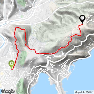
ROUTE MAP
MEMBER RATING
CURRENT WEATHER
PJAMM TRIPS ADVENTURE STARTER BUNDLES
Check out PJAMM Adventure's prepackaged (self-guided) cycling trips. They will help you plan, document and conquer your next adventure.
NEARBY CLIMBS (0) RADIAL PROXIMITY
FROM No Climbs Found
MEMBER REVIEWS & COMMENTS
Let us know what you thought of this climb. Signup for our FREE membership to write a review or post a comment.
Already have an account?
LOG IN HERE
MethowBiker
A nice 1.5 hour workout from Centre Ville Nice. A favorite of local cyclists. I prefer to start out on the basse (low) corniche, then just 1/2 mile up from the Port, turn sharp left up a skinny street to connect to the Moyen (middle corniche). Much less traffic. Use cycle.travel app to get the details.
Traffic is thick for about 1/2 mile, but if you use my recommended route, 95% of it disappears.
The views are stunning. You'll feel like you're in a helicopter. The Col itself has views to the north.
If you want a real challenge, take the left turn at the col to the "Park Maritimes". It's a one lane paved road that climbs another 1,100 feet in two miles. And the views there are just gobsmacking, 360 degrees.