
24.4
PDI
14.1 mi
DISTANCE
4,275 ft
GAINED
5.7 %
AVG. GRADE
FULL CLIMB STATS
Page Contributor(s): Sven Bartels, Berlin, Germany
INTRO
Lac de Cap-de-Long climbs 22.7 km (14.1 mi) out of Saint-Lary-Soulan in the Hautes-Pyrénées, gaining 1,303 m (4,275 ft) at a 5.7% average grade to a dam-fed alpine lake at roughly 2,160 m (7,090 ft) inside the Réserve Naturelle du Néouvielle. The first 9 km to the village of Fabian is a gentle warm-up shared with the neighboring climb to Lac d'Aumar, before the two routes split.
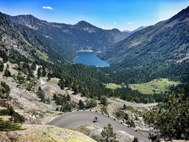
Past Fabian the road narrows into forest and the gradient turns genuinely irregular, working past Lac d'Orédon before a final 3 km of hairpins into the 10-12% range up to the Cap-de-Long dam. Unlike its sibling climb to Lac d'Aumar, this road isn't subject to the reserve's summer car-shuttle restriction, so it stays open to ordinary traffic the whole way - light traffic at that, since it's a dead-end road serving hikers and anglers headed for the lake.
The payoff is one of the more dramatic reservoirs in the Pyrenees - a curved dam wall holding back turquoise water below the Néouvielle massif. Many riders pair this climb with the nearby Lac d'Aumar/Lac d'Aubert road in the same outing, since both share the same first 9 km out of town.
The road is open roughly June through October and closed by snow the rest of the year - check current conditions before planning a visit outside summer.
PLAN YOUR ROUTE
 We've partnered with Sherpa-Map.com to bring you the best route planning tool. With a PRO Membership you can use this climb as a reference when creating your route.
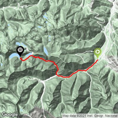
 From Saint-Lary-Soulan, Lac de Cap-de-Long climbs 22.7 km (14.1 mi) at an average grade of 5.7%, gaining 1,303 m (4,275 ft) to the dam above 2,150 m (7,050 ft).
The average understates the difficulty. The first 9 km to Fabian is nearly flat, a warm-up along the valley floor - which means essentially all of the climbing is packed into the remaining 13.7 km, with the final 3 km into a sustained 10-12% grade through the hairpins below the dam. Save something for that closing stretch.
Roadway: The road is paved throughout, though the surface gets rougher and narrower past Fabian - expect some bumpy tarmac and patched sections on the upper Route des Lacs, typical of a road built mainly for hikers, anglers, and the occasional maintenance vehicle rather than heavy traffic.
Traffic: Traffic is light. This is a dead-end road serving only the reserve and the dam, and - unlike the neighboring road to Lac d'Aumar and Lac d'Aubert - it isn't subject to the Néouvielle reserve's summer car-shuttle restriction, so it simply sees fewer vehicles overall rather than being closed to them at set hours.
Parking: Most riders start from the last roundabout on the edge of Saint-Lary-Soulan. There's also a parking area at Lac d'Orédon partway up if you'd rather drive the flatter lower section and ride only the steeper final push to the dam.
A standard road bike and gearing handle this climb fine, but pack an easy low gear - the final 3 km averages 10-12% after 19 km already in your legs, and that's not a place to discover you're a gear short. The road is paved the whole way, so no special tires are needed.
There's no food or water past Saint-Lary-Soulan and Fabian, so carry what you need for the full ride. The dam sits above 2,100 m, so bring a layer - it's noticeably colder and windier up there than in the valley, even on a warm summer day.
Before heading out on any cycling adventure check out our Things to Bring on a Cycling Trip and use our interactive check list to ensure you don't forget anything.
Saint-Lary-Soulan is one of the best-stocked base towns in the Pyrenees for stacking climbs - Pla d'Adet, Col d'Azet, and Piau-Engaly are all short rides away, and most locals pair this climb with the neighboring Lac d'Aumar road in the same day, since both share the first 9 km out of town before splitting at Fabian.
For lodging built around cycling, the Pyrenees Cycling Lodge in nearby Saint-Savin is a well-regarded option, though it's more of a base for the Argelès-Gazost-side climbs than this valley - Saint-Lary-Soulan itself has its own full range of hotels and gîtes if you're basing your trip in the Vallée d'Aure specifically. Our Routes in the Area tool is a good way to see the full stack of climbs reachable from town.
ROUTE MAP
MEMBER RATING
CURRENT WEATHER
PJAMM TRIPS ADVENTURE STARTER BUNDLES
Check out PJAMM Adventure's prepackaged (self-guided) cycling trips. They will help you plan, document and conquer your next adventure.
NEARBY CLIMBS (0) RADIAL PROXIMITY
FROM No Climbs Found
MEMBER REVIEWS & COMMENTS
Let us know what you thought of this climb. Signup for our FREE membership to write a review or post a comment.
Already have an account?
LOG IN HERE
carlinguernsey
This is not the most difficult ride, but once you turn off the main road the scenery gets better and better. The last few kilometers have some truly stunning scenery and the last part of the ride goes up some tight switchbacks next to the face of a dam. It feels like a real adventure!
