
25.2
PDI
8.4 mi
DISTANCE
3,530 ft
GAINED
7.8 %
AVG. GRADE
FULL CLIMB STATS
Page Contributor(s): Luke Hise, AZ
INTRO
Passo Fedaia climbs out of Caprile, in the Cordevole valley of the Belluno Dolomites, to the 2,062.1 m (6,764 ft) pass at the foot of the Marmolada, the highest peak in the Dolomites. From the village the route covers 13.6 km (8.4 mi) and gains 1,076.1 m (3,530 ft) at a 7.8% average grade.
The first 9 km are deceptively gentle, following the Cordevole and then the Pettorina river through the Serrai di Sottoguda, a narrow limestone gorge, to Malga Ciapela, where the cable car departs for the Marmolada glacier. Just past Malga Ciapela the climb reveals its real character: a brutal, nearly straight 2.9 km stretch averaging around 11.4% and touching 18%, long nicknamed the "Cimitero dei Campioni" (Cemetery of Champions) for the number of Giro d'Italia contenders it has broken. A further 2.5 km of double-digit switchbacks follow before the road finally levels out at the Fedaia dam and the glacier-fed Lago di Fedaia.
This is a genuine Giro d'Italia classic - the race first climbed it on 5 June 1970, when Michele Dancelli attacked inside the final 500 meters to win atop the pass, and it has been included 16 times since, most recently in 2022 when Alessandro Covi soloed to the stage win as Jai Hindley made the race-winning move behind him. For the Giro's full history on Fedaia, see giroditalia.it/en/fedaia.
PLAN YOUR ROUTE
 We've partnered with Sherpa-Map.com to bring you the best route planning tool. With a PRO Membership you can use this climb as a reference when creating your route.
 Passo Fedaia is really two climbs in one. The first 9 km through the Serrai di Sottoguda gorge to Malga Ciapela are mild by Dolomite standards, rarely exceeding 6-7%. Then the road turns hard: the steepest kilometer averages 14.3%, the steepest mile 13.4%, and the single steepest 100 yards spikes to 17.1%, almost all of it concentrated in the "Cemetery of Champions" straight and the switchbacks immediately above it.
That means the final 5 km carry the overwhelming majority of the climb's 1,076.1 m of total gain. Riders who pace the lower gorge section too hard often pay for it dearly once the road tips up past Malga Ciapela - this is one Dolomite climb where holding something in reserve for the finish matters more than usual.
Roadway: The road (SS203 through the Serrai di Sottoguda, then SP641 to the pass) is paved and in good condition for its entire length, including through the gorge and up the steep final section - it's a well-maintained road given its status as a recurring Giro d'Italia climb.
Traffic: Traffic is moderate to heavy in summer, especially through the Serrai di Sottoguda gorge and around Malga Ciapela, where day-trippers drive up for the cable car and the gorge's hiking trails. The steep upper section sees noticeably less car traffic, since it's a dead-end road serving mainly the dam and rifugio at the top.
Parking: Most riders start from Caprile itself, where there's ample roadside parking near the village center. There's also parking at Malga Ciapela if you'd rather split the ride or focus only on the steep upper section.
Caprile and Malga Ciapela both have shops, bars, and restaurants - Malga Ciapela, at the base of the steep final section, is the last realistic stop for water or food before the pass. The Fedaia dam and lake at the top also has a rifugio.
Gearing matters enormously here: the "Cemetery of Champions" straight sustains 11-12% for nearly 3 km with pitches to 18%, so a compact crank paired with a wide-range cassette (a 32 or 34-tooth low cog is common) is close to essential, even for strong riders. Standard road tires are fine - the road is fully paved and in good condition throughout, including through the Serrai di Sottoguda gorge.
Before heading out on any cycling adventure check out our Things to Bring on a Cycling Trip and use our interactive check list to ensure you don't forget anything.
Caprile sits at the junction of several of the Dolomites' most famous passes - Falzarego, Giau, Staulanza, and Valparola are all reachable from the same village, making it a strong multi-day base for stringing together several Dolomite classics. See our Routes in the Area tool for those other climbs nearby.
The Serrai di Sottoguda, the gorge the road passes through in the first few kilometers, is a protected nature reserve in its own right - a narrow limestone canyon historically used to move goods and timber, now popular with hikers and via ferrata climbers. At Malga Ciapela, the Funivia Marmolada cable car climbs in stages to Punta Rocca near the summit of the Marmolada, the highest peak in the Dolomites, if you'd rather see the glacier from above than grind up beside it.
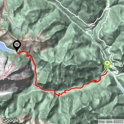
ROUTE MAP
MEMBER RATING
CURRENT WEATHER
PJAMM TRIPS ADVENTURE STARTER BUNDLES
Check out PJAMM Adventure's prepackaged (self-guided) cycling trips. They will help you plan, document and conquer your next adventure.
NEARBY CLIMBS (0) RADIAL PROXIMITY
FROM No Climbs Found
MEMBER REVIEWS & COMMENTS
Let us know what you thought of this climb. Signup for our FREE membership to write a review or post a comment.
Already have an account?
LOG IN HERE
Cyclopaat
The Malga Ciapela straight is probably the hardest stretch of all Dolomites climbs. You'll be rewarded with a beautiful hairpin section at the end of it.
andrewwhittaker43
Does it have the diversion off the main road that Michael Cotty talks about?
carbon23
No it is hard closed for construction right now. There are like 20 barriers in the way.
mat73

I did all Dolomites climbs and in my opinion it's the hardest one. Hodest point is the 4km straight road at 12% followed by a couple of turns at 15%! But after that you're at the top!
