
16
PDI
6.4 mi
DISTANCE
2,517 ft
GAINED
7.2 %
AVG. GRADE
FULL CLIMB STATS
INTRO
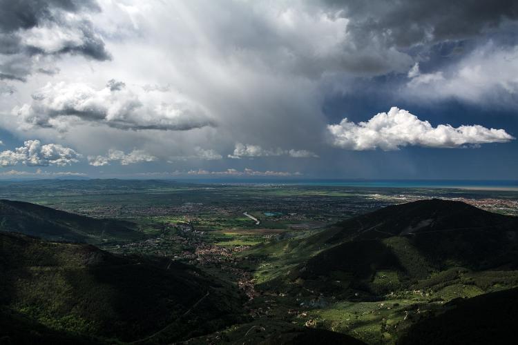
Monte Serra is the highest point in the province of Pisa and the obvious hill ride from the city, and Calci is the side with the view. You climb with the coast behind you, and every time the trees part you get more of it: the Valgraziosa below, Pisa out on the plain, Livorno, the sea, and on clear days some of the islands of the Tuscan archipelago. One rider rated it the best valley view of the three Monte Serra roads.
From Calci it's 10.4 km (6.4 mi) and 767 m (2517 ft) of climbing at 7.2%, and it climbs in steps. The first kilometer through the village is easy, then km 1-2 hits 10.3% as the road climbs out above the houses. Four kilometers at 5-7% follow on a wide road across open slopes - sunny and often windy - before the crux: km 6-8 average 10.4% and 10.9%. After that it eases to 8%, then 5-6% under the trees, where it's noticeably cooler, and it all but flattens out for the final stretch to the junction at 803 m.
The open slopes above Calci are still growing back after the fire of 24-25 September 2018, which burned hundreds of hectares of forest on Monte Serra. The summit itself, at 917 m, sits a short way above the junction, crowned by the RAI transmitter station. Every June the Trittico del Serra, a non-competitive ride, takes in all three sides in one go.
PLAN YOUR ROUTE
 We've partnered with Sherpa-Map.com to bring you the best route planning tool. With a PRO Membership you can use this climb as a reference when creating your route.
Monte Serra from Calci is 10.4 km (6.4 mi) long and climbs 767 m (2517 ft), from 64 m to 803 m (211 ft to 2636 ft), an average of 7.2%.
km 0-1: 4.9% through Calci.
km 1-2: 10.3% climbing out of the village.
km 2-6: 5-7% on the open middle section.
km 6-8: the crux - 10.4% and then 10.9%. The steepest kilometer averages 10.9% and the steepest 2 km 10%.
km 8-9: 8%.
km 9-10.4: 5.6% into the trees, then nearly flat to the junction.
The steepest half kilometer averages 12.3%.
km 1-2: 10.3% climbing out of the village.
km 2-6: 5-7% on the open middle section.
km 6-8: the crux - 10.4% and then 10.9%. The steepest kilometer averages 10.9% and the steepest 2 km 10%.
km 8-9: 8%.
km 9-10.4: 5.6% into the trees, then nearly flat to the junction.
Roadway: Tarmac from Calci to the junction, and wide by mountain-road standards, with guardrails on the open bends. Most riders rate the surface good, with one rougher patch a little before halfway. From the junction at the top, a short road continues toward the RAI transmitter station on the summit.
Traffic: Light to moderate. This is a popular training climb for riders from Pisa and Lucca, so expect company on weekend mornings, plus some cars heading for the top. Take care on the descent - it's fast, and the steep section at km 6-8 arrives quickly on the way down.
Parking: Park considerately in Calci near the start (start on Google Maps), or ride out from Pisa, about 10 km away on flat roads.
Gear: A compact with a 30 or 32 cog is plenty - the two kilometers near 11% at km 6-8 are the only real squeeze. In summer the middle of the climb is exposed to the sun, and one rider who rode it in August started at 6 am - good advice.
Provisions: Fill up in Calci, which has bars and shops, and bring enough to get you up and back down - don't count on anything being open at the top.
Before heading out on any cycling adventure check out our Things to Bring on a Cycling Trip and use our interactive check list to ensure you don't forget anything.
Calci's big sight is the Certosa di Calci, a former Carthusian monastery that now houses the University of Pisa's Natural History Museum - an easy rest-day visit, or a look on the way back from the ride. Pisa is only 10 km away, close enough to ride in and out of on a day off from the hills.
Monte Serra has two more paved sides, from Buti and from Pieve di Compito on the Lucca side, and all three finish at the same junction, so it's easy to string them together into a hard morning, the way the Trittico del Serra does. Our Monte Serra (Buti) and Monte Serra (Pieve di Compito) pages cover those roads. Around the mountain, the Monti Pisani olive oil route links the oil villages of Buti, Vicopisano and Calcinaia, with the Rocca del Brunelleschi at Vicopisano worth a stop.
ROUTE MAP

MEMBER RATING
CURRENT WEATHER
PJAMM TRIPS ADVENTURE STARTER BUNDLES
Check out PJAMM Adventure's prepackaged (self-guided) cycling trips. They will help you plan, document and conquer your next adventure.
NEARBY CLIMBS (0) RADIAL PROXIMITY
FROM No Climbs Found
MEMBER REVIEWS & COMMENTS
Let us know what you thought of this climb. Signup for our FREE membership to write a review or post a comment.
Already have an account?
LOG IN HERE
