
24
PDI
4.6 mi
DISTANCE
2,692 ft
GAINED
11.2 %
AVG. GRADE
FULL CLIMB STATS
INTRO
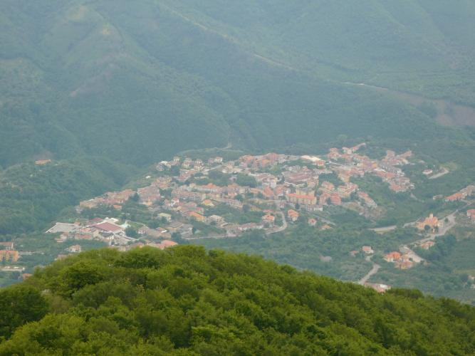
Rifugio Calvanico climbs 7.3 km (4.6 mi) from the edge of Fisciano to the Acqua Carpegna trailhead at 1118 m (3,669 ft), gaining 820 m (2,692 ft) at a punishing 11.2% average. It sits inside the Monti Picentini Regional Park, a limestone range inland from Salerno, and it ranks #637 on our world difficulty list - a remarkable number for a climb this short.
The climb comes in two halves. The first 3 km roll up through Calvanico at a manageable 7-9%. Once the village is behind you, the road narrows and tips up hard: the final 4.3 km (2.7 mi) average roughly 13%, climbing through olive groves and then dense beech forest, with short ramps near 18%. It's quiet, shaded, and relentless.
The road ends at a parking area at Acqua Carpegna, a mountain spring beside the old Casone De Fazio building. This is the jumping-off point for Pizzo San Michele (1567 m / 5,141 ft), whose summit chapel is the highest sanctuary dedicated to St. Michael the Archangel in Italy - a 2 km hike above the finish, and a pilgrimage site Calvanico still walks every May.
PLAN YOUR ROUTE
 We've partnered with Sherpa-Map.com to bring you the best route planning tool. With a PRO Membership you can use this climb as a reference when creating your route.
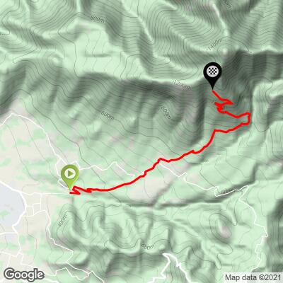
 Rifugio Calvanico is 7.3 km (4.6 mi) long and gains 820 m (2,692 ft) at an 11.2% average, from 298 m (977 ft) at the start to 1118 m (3,669 ft) at Acqua Carpegna.
Km 0-3: the warm-up through Calvanico, at 7.4%, 8.8% and 9.1% per kilometer.
Km 3-7.3: the real climb. The last 4.3 km (2.7 mi) average about 13.2%, with kilometer 4 at 14.4%, kilometers 5 and 6 at 12.2% and 12.6%, and kilometer 7 the hardest of all at 14.9%. The final few hundred meters ease to about 8.5% into the parking area.
Steepest sections: 100 yd (91 m) at 18.0%, 0.5 km at 15.9%, 1 km at 15.3%, 2 km at 14.1% and 5 km at 12.8%.
Roadway: Paved all the way to the Acqua Carpegna parking area. The upper road was rebuilt around 2022 after years in poor shape, but it's still a narrow mountain lane with some rough, patched stretches, and the surface under the beech canopy can stay damp and leaf-covered well after rain. Take the descent slowly - at 13-15% there's very little room for error.
Traffic: Light. You'll share the lower road with local traffic through Calvanico; above the village the only cars are hikers heading to the Acqua Carpegna trailhead, busiest on weekends and during the San Michele pilgrimage in May.
Parking: Fisciano has street parking near the start, and Calvanico's center is an option if you want to skip the gentler first 3 km and go straight at the steep part. At the top there's a large parking area at Acqua Carpegna next to the Casone De Fazio.
Gear: Bring your lowest gearing. With 4.3 km averaging over 13% and ramps near 18%, a compact with a 34x32 or bigger is not overkill, and a gravel-style 1x setup with a wide-range cassette is a reasonable choice here. If you plan to walk up Pizzo San Michele from the finish, pack shoes you can hike in - the path turns rocky near the top - plus a layer, since the north-facing slope holds snow into spring.
Provisions: There's nothing to buy above Calvanico, so fill bottles and pockets in Fisciano or in the village. The Acqua Carpegna spring at the top is the traditional water stop for hikers, but don't count on it as your only source.
Before heading out on any cycling adventure check out our Things to Bring on a Cycling Trip and use our interactive check list to ensure you don't forget anything.
Pizzo San Michele is the reason most people drive this road. From the Acqua Carpegna parking, CAI trail 115/116 climbs about 2 km and 450 m (1,476 ft) through beech forest to the summit chapel - plan on 1-1.5 hours up. Partway along the path, a small niche holding a statue of St. Michael carries an inscription dated 1616 warning pilgrims not to carry meat past that point. Next to the chapel, a small shelter room is left open for hikers, with tables and a fireplace, and on a clear day the view takes in Vesuvius, the Gulf of Naples and the Gulf of Salerno.
Calvanico celebrates San Michele, its patron saint, with a two-day festa each May, when the statue is carried from the village to the summit - a special time to visit, though the upper road is busier than usual.
Calvanico is only about 4 km from the Fisciano motorway exit on the Salerno-Avellino road, and Fisciano is home to the main campus of the University of Salerno, so the start is easy to reach from Salerno or Naples. Campania has plenty of other steep, quiet climbs - see what else is nearby, or build a longer day from here, with our Routes in the Area tool.
ROUTE MAP
MEMBER RATING
CURRENT WEATHER
PJAMM TRIPS ADVENTURE STARTER BUNDLES
Check out PJAMM Adventure's prepackaged (self-guided) cycling trips. They will help you plan, document and conquer your next adventure.
NEARBY CLIMBS (0) RADIAL PROXIMITY
FROM No Climbs Found
MEMBER REVIEWS & COMMENTS
Let us know what you thought of this climb. Signup for our FREE membership to write a review or post a comment.
Already have an account?
LOG IN HERE
