
20.5
PDI
6.9 mi
DISTANCE
2,969 ft
GAINED
7.8 %
AVG. GRADE
FULL CLIMB STATS
INTRO
PLAN YOUR ROUTE
 We've partnered with Sherpa-Map.com to bring you the best route planning tool. With a PRO Membership you can use this climb as a reference when creating your route.
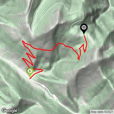
Chiaserna to the saddle is 11.1 km (6.9 mi) at a 7.8% average, with 905 m (2,969 ft) of gain. The first kilometer is the gentlest at 4.5%, and from there the grade rarely settles: the hardest kilometers come at 2-3 km (9.8%), 4-5 km (9.7%), 6-7 km (9.9%) and 9-10 km (10.3%), with short easier breaks of 5.4% and 4.7% in between.
The steepest 1 km averages 11.7% and the steepest mile (1.6 km) averages 11.4%. The steepest 500 m runs at 15.5%, and the single hardest 100 m reaches 18.7%. Over longer stretches the numbers are lower but still demanding: the steepest 5 km averages 8.9% and the steepest 10 km averages 8.2%. Pace the early switchbacks, because the sustained pitches are in the second half.
Roadway: The road is asphalt and follows the SP 110 (Chiaserna to Fonte Luca) and then the SP 134 to the saddle. The September 2022 flood damaged roughly 80% of the road network around Catria, and riders who tried the climb in 2023 reported a collapsed section above Fonte Luca. In early October 2026 the first 5 km of the SP 110 were repaved, with landslide consolidation, new guardrails and road markings still being completed. Short gravel patches of about 50 m have been reported higher up. Check current status with the Comune di Cantiano or the Provincia di Pesaro e Urbino before riding to the saddle; the provincial roads on Catria have also been subject to winter access limits in the past.
Traffic: Light. The road ends at the Madonna degli Scout saddle, so there is no through traffic - the cars you meet are mostly hikers heading for the Catria and Acuto trailheads. Riders describe very little traffic overall.
Parking: Chiaserna is a small village and the climb begins at its edge, so park in the village and start from there. The Catria regional horse fair is held in Chiaserna on the second weekend of October, when the village will be busy. At the top, the Madonna degli Scout monument (about 1,370 m) is where hikers leave their cars.
Provisions: There are no services on the climb itself, so fill bottles and pockets in Chiaserna or Cantiano before you start. The Rifugio Vernosa, about 2 km beyond the saddle on a gravel road, is a bivouac point rather than a cafe.
Gear: A compact crankset and a wide-range cassette (34 front, 30-34 rear) make sense for kilometers that regularly pass 10%. Temperatures drop noticeably between the valley and the shaded upper forest, so carry a light jacket for the descent, and consider slightly wider tires if you plan to continue onto the gravel toward the Vernosa hut.
Before heading out on any cycling adventure check out our Things to Bring on a Cycling Trip and use our interactive check list to ensure you don't forget anything.
Cantiano, the comune that owns Chiaserna, sits on the old Via Flaminia, the Roman road from Rome to the Adriatic. At the end of the Burano gorges (Gola del Burano) the nearly intact Roman Ponte Grosso is worth a stop, and the gorge road is a quiet mountain road that riders recommend as an alternative. In town, the former Augustinian convent houses the Museo archeologico della Via Flaminia, and the Gabrielli castle was converted into a palace-fortress in 1478 by Francesco di Giorgio Martini.
Chiaserna gives its name to the Pane di Chiaserna, a bread with a protected collective brand, and Cantiano is known for its sour cherry (visciola) products, including a cherry liqueur - good things to look for after the descent. Town calendar highlights are the Piazza del gusto food fair (second weekend of May) and the white truffle fair (third weekend of November).
The mountain has other approaches, covered on their own pages: the north side from Buonconsiglio-Colombara and the Grumale climb from Cagli. The Fonte Avellana monastery lies on the far side of the massif and is reached from the Frontone side rather than from this climb. See other climbs nearby, or build a custom route from here, with our Routes in the Area tool.
ROUTE MAP
MEMBER RATING
CURRENT WEATHER
PJAMM TRIPS ADVENTURE STARTER BUNDLES
Check out PJAMM Adventure's prepackaged (self-guided) cycling trips. They will help you plan, document and conquer your next adventure.
NEARBY CLIMBS (0) RADIAL PROXIMITY
FROM No Climbs Found
MEMBER REVIEWS & COMMENTS
Let us know what you thought of this climb. Signup for our FREE membership to write a review or post a comment.
Already have an account?
LOG IN HERE
