
17.4
PDI
9.5 mi
DISTANCE
3,068 ft
GAINED
6 %
AVG. GRADE
FULL CLIMB STATS
INTRO
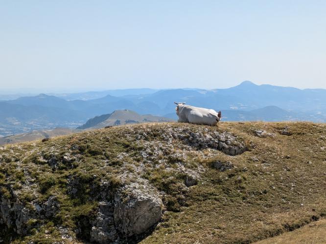
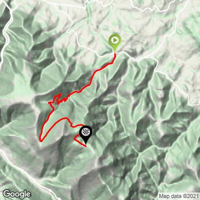
This is the steep side of Monte Catria. Of the three roads up the massif, the one from Buonconsiglio-Colombara, a hamlet below Frontone, puts almost all of its hard climbing into one stretch in the woods: three straight kilometers between 10% and 13%, with the steepest kilometer at 14.6%. In all it covers 15.3 km (9.5 mi) and gains 935 m (3068 ft) at 6.0%, finishing at the Madonna degli Scout saddle (1372 m), where the hiking trails to the 1701 m summit begin.
The first 3 km are almost flat, along the valley out of Buonconsiglio. The road tilts up through km 3 and 4, and from about km 4.5 the forest section begins - the kind of climbing where you stop thinking about speed. It eases at around 1000 m, and at km 10 joins the road up from Cagli for the last 5.3 km: three more solid kilometers at 6-8% across the ski slopes, past the Rifugio La Cotaline, then a flat run along the mountainside to the saddle and its Madonna degli Scout monument.
Check the road before you plan around it. The September 2022 flood tore up the roads around Frontone and Catria, this side was reported closed to traffic in early 2024, and a rider who tried it in late 2025 described it as washed away. The upper section shared with the Cagli road has been rebuilt since. Until the Comune di Frontone confirms the lower road is open again, the Cagli (Grumale) and Chiaserna sides are the safer way up.
PLAN YOUR ROUTE
 We've partnered with Sherpa-Map.com to bring you the best route planning tool. With a PRO Membership you can use this climb as a reference when creating your route.
Monte Catria from Buonconsiglio-Colombara is 15.3 km (9.5 mi) long and climbs 935 m (3068 ft) from 460 m (1509 ft) to 1372 m (4501 ft), an average of 6.0%.
The first 2 km (1.2 mi) along the valley are close to flat at 1.3%, and km 3 and 4 build from 4.5% to 7.1%. Kilometers 5, 6 and 7 are the heart of the climb at 13.0%, 12.8% and 10.4%. The steepest 500 m averages 15.6%, the steepest kilometer 14.6%, the steepest mile (1.6 km) 13.4% and the steepest 2 km 13.1%, with pitches of 17.4% over 100 yards.
Km 8 drops back to 3.7%. From km 9 to km 13 (mi 5.6-8.1) the grade holds between 6.0% and 8.2%, and the Cagli road joins at about km 10 (mi 6.2). The final 2.3 km (1.4 mi) to the saddle are almost flat at 0.3-1.4%. The steepest 5 km average 9.6%.
Roadway: A narrow, paved mountain road before the September 2022 flood, which hit Frontone very hard. The lower road from Buonconsiglio up through the steep forest section was badly damaged: in January 2024 it was reported closed to motor traffic, and a late-2025 rider report described it as washed away. Treat it as closed until the Comune di Frontone or the Provincia di Pesaro e Urbino says otherwise, and be ready to turn around. The upper 5.3 km (3.3 mi), shared with the climb from Cagli, was resurfaced in 2026 as part of the flood repairs on that road - our Monte Catria (Grumale) page has the details.
Traffic: Very light. The road ends at the saddle, so there's no through traffic; on the shared upper section you'll mostly meet cars heading for the ski area, the rifugio and the summit trails, and on the lower road next to nothing.
Parking: Park in Buonconsiglio-Colombara at the bottom, or in Frontone a couple of kilometers away and ride down to the start. At the top, hikers leave their cars at the Madonna degli Scout saddle for the trails to the summit and the Rifugio Vernosa.
Gear: Gear for the three kilometers above 10%, not for the 6% average: a 34 x 32 or 34 x 34 is not too much for most riders. With the flood damage on the lower road, 28 mm or wider tires make sense. The saddle is open and exposed, so bring a jacket for the descent.
Provisions: Fill bottles in Frontone before you start; there's nothing on the steep section. The Rifugio La Cotaline by the ski lifts, about 2 km below the saddle, is the only place on the upper mountain - it's busiest in ski season, so don't count on it midweek in summer.
Before heading out on any cycling adventure check out our Things to Bring on a Cycling Trip and use our interactive check list to ensure you don't forget anything.
Frontone's castle, the Castello della Porta, sits above the village with a bow-shaped plan attributed to Francesco di Giorgio Martini, the Renaissance military architect who also designed the Torrione in nearby Cagli. The food to try is crescia: a flatbread cooked over embers, spread with lard and filled with cured meat, cheese or greens, and the locals will tell you it is not a piadina. It gets its own festival in May, shared with the spignolo mushroom.
Up on the mountain, the ski area opened a summer Fun Village in 2025 with a giant swing and a 500 m monorail bobsled through the woods - handy if you're riding while the family isn't. The Benedictine monastery of Fonte Avellana, on the south side of the massif a short drive from Frontone, is the one Dante mentions in the Paradiso, and it's still worth the visit.
Catria's other two roads, from Cagli (Grumale) and from Chiaserna, have their own pages, and the Monte Nerone climbs rise on the far side of Cagli if you want a second mountain on the same trip.
ROUTE MAP
MEMBER RATING
CURRENT WEATHER
PJAMM TRIPS ADVENTURE STARTER BUNDLES
Check out PJAMM Adventure's prepackaged (self-guided) cycling trips. They will help you plan, document and conquer your next adventure.
NEARBY CLIMBS (0) RADIAL PROXIMITY
FROM No Climbs Found
MEMBER REVIEWS & COMMENTS
Let us know what you thought of this climb. Signup for our FREE membership to write a review or post a comment.
Already have an account?
LOG IN HERE
