
16.8
PDI
8.6 mi
DISTANCE
2,870 ft
GAINED
6 %
AVG. GRADE
FULL CLIMB STATS
Page Contributor(s): Helmuth Dekkers, Netherlands
INTRO
Saint-Imier is a watchmaking town - Longines was founded here in 1832 - and the road out of its south side gets straight to work. The first 4 km climb at 7.5 to 9.5% through the forest toward the Col des Pontins on a wide road where cars don't hang about. Then the gradient vanishes for a kilometer across the open fields at Les Pontins, and at Les Savagnières you turn onto the much narrower Route de Chasseral.
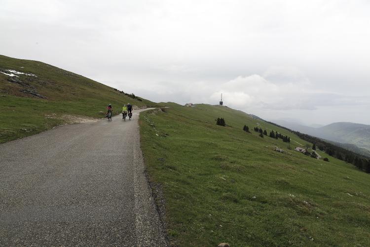
This is where the climb gets good. Two kilometers in the trees at just over 9% bring you out onto the open crest of the Jura - cattle grids, pasture, and on a clear day the Alps lined up along the southern horizon. After the Col du Chasseral the last 2.5 km are gentle: speed bumps past the Hôtel Chasseral, where cars have to stop, then a narrow lane for bikes and walkers up to the telecom tower.
In all it's 13.8 km (8.6 mi) with 875 m (2870 ft) of climbing at 6.0%, from 772 m (2533 ft) to 1601 m (5253 ft). The view from the top takes in the Three Lakes - Biel, Neuchâtel and Murten - with the Alps beyond. The road over the col has no winter service and closes every year from late autumn to spring, so plan this one for May to October.
PLAN YOUR ROUTE
 We've partnered with Sherpa-Map.com to bring you the best route planning tool. With a PRO Membership you can use this climb as a reference when creating your route.
13.8 km (8.6 mi) at 6.0%, gaining 875 m (2870 ft) from 772 m (2533 ft) in Saint-Imier to 1601 m (5253 ft) below the summit tower.
From the bridge in Saint-Imier the first 4 km climb at 7.3 to 9.4% per kilometer to about 1105 m (3625 ft); the steepest kilometer of the climb, at 9.7%, is right at the start. Kilometer 5 is close to flat (1.4%) across the fields at Les Pontins, and kilometer 6 averages 4.9% to the turn at Les Savagnières.
The Route de Chasseral then climbs 9.5% and 9.1% for two kilometers through the forest - the steepest 2 km of the route average 9.3%. Above the trees it eases to 5.1% and 2.8%, steepens to 6.4% for the kilometer to the Col du Chasseral around km 11, and finishes at 3.5 to 5% past the hotel and up the summit lane.
Roadway: Paved to the top. The road out of Saint-Imier toward the Col des Pontins is wide and in good condition. The Route de Chasseral from Les Savagnières is a narrow mountain road with cattle grids, and there are tall speed bumps between the col and the Hôtel Chasseral. The last 1.2 km from the hotel to the tower is a narrow asphalt lane closed to cars but open to bikes and walkers. The roads from Les Savagnières and from Nods up to the col get no winter service and close every year, usually from late October or November until late April or early May (in 2025-26 they were closed from 24 October to 1 May).
Traffic: The Pontins road carries steady traffic between Saint-Imier and the Val-de-Ruz, and some of it is fast and loud. Once you turn off at Les Savagnières it's quiet, apart from fine summer weekends when visitors drive up to the hotel and the weekend bus runs up from Saint-Imier.
Parking: Saint-Imier has several small public car parks around the center and the station, all a few minutes' ride from the bridge where the climb begins - or come by train, since the station is only about 400 m from the start. Drivers heading for the top can only go as far as the car park at the Hôtel Chasseral.
Gear: Gear for the 9% stretches out of Saint-Imier and through the forest above Les Savagnières; 34x30 or lower keeps them comfortable. The summit sits on an exposed ridge at about 1600 m (5249 ft) and is often windier and colder than Saint-Imier, so carry a windproof and gloves for the descent outside midsummer.
Provisions: Stock up in Saint-Imier before the start. The Hôtel Chasseral has a restaurant just before the summit lane - the only food on the upper road.
Before heading out on any cycling adventure check out our Things to Bring on a Cycling Trip and use our interactive check list to ensure you don't forget anything.
Saint-Imier is on the railway, so this climb works well without a car. From mid-May to late October the Chemins de fer du Jura also run a weekend and holiday bus from Saint-Imier station to the Hôtel Chasseral, handy for a support crew or a non-riding partner who wants to meet you at the top. A second weekend bus climbs from Nods and La Neuveville on the Lake Biel side.
The Hôtel Chasseral has rooms as well as its restaurant, so you can stay up on the ridge for sunset over the Alps and ride down in the morning. In town, the Longines museum (by reservation, weekdays) tells the story of the watchmaker founded here in 1832.
Chasseral's crest gets weather that Saint-Imier doesn't, so look at the summit forecast in our Weather tool, not the one for town, when deciding whether to go up.
ROUTE MAP

MEMBER RATING
CURRENT WEATHER
PJAMM TRIPS ADVENTURE STARTER BUNDLES
Check out PJAMM Adventure's prepackaged (self-guided) cycling trips. They will help you plan, document and conquer your next adventure.
NEARBY CLIMBS (0) RADIAL PROXIMITY
FROM No Climbs Found
MEMBER REVIEWS & COMMENTS
Let us know what you thought of this climb. Signup for our FREE membership to write a review or post a comment.
Already have an account?
LOG IN HERE
