
15.7
PDI
4.3 mi
DISTANCE
2,070 ft
GAINED
9.2 %
AVG. GRADE
FULL CLIMB STATS
Page Contributor(s): Roland Schuyer, Netherlands
INTRO
Cima Mutali doesn't waste any time. A kilometer after the last houses of Osteria del Gatto you're on a lane barely wider than a car, climbing through oak woods at 10%, and it keeps going like that more or less until it runs out of mountain - an open, grassy top with a telecom mast, a lot of sky and the valley around Fossato di Vico spread out behind you.
The figures: 6.9 km (4.3 mi) and 631 m (2070 ft) of climbing at 9.2%. Km 1-2 is 10.5%, then km 2-4 drop back to 7-8%, the only real breather. From there it kicks up again and the last 2.9 km average 10.2%, with km 5-6 the steepest at 10.9%. The woods thin out as you go - oak, then pines, then open grass - and the final few hundred meters are completely exposed, which is lovely on a still morning and hard work in a headwind.
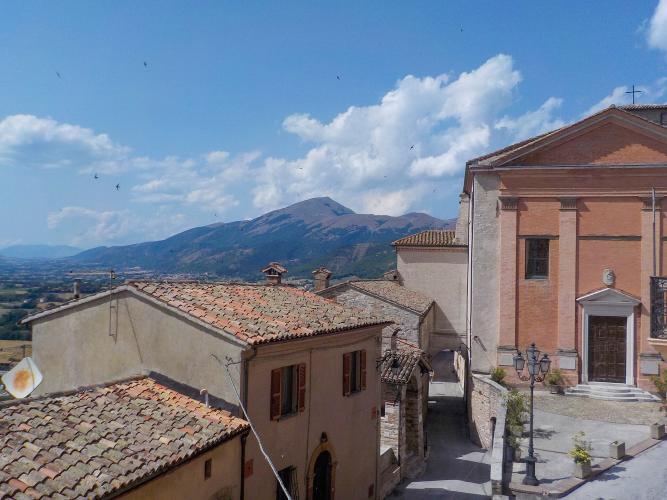
It's a short climb, but it rides like a much bigger one, and it's very quiet: no villages, no bars, hardly any cars. And at km 1 you ride right past the walls of Fossato di Vico, one of the better-preserved medieval villages on this side of Umbria - save it for the way down.
PLAN YOUR ROUTE
 We've partnered with Sherpa-Map.com to bring you the best route planning tool. With a PRO Membership you can use this climb as a reference when creating your route.
Overall: 6.9 km (4.3 mi) with 631 m (2070 ft) of climbing at a 9.2% average, from 443 m (1453 ft) in Osteria del Gatto to 1074 m (3524 ft) on Cima Mutali.
By kilometer: 8%, 10.5%, 7.9%, 7%, 9.5%, 10.9%, and 10.4% for the last 900 m.
Steepest sections: 500 m at 11.5%, 1 km at 11.1%, 2 km at 11%, 5 km at 9.4%.
Km 2-4 is the only stretch below 8%. The last 2.9 km, from 777 m to the top, average 10.2%.
Roadway: Paved to the top. Past the last houses it's a single-lane road with no center line and guardrails on the bends, patched in places, with grass and gravel along the edges. It stays that narrow all the way to the mast, and there's little room for a car to pass you.
Traffic: Very light - farm vehicles, the occasional car heading up to the masts and not much else. The lane is narrow and steep at both ends, so take the descent slowly and be ready for something coming up around a bend.
Parking: Park in Osteria del Gatto around Via del Campo Sportivo, where the climb starts (start point on Google Maps). Coming by train, the Fossato di Vico-Gubbio station is about 1 km away.
Gear: A 34x32 is the minimum most riders will want: there are almost 3 km at 10% to finish, and the steepest 500 m touches 11.5%. The top is open and often windy at 1074 m, and noticeably cooler than the valley, so carry a vest for the way down.
Provisions: Buy what you need in Osteria del Gatto or Fossato di Vico - there's nothing on the climb or at the top.
Before heading out on any cycling adventure check out our Things to Bring on a Cycling Trip and use our interactive check list to ensure you don't forget anything.
Fossato di Vico, just above the road at km 1, is worth a stop as you come down. Its walls and towers are intact, and the Rughe - covered walkways with stone vaults, pointed arches and wooden plank roofs, built into the old defenses - are unlike anything in Umbria's bigger towns. The little Piaggiola church has frescoes by Ottaviano Nelli, and the small town museum (weekends and holidays) keeps 14th-century fragments of Dante's Divine Comedy found in the covers of old registers. On the second weekend of May the Festa degli Statuti takes the town back to 1386.
Gubbio, which shares the railway station's name, is the nearest big town and an easy base. For more climbing, the Monte Catria roads in the Marche are about 20 km north - start with our Monte Catria (Chiaserna) page - and Routes in the Area maps out the rest of what's around Fossato.
ROUTE MAP

MEMBER RATING
CURRENT WEATHER
PJAMM TRIPS ADVENTURE STARTER BUNDLES
Check out PJAMM Adventure's prepackaged (self-guided) cycling trips. They will help you plan, document and conquer your next adventure.
NEARBY CLIMBS (0) RADIAL PROXIMITY
FROM No Climbs Found
MEMBER REVIEWS & COMMENTS
Let us know what you thought of this climb. Signup for our FREE membership to write a review or post a comment.
Already have an account?
LOG IN HERE
