12.1
PDI
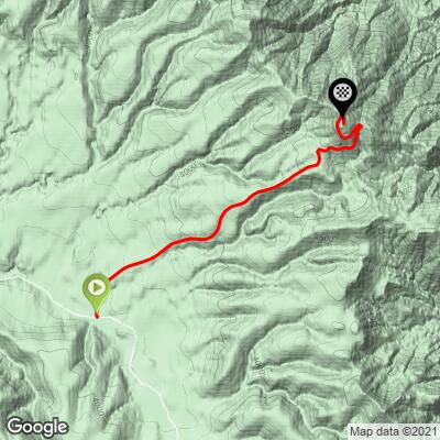
3.9 mi
DISTANCE
1,681 ft
GAINED
8.1 %
AVG. GRADE
FULL CLIMB STATS
INTRO
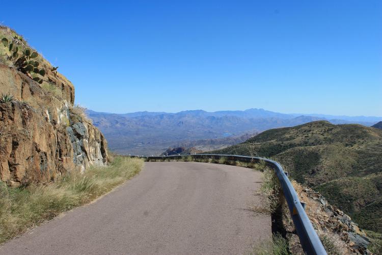
This climb is in the Sonora Desert with brush and dry grass as your scenery. We climb towards an FAA radar dome situated at the climb’s finish. This is one of the most difficult bike climbs in the Phoenix-Scottsdale area. This bike climb is entirely within the Tonto National Forest, the largest of six national forests in Arizona (and the fifth largest in the US), consisting of 2,873,200 acres and established in 1905.
"Included due to its isolation and use in USCF races, Humboldt Mountain is a stout Sonoran Desert climb on a narrow, poorly paved road. The climb ends on top of a mesa with some views..." (This quote is presented with the approval of John Summerson, from his book, The Complete Guide to Climbing (by Bike), 2nd Edition, pg. 127.)
PLAN YOUR ROUTE
This climb has an average grade of 8.1%. 38% (1.5 mile) of the climb is at 5-10% grade, and 43% (1.7 miles) is at 10-15%. The steepest quarter-mile is 11.2% and mile 10.5%.
See more details and tools regarding this climb's grade via the “Profile Tool” button.
Roadway: Single lane road in good condition - example of roadway at top of climb - Street View. Be cautious on the turns on the descent because you can descend fast and the road is extremely narrow creating a hazard if you encounter the rare vehicle on a turn traveling up the road.
Traffic: Almost none
Parking: Climb start - Map. The road to this climb is very rough and requires a gravel bike - we drive to the start of the climb when we come from Phoenix. You can park anywhere on the side of the road near the start of the climb.
This climb is very unsupported. The nearest accommodations are in Carefree back in the Phoenix area.
Before heading out on any cycling adventure check out our Things to Bring on a Cycling Trip and use our interactive check list to ensure you don't forget anything.
Information Not Available
If you have any information regarding this climb, we'd like to hear from you. Click the CONTRIBUTE button to share your thoughts with us.
ROUTE MAP
MEMBER RATING
CURRENT WEATHER
PJAMM TRIPS ADVENTURE STARTER BUNDLES
Check out PJAMM Adventure's prepackaged (self-guided) cycling trips. They will help you plan, document and conquer your next adventure.
NEARBY CLIMBS (0) RADIAL PROXIMITY
FROM No Climbs Found
MEMBER REVIEWS & COMMENTS
Let us know what you thought of this climb. Signup for our FREE membership to write a review or post a comment.
Already have an account?
LOG IN HERE
DustinStory
A fun climb if you’re in this part of town. The descent was super speedy! I rode the dirt road on 35mm and it was acceptable. Refilled at Ravens View bar on way back (8miles from base - the first civilization) and they were bike friendly with an outdoor bar. Road is great (not poorly paved at all) and the traffic is perfect (I met 2 cars)
ChefJeff
Good to know last time I did it was 2022. Did they repair the road. It was not that bad when I went there are worse roads in LA that are not in the middle of no where
DustinStory
No idea when they redid it but the blacktop was smooth 6 months ago. Dirt road to get there is still a journey