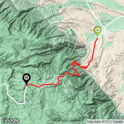
24.2
PDI
16.2 mi
DISTANCE
4,412 ft
GAINED
5.1 %
AVG. GRADE
FULL CLIMB STATS
Page Contributor(s): Bruce Hamilton, La Quinta, CA, USA; Stacy Topping, Tacoma, WA, USA
INTRO
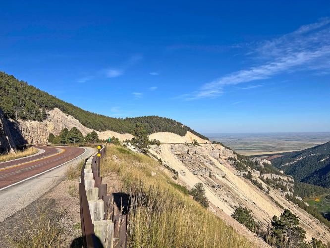
"This isolated climb heads up a narrow and somewhat twisty road towards the Big Horn Mountains of Wyoming. Around five miles into the climb the grade increases as you start to switchback up the hill with great views down into the valley. It ends after 14.9 miles at an unmarked top. You can continue to ride another 11.2 mostly flat miles to Burgess Junction and then go left for another 9.8 miles to reach Granite Pass but any significant climbing has ended." (This quote is presented with the approval of John Summerson, from his book, The Complete Guide to Climbing (by Bike), 2nd Edition, pg. 234.)
We missed this one on our cycling trip to Wyoming. If anyone has photos and a summary of the climb, we would very much appreciate the contribution to john@pjammcycling.com.
PLAN YOUR ROUTE
See more details and tools regarding this climb's grade via our interactive Profile Tool.
Information Not Available
If you have any information regarding this climb, we'd like to hear from you. Click the CONTRIBUTE button to share your thoughts with us.
Information Not Available
If you have any information regarding this climb, we'd like to hear from you. Click the CONTRIBUTE button to share your thoughts with us.
Before heading out on any cycling adventure check out our Things to Bring on a Cycling Trip and use our interactive check list to ensure you don't forget anything.
Information Not Available
If you have any information regarding this climb, we'd like to hear from you. Click the CONTRIBUTE button to share your thoughts with us.
ROUTE MAP
MEMBER RATING
CURRENT WEATHER
PJAMM TRIPS ADVENTURE STARTER BUNDLES
Check out PJAMM Adventure's prepackaged (self-guided) cycling trips. They will help you plan, document and conquer your next adventure.
NEARBY CLIMBS (0) RADIAL PROXIMITY
FROM No Climbs Found
MEMBER REVIEWS & COMMENTS
Let us know what you thought of this climb. Signup for our FREE membership to write a review or post a comment.
Already have an account?
LOG IN HERE
SeaRobin


Super super beautiful climb, definitely underrated. Awesome scenery all the way through that keeps changing and never gets stale. Definitely do the descent if you're up to it. Starts in a valley, then into some hairpins overlooking the valley below. Then up to a big gorge with a lot of interesting rock features
I parked in Dayton WY at a park and biked to the summit. It's quite exposed all the way to the top so just be wary of that. There was some traffic but everyone was super courteous and there are even sections with huge shoulders and two lanes.
With 4-5 miles to go, there's a little bit of a steep section, but other than that. It's not that bad of a climb.
Video of Descent: https://youtu.be/czOkE7OKI_o?si=D1-tkODY1svUZCEb