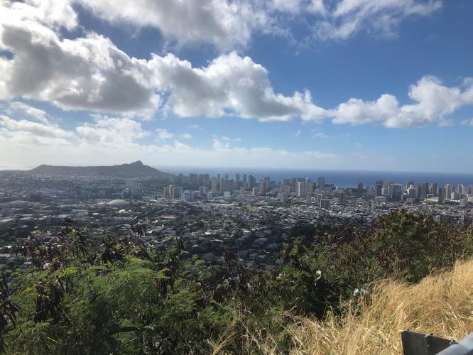
![Round Top Drive - Diamond Head Bicycle ride Round Top Drive - views of Diamond Head and Honolulu]()
Cycling Round Top Drive, Honolulu, Hawaii
Ride 4.9 miles to elevation 1,607’ gaining 1,526’ at 5.7%
View west to Diamond Head from mile 2.3
This top Oahu bike climb begins at the eastern edge of Honolulu and shares its start with its sister Climb,Tantalus Drive. The Tantalus and Round Top Drive cycling climbs are the most scenic climbs by bike in the Honolulu area.
You will not have to guess about the start - prominent in the Arche Baker Mini Park tucked between the start of the Tantalus and Round Top bike climbs is a spectacular earpod tree (Enterolobium cyclocarpum) that is included on Hawaii’s Exceptional Tree Map[1]
![Tantalus Drive - Earpod Tree Cycling Tantalus Drive - earpod tree at the start]()
Start - historically noted earpod tree.
![Earpod tree plaque Bicycle ride Round Top Drive - earpod tree plaque at start of climb]()
![Round Top Drive Bike climb up Round Top Drive - sign at start of climb]()
We merge onto Tantalus from Makiki Heights Drive and ride past large estate homes for a quarter mile until we are out of the Honolulu suburbs and into a fairly rural setting featuring tree tunnels and banyan trees.
![Round Top Drive - Puu Ualakaa State Park Climbing Round Top Drive - Puu Ualakaa State Park]()
State Park at mile 2.5
![Round Top Drive - hairpin Climbing by bike Tantalus Drive - hairpin]()
~12 hairpins along the climb.
![Round Top Drive - Honolulu and Diamond Head Bicycle ride up Round Top Drive - view of Honolulu and Diamond Head from viewpoint.]()
One of the best viewpoints of Honolulu and Diamond Head at mile 1.8.
The climb ends at Kalawahine Trail which is a 5.7 mile out-back hike through lush tropical trees and foliage.
![Round Top Drive - Kalawahine Trail Biking up Round Top Drive - Kalawahine Trail sign at the end]()
Caution if you hike here - reportedly very muddy.
Roadway surface and traffic: There is light traffic along the climb, but all cars we encountered were respectful and moving at the speed limit - 25-30 mph. The road is generally in good condition with just a couple rough spots to be wary of on the descent.
[1] “For the past two years, The Outdoor Circle has traveled across the State collecting information about the Exceptional Trees of Hawai‘i. By obtaining a tree's: GPS coordinates, diameter, height, condition and photo, we have been able to compile an extensive database for these important specimens. In using this data, we have been able to generate the estimated environmental and economic benefits of these trees, in the hopes of educating the public of the immense benefits that all trees have not only on the environment, but also our daily lives.” Exceptional Tree Map Home Page.

 We've partnered with Sherpa-Map.com to bring you the best route planning tool. With a PRO Membership you can use this climb as a reference when creating your route.

