Waipio Road Bike Climb - PJAMM Cycling

12.2
PDI
0.9 mi
DISTANCE
869 ft
GAINED
19.8 %
AVG. GRADE

FULL CLIMB STATS

INTRO

Waipio has the steepest average for its entire climb of any climb over a half-mile (in the category, its top dog). Several short stretches of roadway on other rides exceed Waipio’s 19%, but not for more than four-tenths of a mile.    

PLAN YOUR ROUTE

We've partnered with Sherpa-Map.com to bring you the best route planning tool. With a PRO Membership you can use this climb as a reference when creating your route.
19.4% average grade.  Gain 853' in 0.9 miles with 0 descent.  33% of the climb is at 15-20% and the majority of the climb (53%) is at or above 20%.  The steepest quarter-mile is 22.6%.

See more details and tools regarding this climb's grade via the “Profile Tool” button.
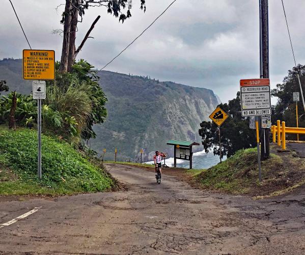
Roadway:  Well - this should tell you all you need to know - only four wheel drive vehicles are allowed.  The road is very narrow and in poor and broken condition with no center stripe or shoulder.  There are pull-outs to permit upcoming traffic to pass.  Be alert because it seems not all of the residents in the Waipio Valley appreciate all the traffic on their narrow road.  One guy on a motor scooter for no reason brushed me as I was riding up the road on the far right. 

Traffic:  Mild to mild-moderate.

Parking: At the top of the climb on the side of the road (you ride your bike to the bottom and then back up) - MapStreet View
Provisions:  We are on a very remote section of the Island of Hawaii.  The closest provisions are eight miles east at Honokaa Country Market (Map + 5 star Google Review).
Before heading out on any cycling adventure check out our Things to Bring on a Cycling Trip and use our interactive check list to ensure you don't forget anything.
Although the climb begins 9/10ths of a mile down the hill, be sure to ride your bike another mile or so on Waipio Valley Road to the stream that blocks your path - it is a neat little ride with jungle and river views.  Consider other climbs on the Island of Hawaii during your trip.  See our Hawaii page for more information here.

Also consider the Waipio Valley Trail hike.  This would have you riding your bike down to the bottom of the hill, locking it and picking up the hike from there, or starting at the top where All Trails starts the 4.7 mile out-and-back hike - All Trails - Waipio Valley Trail Hike.

As you can imagine, there is no shortage of beautiful hotels or vacation rental opportunities on the world class travel destination of Maui.

ROUTE MAP

MEMBER RATING

Difficulty: Extreme
2
Road
5
Traffic
5
Scenery

CURRENT WEATHER

PJAMM TRIPS ADVENTURE STARTER BUNDLES

Check out PJAMM Adventure's prepackaged (self-guided) cycling trips. They will help you plan, document and conquer your next adventure.
ALL TRIPS
Browse all of our prepackaged trips and find your next adventure!
Hawaii: Haleakala
United States (HI)
14 ROUTES
30 POIs
ROUTE STATS (TOTAL)
191.7
mi
DISTANCE
30,558
ft
ELEV. GAIN
Hawaii: Mauna Kea, Mauna Loa
United States (HI)
11 ROUTES
38 POIs
ROUTE STATS (TOTAL)
300.4
mi
DISTANCE
46,184
ft
ELEV. GAIN
Kauai
United States (HI)
13 ROUTES
10 POIs
ROUTE STATS (TOTAL)
98.3
mi
DISTANCE
24,063
ft
ELEV. GAIN
Oahu
United States (HI)
7 ROUTES
11 POIs
ROUTE STATS (TOTAL)
19.2
mi
DISTANCE
7,073
ft
ELEV. GAIN

NEARBY CLIMBS (0) RADIAL PROXIMITY

FROM
No Climbs Found

MEMBER REVIEWS & COMMENTS

Let us know what you thought of this climb. Signup for our FREE membership to write a review or post a comment.
Already have an account?

May 8, 2021
difficulty: Extreme
scenery: 5
traffic: 5
road: 2
May 8, 2021
scenery: 5
traffic: 5
road: 2
Did it on a GIANT Revolt Gravel but would have loved to have my Mountainbike for it. Incline is no joke, front wheel keeps wheeling up on you, and the pavement is really rough. Probably the most fun way to test out your maximum heart rate (you will max out for sure)
ROUTE MAP
PROFILE TOOL
Route Data
S.G. (%)
hide
Segment Data
hide
CLIMB SUMMARY

Cycling Waipio Road

Big Island, Hawaii

Cycle at a 19% average grade for about a mile.

This road is often (incorrectly) referred to as the steepest road in the US and world.  Of the climbs we have recorded, Waipio has the steepest average for its entire climb of any climb over a half mile (in the category, its top dog).  Several short stretches of roadway on other rides exceed Waipio’s 19%, but not for more than four-tenths of a mile.    

Waipio Valley is at the northern end of the Island of Hawaii (Big Island), 50 miles from Hilo, and 65 miles from Kona.  The one to 1½ hour trip to reach this brief climb is worth it -- this is an iconic and special bicycle climb.  But you may wonder, what exactly makes it so special?

Note:  As of March, 2022 this road is closed to visitors (including cyclists) for assessment and repair until further notice.  Check the net to determine if it is open if you intend to ride it.

Waipio Road is very scenic:

The scenery is spectacular and this climb is fantastic: located on a crumbling, narrow road in a jungle setting with the Pacific Ocean visible for much of the climb.

Hi'ilawe Falls can be seen about 1 mile past the start of the climb.

I stopped at the stream about a mile past the climb start.

Next time I’ll take my shoes off and carry my bike across -- shoulda done that this time.

Great views along the climb . . .

. . . but, really, who’s enjoying the scenery on this beast!

Waipio’s roadway is unique: 

The roadway along this climb is very rough and narrow, as evidenced in the photos below.

Downhill traffic must yield at the steepest sections to uphill traffic.

Waipio is the steepest road in the world:

No road in the world (longer than 400 yards) is steeper than Waipio Road.  Because of its steep incline, only four wheel drive vehicles are permitted on the road.

This road could not be ridden if it were wet (and it is often wet in these parts).  It is necessary to get out of the saddle on several 30%+ sections, and if the road were wet, there would just be no way to maintain traction on the rear wheel.

Made it.  👍👍