
21.8
PDI
14 mi
DISTANCE
4,071 ft
GAINED
5.2 %
AVG. GRADE
FULL CLIMB STATS
INTRO
PLAN YOUR ROUTE
 We've partnered with Sherpa-Map.com to bring you the best route planning tool. With a PRO Membership you can use this climb as a reference when creating your route.
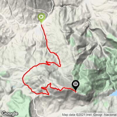
 Sierra de la Pandera averages 5.2% over 22.5 km (14.0 mi), but the climb is far from even. The steepest 10 km average 6.5% and the steepest 5 km 9.1%, and the hardest stretch is near the top: the steepest 2 km average 12.3%, the steepest kilometer 13.5%, and the steepest 100 yards (91 m) reaches 14.5%.
Along the lower A-6050 the grade is moderate and fairly consistent at around 5-7%, with a short descent totaling 69 m (226 ft) along the way. The real work starts once the road turns onto the summit road, with a stretch reported at around 15% for 1.8 km before switchbacks give some relief for the final push.
Roadway: The road is paved the entire way. The lower A-6050 is wide and in good condition. After the turn toward La Pandera the road narrows and the asphalt becomes rough, particularly in the final 5 km, and damage from nearby quarry traffic has been reported on the initial part of the summit road. The ridge is occupied by military installations, and the very highest point has been reported fenced off.
Traffic: Moderate on the lower sections and minimal higher up, where the summit road serves only the ridge installations. Expect cars around Los Villares and very little above the turnoff.
Parking: The climb starts at the edge of Los Villares, so any spot in town puts you on the road within minutes. Riders staying in Jaén city can add the 13 km ride out to the start.
Gear: The final ramps reach the mid-teens, so a compact crank with a 32-tooth or larger rear sprocket is strongly advisable. Lateral wind can also make itself felt on the upper slopes.
Provisions: Carry at least two full bottles. The upper mountain is exposed with no formal shelter, and Andalusian summer heat can be severe; an older ride report mentions a fountain on the lower slopes but it should not be relied on. Refill in Los Villares before starting.
Before heading out on any cycling adventure check out our Things to Bring on a Cycling Trip and use our interactive check list to ensure you don't forget anything.
Los Villares sits where the Eliche and Frío rivers meet, in a landscape dominated by rain-fed olive groves. The town's 15th-century Church of Saint John the Baptist and the 1775 Town Hall Chapter Houses are the main sights, and the Frío river feeds a mineral water bottling industry. The Quiebrajano reservoir is nearby.
Summer heat can be extreme on the exposed upper slopes, so early starts or spring and autumn rides are the smart choice. A second approach climbs from Valdepeñas de Jaén, and our Vuelta a España Stage 14 page covers the whole race route. Check current conditions at the base and the top with our Weather tool before you go.
ROUTE MAP
MEMBER RATING
CURRENT WEATHER
PJAMM TRIPS ADVENTURE STARTER BUNDLES
Check out PJAMM Adventure's prepackaged (self-guided) cycling trips. They will help you plan, document and conquer your next adventure.
NEARBY CLIMBS (0) RADIAL PROXIMITY
FROM No Climbs Found
MEMBER REVIEWS & COMMENTS
Let us know what you thought of this climb. Signup for our FREE membership to write a review or post a comment.
Already have an account?
LOG IN HERE
