
18.4
PDI
6.1 mi
DISTANCE
2,628 ft
GAINED
8.2 %
AVG. GRADE
FULL CLIMB STATS
INTRO
PLAN YOUR ROUTE
 We've partnered with Sherpa-Map.com to bring you the best route planning tool. With a PRO Membership you can use this climb as a reference when creating your route.
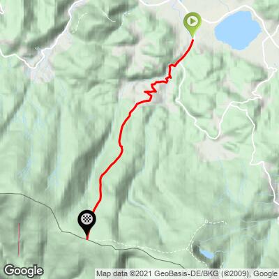
The first 5 km (3.1 mi), from Podgórzyn through Przesieka, are a warm-up by this climb's standards: each kilometer runs between 3.4% and 6.1%, for an average of about 5.3%.
Everything changes in the forest. Kilometer 6 climbs at 9.3% and kilometer 7 at 13.7%; kilometer 8 eases to 7.7%, then kilometer 9 averages 11.5% and the final 0.8 km (0.5 mi) to the pass averages 14.6%. The steepest 500 m (0.3 mi) averages 16.6%, the steepest 1 km (0.6 mi) 15.9%, the steepest 2 km (1.2 mi) 12.1% and the steepest 5 km (3.1 mi) 11.0%, and individual ramps are steeper still - figures of up to 24% have been published for the Polish road. With the hardest gradients saved for the very end, ride the first half conservatively.
Roadway: Paved, but the quality falls away as you climb. The asphalt around the Chybotek guesthouse is already rough, and the upper forest section is worn and patched, with some broken stretches. The upper road lies inside Karkonosze National Park, and local route guides recommend riding it only in summer, in good weather and with real caution. The Polish-side descent is steep and rough enough that many riders continue over the pass toward Špindlerův Mlýn instead - but the first part of the Czech descent, right at the border, also has a poor surface, so keep your speed down there too.
Traffic: Expect ordinary village traffic through Podgórzyn and Przesieka. Above the barriers by the Chybotek guesthouse the forest road is far quieter, and the main things to watch for are the surface and the gradient rather than cars.
Parking: Start near the Sosnówka reservoir in Podgórzyn (our Przełęcz Karkonoska (Podgórzyn) page has more on parking in the village). At the top there is plenty of room around the pass and the two huts to stop, regroup and refuel.
Provisions: The two huts at the top are the natural refuel stop: the PTTK Odrodzenie hut on the Polish side serves regional food and has rooms, and the Špindlerova bouda hotel complex sits just across the border. Below that there is nothing to buy once you leave Przesieka, so carry enough for the steep upper half.
Gear: Run the lowest gearing you own - the final 4.8 km (3.0 mi) average about 11% with ramps well beyond that. Carry ID if you plan to cross into the Czech Republic, a helmet, basic repair tools and a first-aid kit, as local route guides advise for this road. The ridge is colder and windier than the valley, so pack a layer for the descent.
Before heading out on any cycling adventure check out our Things to Bring on a Cycling Trip and use our interactive check list to ensure you don't forget anything.
Our Przełęcz Karkonoska (Podgórzyn) page covers Przesieka and its Podgórna waterfall, so this page looks at the pass and its huts.
Špindlerova bouda has a long and dramatic history. Franz Spindler, the village reeve of Bedřichov, built the first chalet here in 1824; it burned in 1826 and was rebuilt the same year on the original foundations, then burned again in 1885 and was rebuilt in 1886. A wide road was built up from Špindlerův Mlýn between 1914 and 1921, with a toll for cars and buses, and by 1942 the hut had 110 beds. During the Second World War, Allied prisoners of war were held there. After a 1978 demolition order, a new resort was built on the site, the basis of today's hotel. On the Polish side, the building that is now Odrodzenie was confiscated from its Jewish owner under Nazi rule and used as a Hitler Youth hostel.
On the way up you cross the Droga Sudecka, a road begun just before the war to run along the Sudetes; only the Podgórzyn-Borowice stretch was ever built, and a cemetery in Borowice commemorates the prisoners of war who worked on it. See other climbs on both sides of the border with our Routes in the Area tool.
ROUTE MAP
MEMBER RATING
CURRENT WEATHER
PJAMM TRIPS ADVENTURE STARTER BUNDLES
Check out PJAMM Adventure's prepackaged (self-guided) cycling trips. They will help you plan, document and conquer your next adventure.
NEARBY CLIMBS (0) RADIAL PROXIMITY
FROM No Climbs Found
MEMBER REVIEWS & COMMENTS
Let us know what you thought of this climb. Signup for our FREE membership to write a review or post a comment.
Already have an account?
LOG IN HERE
