
23.2
PDI
8 mi
DISTANCE
3,244 ft
GAINED
7.7 %
AVG. GRADE
FULL CLIMB STATS
Page Contributor(s): Jose Jiminez, Madrid; Jerry Root, Utah
INTRO
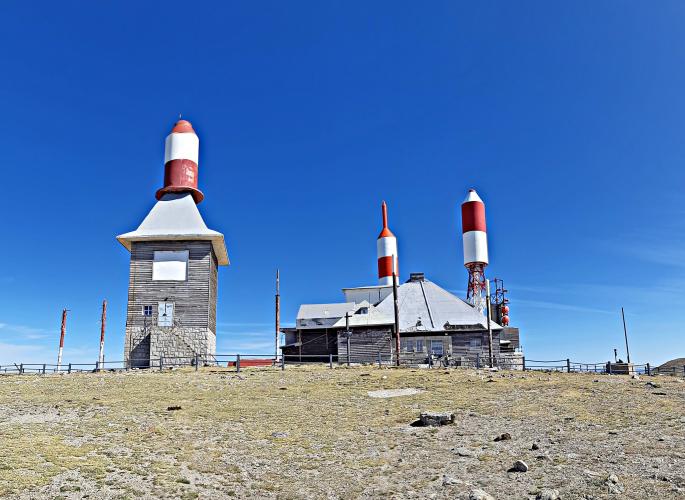
This is the Segovia-side approach to Bola del Mundo, the antenna-topped summit of the Sierra de Guadarrama above Puerto de Navacerrada. From the Los Asientos picnic area in the Valsaín pine forest it climbs 12.9 km (8.0 mi) at a 7.7% average, gaining 989 m (3,244 ft) to finish at 2255 m (7,399 ft). It's shorter and much greener than the Madrid-side route - see our Bola del Mundo (Collado Villalba) page - but it has the same brutal finale.
After a nearly flat 2 km beside the Eresma river, the CL-601 climbs steadily at 6-9% through the Scots pines of the Montes de Valsaín, including the Siete Revueltas, the string of hairpins below the pass, to reach Puerto de Navacerrada (1858 m / 6,096 ft) at about km 9.6. There the character changes completely: the last 3.2 km follow a narrow service road, closed to cars, at more than 12% on average, with pitches close to 18%.
Longtime contributor Jerry Root (Utah) put it plainly: the upper section's surface is "crumbling cement with quite a few small breaks and a few bigger potholes," and it's "one of the hardest climbs I've ever done because of that surface." (More on the gate and the surface in the Roadway & Parking tab.)
The Vuelta a España has finished on Bola del Mundo three times - Ezequiel Mosquera won in 2010, Denis Menchov in 2012, and Jonas Vingegaard in 2025, sealing his overall victory. The pass itself is in transition: in March 2026 Spain's Supreme Court upheld the dismantling of the Navacerrada ski station's slopes on the Castilla y León side, ending nearly nine decades of alpine skiing there.
PLAN YOUR ROUTE
 We've partnered with Sherpa-Map.com to bring you the best route planning tool. With a PRO Membership you can use this climb as a reference when creating your route.
 From Los Asientos, Bola del Mundo climbs 12.9 km (8.0 mi) at a 7.7% average, gaining 989 m (3,244 ft) from 1274 m (4,181 ft) to 2255 m (7,399 ft), with about 8 m (26 ft) of descent along the way.
Km 0-2: nearly flat, 2.1-2.6% along the Eresma.
Km 2-9.6: the CL-601 to Puerto de Navacerrada - 5.9-8.7% per kilometer through the pine forest and the Siete Revueltas hairpins.
Km 9.6-12.9: the gated road to the summit - 12.6%, 12.8% and 11.3% per kilometer, about 3.2 km at over 12% on broken concrete.
Steepest sections: 100 yd (91 m) at 17.6%, 0.5 km at 15.5%, 1 km at 13.4%, 2 km at 13.1%, 5 km at 10.3% and 10 km at 8.8%.
Roadway: The CL-601 is the main paved road between Segovia and Madrid over Puerto de Navacerrada, climbing through the Valsaín forest with a steady grade and the Siete Revueltas hairpins below the pass. Above the pass, the final 3.2 km to Bola del Mundo is a different world: a narrow service road of grooved, crumbling concrete with small breaks and a few real potholes. It's rideable, but it demands full attention on the way up and even more on the way down.
Traffic: The CL-601 carries steady traffic between Segovia and Madrid and gets busy on weekends, especially in winter when day-trippers head for the snow at the pass. Weekday mornings are the best time to ride it. Once you're through the gate above the pass, there's no car traffic at all - only hikers.
Parking: Los Asientos has a car park beside the picnic area at km 12.3 of the CL-601 - an easy, shaded place to start. At the top, Jerry Root's directions still apply: from the pass, enter the ski-area car park, take a hard right and then a quick left up the rocky access road toward the gate. Go through the gate (he found it open) to begin the steep final section to the antennas.
Gear: The first 9.6 km are a steady climb that any compact handles comfortably; the final 3.2 km at 12%+ on broken concrete is where you'll want your lowest gear and tires with some volume. Good brakes matter more than usual on the descent from the antennas.
Provisions: Los Asientos has picnic tables and water fountains but no bar, so arrive stocked. Valsaín and La Granja de San Ildefonso, a few kilometers down the valley, have cafes and shops. Nothing is available above the pass, and the summit is exposed and much colder than the valley - even in July, the average daily high at Puerto de Navacerrada is only about 23°C (73°F), and cloud and wind roll in fast.
Before heading out on any cycling adventure check out our Things to Bring on a Cycling Trip and use our interactive check list to ensure you don't forget anything.
This side of the mountain is Segovia's royal country. Just below the Valsaín forest, La Granja de San Ildefonso is home to the 18th-century Royal Palace of La Granja and its fountain gardens, as well as the Royal Glass Factory, and Valsaín itself keeps the ruins of an older royal palace. Segovia, with its Roman aqueduct, is less than 20 km (12.4 mi) away.
The start at Los Asientos sits right on the Eresma, whose flat, shallow stretch here is a favorite with families in summer. Along the river's left bank you can still see traces of the Camino de las Pesquerías Reales, a riverside path laid out for King Carlos III's fishing trips, and the old Puente de los Canales is a short walk downstream. The pine forest around you, the Montes de Valsaín, is publicly managed and held up as a model of sustainable forestry.
Puerto de Cotos, La Morcuera and the Madrid-side climbs to Navacerrada are all close by - see other climbs nearby, or build a custom route from here, with our Routes in the Area tool.
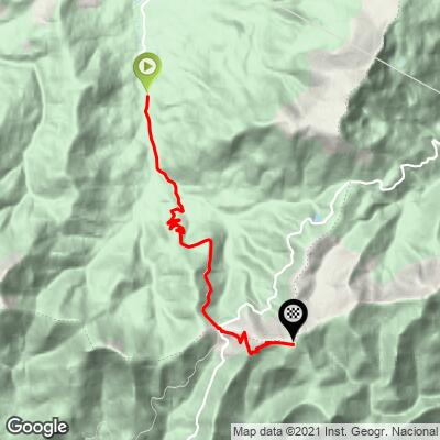
ROUTE MAP
MEMBER RATING
CURRENT WEATHER
PJAMM TRIPS ADVENTURE STARTER BUNDLES
Check out PJAMM Adventure's prepackaged (self-guided) cycling trips. They will help you plan, document and conquer your next adventure.
NEARBY CLIMBS (0) RADIAL PROXIMITY
FROM No Climbs Found
MEMBER REVIEWS & COMMENTS
Let us know what you thought of this climb. Signup for our FREE membership to write a review or post a comment.
Already have an account?
LOG IN HERE
Tigerwanito
I actually climbed it (in 2012) from the Puerto de los Cotos, but sort of crossed the CL-601 before that, as I was riding through the woods (from the Puerto de la Fuenfria) with a mountain bike... a very pleasant ride!
Anyway, the most remarkable part here is the very steep finale between the Puerto de Navacerrada and the Bola del Mundo, on grooved concrete: once there, you won't be bothered by any trafic anymore (this final part is closed to cars), and you'll be able to enjoy a wonderful (and well-deserved) view at the top, close to the antennas, whose colours reminded me of Tintin's rocket... 😉
Siapattack
Hey Tigerwanito! This looks amazing....I saw you did Mauna Loa + Mauna Kea in a day, and wanted to get input (duration, equipment, food, etc.). Not sure how to contact you. Would you be willing? I'm on Gmail. Danielsiapin. Just add the at symbol.
